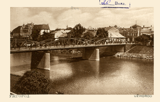
Footbridge over the River Ung
Пішохідний міст
Footbridge over the River Ung
Пішохідний міст
Original function:
bridge
Current function:
bridge
Settlement:
Address:
Pishokhidnyy Mist
Historical Hungarian county:
Ung
Country:
Ukraine
GPS coordinates:
48.621655, 22.298061
Google map:
Useful links
History
It was originally a wooden bridge destroyed by a flood. It was rebuilt as an iron bridge between 1896 and 1897. It connected the Petőfi and Theatre squares on the two banks of the river Ung. The bridge was destroyed in World War II, the current bridge was built in the Soviet era.
Check out other sights in Ungvár as well!
Show on Google map
© OpenStreetMap contributors
{"item":"sight","set":{"sightId":974,"townId":48,"active":1,"name_LO":"\u041f\u0456\u0448\u043e\u0445\u0456\u0434\u043d\u0438\u0439 \u043c\u0456\u0441\u0442","address":"Pishokhidnyy Mist","mapdata":"1|532|1452","gps_lat":"48.6216550000","gps_long":"22.2980610000","religion":0,"oldtype":"30","newtype":"30","homepage":"","openinghours":"","muemlekemlink":"","csemadoklink":"","picture":"\u003Ca title=\u0022See page for author \/ Public domain\u0022 href=\u0022https:\/\/commons.wikimedia.org\/wiki\/File:Uzhhorod_WDL10046.png\u0022\u003E\u003Cimg width=\u0022512\u0022 alt=\u0022Uzhhorod WDL10046\u0022 src=\u0022https:\/\/upload.wikimedia.org\/wikipedia\/commons\/thumb\/3\/34\/Uzhhorod_WDL10046.png\/512px-Uzhhorod_WDL10046.png\u0022\u003E\u003C\/a\u003E","picture_ref":"","name":"Footbridge over the River Ung","note":"","history":"It was originally a wooden bridge destroyed by a flood. It was rebuilt as an iron bridge between 1896 and 1897. It connected the Pet\u0151fi and Theatre squares on the two banks of the river Ung. The bridge was destroyed in World War II, the current bridge was built in the Soviet era. ","town":{"townId":48,"name_HU":"Ungv\u00e1r","name_LO":"\u0423\u0301\u0436\u0433\u043e\u0440\u043e\u0434","seolink":"ungvar-uzhhorod","oldcounty":20,"country":3}},"language":"en","region":"ukraine","regionid":3,"offer":[],"gallery":false,"album":false}

