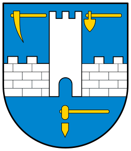
Selmecbánya
Banská Štiavnica
Selmecbánya
Historical Hungarian county:
Hont
District:
Banskobystrický kraj
GPS coordinates:
48.458743, 18.893297
Population
Population in 1910
| Total |
15185 |
| Hungarian |
41.75% |
| Slovak |
54.93% |
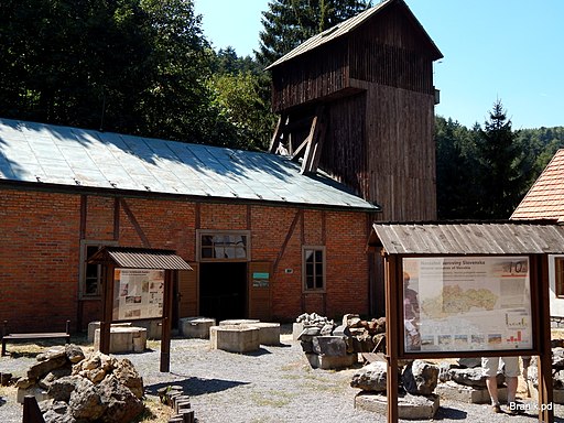
The town was one of the most important mining towns of Hungary, its silver and gold mines were among the most significant. Stephen I of Hungary already minted coin from the silver mined here. The settlement was destroyed during the Mongol Invasion and was repopulated by German miners. Hungary gave one quarter of the global silver production at that time. King Charles I of Hungary started minting silver coins called garas, which kept a constant value, in 1329. The town's defenses were built during the 1500s because of the Turkish threat, but the town was never occupied by them. The world's first Mining Academy was established here in 1770, which became the model for the Polytechnique in Paris. Selmecbánya was the third largest town of Hungary at that time. With the decline of mining, it became an important school town, and the Academy of Mining and Metallurgy expanded with a faculty of forest engineering. All this ended with the Czechoslovak occupation in 1919, when the Academy had to move to the territory of present-day Hungary. Several mining tunnels and a mining museum provide an insight into the town’s mining past.
Check out other towns in Upper Hungary (Slovakia) as well!
895
Arrival of the Hungarians
Little more...
895
The alliance of the seven Hungarian tribes took possession of the then largely uninhabited Carpathian Basin. Until then, the sparse Slavic population of the north-western Carpathians had lived under Moravian rule for a few decades after the collapse of the Avar Khaganate in the early 9th century.
1000
Foundation of the Hungarian Kingdom
Little more...
1000
The Kingdom of Hungary was established with the coronation of King Stephen I. He converted the Hungarians to Christianity and created two archdioceses (Esztergom and Kalocsa) and ten dioceses. He divided Hungary into counties led by ispáns, who were appointed by the king.
11th century
King Stephen I of Hungary minted silver coins using the silver mined here. The mint was located in Esztergom until the 13th century. Denar and obol (obulus) were minted. The obol had half the value of a denar.
1075
The silver mining of Selmecbánya was mentioned for the first time.
1217
It was mentioned by the names "Bana, Banya".
13th century
The chirch of Virgin Mary was built.
1241-1242
Mongol Invasion
Little more...
1241-1242
The hordes of the Mongol Empire invaded Hungary and almost completely destroyed it. One third to one half of the population was destroyed. The Mongols also suffered heavy losses in the battle of Muhi and they could not hunt down the king. After their withdrawal, King Béla IV reorganized Hungary. He allowed the feudal lords to build stone castles because they were able to successfully resist the nomadic Mongols. The vast majority of stone castles were built after this. The king called in German, Vlach (Romanian) and Slavic settlers to replace the destroyed population.
1275
The monks of the Dominican Order built their church dedicated to St. Nicholas.
1238
King Béla IV of Hungary made Selmecbánya a free royal town.
before 1241
King Béla IV made a contract with a German mining company, which made the deeper silver veins exploitable by the use of a water extraction machine.
autumn 1241
The town was destroyed by the Mongol invaders.
after 1242
After the Mongol invasion Bavarian and Saxon migrants were settled down, who founded the settlement in its current location.
1301
The extinction of the House of Árpád
Little more...
1301
The House of Árpád, the first Hungarian royal dynasty, died out with the death of King Andrew III. Hungary was ruled by oligarchs, the most powerful of whom was Csák Máté, whose main ally was the Aba family. King Charles I (1308-1342), supported by the Pope, eventually emerged as the most prominent of the contenders for the Hungarian throne. But it took decades to break the power of the oligarchs.
early 14th century
The Hungarian oligarch Csák Máté ruled the settlement.
1321
After the death of Csák Máté, King Charles I of Hungary occupied the town.
1325
King Charles I of Hungary started to produce gold florins in the mint of the town. The king founded other Minting Chambers besides Esztergom and Buda. The Hungarian mints, which gained their fame in the following centuries, were established at that time. There were altogether 10 mints in the country (Buda, Kolozsvár, Nagybánya, Körmöcbánya etc.).
1440
After the death of King Albert of the House of Habsburg, the Estates of Hungary elected the Polish Ulászló to the throne. Elisabeth, the widow queen, in order to secure the throne for László, her baby boy, called in the Czech Hussite mercenary leader Jan Jiskra. She gave him the title "Captain of the Mining Towns and Kassa", and gave him the castle of Zólyom.
1440-1441
The Czech Hussites soon occupied much of northern Hungary. They reinforced the castles and turned them into bandit lairs. They were pillaging everywhere and large areas became uninhabited. They wiped out the local German and Hungarian population, who were replaced by Czech and other Slavic settlers. The Czech Hussite devastation largely contributed to the Slavicisation of northern Hungary (now Slovakia).
1442
The Hussite captain of Selmecbánya attacked Eger, the town of Bishop Rozgonyi Simon, who supported King Ulászló I. The Czechs looted the town but did not dare to attack the castle. The Hussites were pursued by the army of the bishop and of Baron Czudar Jakab. In the forest near Szölöske the Hussite commander Talafuz was captured. As a revenge the bishop occupied Selmecbánya and looted and burned its houses.
1443
A terrible earthquake shook the town.
1462
At the end of the war that King Matthias of Hungary had waged against the Hussites since 1458, Jiskra swore loyalty to the king and handed over the castles he still held. Afterwards Jiskra fought in the service of King Matthias until his death.
1526
The king's military quelled the uprising of the miners.
1526
Battle of Mohács and the splitting of Hungary into two parts
Little more...
1526
Sultan Suleiman I launched a war against Vienna, instigated by the French. Ferdinand I, Duke of Austria, was the brother-in-law of King Louis II of Hungary. The army of the Ottoman Empire defeated the much smaller Hungarian army at Mohács, and King Louis II died in the battle. A group of the barons elected Ferdinand I of the House of Habsburg to the throne, who promised to defend Hungary from the Turks. He was the younger brother of the most powerful European monarch Emperor Charles V. But the nobility chose the most powerful Hungarian baron, Szapolyai János, who was also crowned as King John I. The country was split in two and a decades-long struggle for power began.
1541
The Turkish occupation of the capital, Buda, and the division of Hungary into three parts
Little more...
1541
The Turks conquered Buda, the capital of Hungary, after the death of King John I. The central part of the country was under Turkish rule for 150 years. The western and northern parts (including present-day Slovakia) formed the Kingdom of Hungary ruled by the Habsburg emperors. The eastern parts (now mainly under Romanian rule) were ruled by the successors of King John I of Hungary. In 1571, John II (John Sigismund), the son of King John I of Hungary, renounced the title of King of Hungary in favor of King Maximilian of the House of Habsburg, and henceforth held the title of Prince. This formally created the Principality of Transylvania, which was the eastern half of Hungary not ruled by the Habsburgs and was also a vassal of the Ottoman Empire. John II died in 1571, after which the three nations of Transylvania (the Hungarian nobility, the Székelys and the Saxons) elected the prince.
1546-59
After the Turks occupied Buda, the Gothic parish church was transformed into a fortified church encircled by walls. This is the so called Old Castle.
1564 – 71
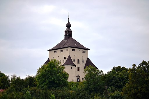
The New Castle, also called the Daughter Castle, was constructed against the Turks. It functioned as a fire tower since the 18th century.
1575
The Turks occupied the castles of Somoskő, Kékkő and Divény, so they got dangerously close to the town. The direct threat ended in 1593, when the castles of Nógrád County were taken back.
1604-1606
Uprising of Bocskai István
Little more...
1604-1606
The alliance of the Habsburgs and the Principality of Transylvania was defeated by the Ottoman Empire in the Fifteen Years' War. The war devastated Transylvania, which was occupied by the Habsburg imperial army, and General Basta introduced a reign of terror. The nobility and the burghers were upset about the terror, the plundering mercenaries and the violent Counter-Reformation. Bocskai István decided to lead their uprising after the Habsburg emperor tried to confiscate his estates. Bocskai also rallied the hajdú warriors to his side. He was elected Prince of Transylvania and soon liberated the Kingdom of Hungary from the Habsburgs. In 1605 Bocskai István was crowned King of Hungary with the crown he received from the Turks.
1605
Bocskai István occupied the town peacefully.
23 June 1606
Peace of Vienna
Little more...
23 June 1606
Bocski István made peace with Emperor Rudolf. Their agreement secured the constitutional rights of the Estates of Hungary, and the freedom of religion. The counties of Szatmár, Bereg and Ugocsa were annexed to the Principality of Transylvania. Bocskai died of illness in the same year, leaving to his successors the idea of unifying Hungary from Transylvania.
1619
The campaign of Prince Bethlen Gábor of Transylvania in the Thirty Years' War
Little more...
1619
At the beginning of the Thirty Years' War (1618-1648), Prince Bethlen Gábor of Transylvania went to war against the Habsburg emperor as an ally of the rebelling Czech-Moravian-Austrian estates. The whole Kingdom of Hungary joined him, only the Austrian defenders of Pozsony had to be put to the sword. With his allies, he laid siege to Vienna. However, he was forced to abandon the siege because the Habsburg-loyal Hungarian aristocrat Homonnai Drugeth György attacked his heartland with Polish mercenaries. On 25 August 1620, the Diet of Besztercebánya elected Bethlen Gábor King of Hungary as vassal of the Turks. He continued to fight after the defeat of the Czechs at White Mountain on 8 November 1620, but without real chance to achieve decisive victory, he decided to come to an agreement with Emperor Ferdinand II.
1619
Prince Bethlen Gábor of Transylvania captured Selmecbánya without a fight. The Ispán of Zólyom was at that time the Habsburg-friendly Esterházy Miklós.
early June, 1621
Selmecbánya surrendered to the Imperials.
July 5, 1621
After the victory of Egry István at Zólyom, the town surrendered to Prince Bethlen Gábor again.
31 December 1621
Peace of Nikolsburg
Little more...
31 December 1621
Prince Bethlen Gábor of Transylvania made peace with Emperor Ferdinand II. Their agreement secured the constitutional rights of the Estates of Hungary, and later it was supplemented with the freedom of religion. Bethlen renounced the title of King of Hungary in exchange for seven counties of the Upper Tisza region (Szabolcs, Szatmár, Bereg, Ugocsa, Zemplén, Borsod, Abaúj) for the rest of his life, other estates in Hungary as his private property and the imperial title of Duke of Oppeln and Ratibor (Opole and Racibórz), one of the Duchies of Silesia. Prince Bethlen went to war against the Habsburgs in 1623 and 1626, but was unable to negotiate more favourable terms.
1627
Gunpowder was used in mining in Selmecbánya for the first time in the world.
1644-1645
The campaign of Prince Rákóczi György I of Transylvania in the Thirty Years' War
Little more...
1644-1645
Prince Rákóczi György I of Transylvania allied with the Swedes and the French in the Thirty Years' War and went to war against the Habsburg Emperor Ferdinand III. On 18 July 1645 his army joined forces with Torstenson's Swedish army under Brno (Moravia). The excellent artillery of Transylvania opened fire on the city walls. However, Rákóczi had to give up the siege, having been informed that the Turks were planning a punitive campaign against Transylvania, because he went to war against the Sultan's prohibition.
early April 1644
The mining towns surrendered to Prince Rákóczi György I of Transylvania for a short time.
16 December 1645
Peace of Linz
Little more...
16 December 1645
Prince Rákóczi György I of Transylvania made peace with Emperor Ferdinand III. It secured the freedom of religion for the Protestants and extended it also to the serfs. Rákóczi received the same seven Hungarian counties that Prince Bethlen Gábor had also held (Abauj, Zemplén, Borsod, Bereg, Ugocsa, Szabolcs, Szatmár) until his death, and the counties of Szabolcs and Szatmár were also to be inherited by his sons. The Rákóczi family also received several new estates.
after 1671
Kuruc Movement
Little more...
after 1671
Many noble, burgher and preacher fled to the Principality of Transylvania and the territory under Turkish occupation from the reprisals after the exposure of the anti-Habsburg Wesselényi-conspiracy and from the violent Counter-Reformation. They were joined by dismissed Hungarian soldiers of the Turkish border forts, who were replaced by German mercenaries. They were called the fugitives (bujdosók). They started an armed movement against the Habsburg rule. Because of the Turkish ban, the Principality of Transylvania could not openly support them. From 1677, the French supported their cause with money and Polish mercenaries. They achieved their first serious success when they temporarily occupied the mining towns of northern Hungary (now central Slovakia) under the command of Thököly lmre. He then became the sole leader of the movement. In 1679, the French made peace with Emperor Leopold I and withdrew their support for the fugitives. Between 1678 and 1681 Thököly Imre led successful raids against the Habsburgs and their supporters in the territory of the Kingdom of Hungary. The insurgents were called kurucs.
October 10, 1678
After the arrival of the kuruc army of Thököly Imre, the town surrendered willingly. But after Thököly's defeat at Barsszentkereszt on the 1st of November, they had to give up Besztercebánya.
late April 1679
Father Józsa István, who frequently switched sides, attacked and looted Selmecbánya. Soon he sided with the Imperials, and on 21th of October the kurucs surrounded him at Tálya. He was caught and beheaded for his betrayal.
1682
Thököly Imre, Prince of Upper Hungary
Little more...
1682
Thököly Imre, the leader of the kuruc insurgents, gained the support of the Turks. He launched a campaign against the Habsburgs in the Kingdom of Hungary. With the support of the Turkish army, he occupied the town of Kassa and also the important stronghold of Fülek. He was then recognized by the Turks as King of Hungary, but he chose the title of Prince of Upper Hungary.
September 1682
After the united armies of Thököly Imre kuruc leader and the Turks captured Fülek, the Imperial army of Caprara, consisting of mainly fresh recruits, retreated to Trencsén. Thököly occupied Zólyom and sent Görgey Boldizsár to capture the mining towns. They returned with rich booty.
November 19, 1682
Thököly Imre signed a truce with the Imperials. The ruruc rule extended to the Garam River, but the mining towns were given back to the Emperor in exchange for a monthly tribute of 3,000 gold florins.
July 1, 1683
The Imperial commander Schulz received orders to empty the mining towns and retreat to the defense of Vienna, because a huge Turkish army was on the way to take it.
1683
Turkish defeat at Vienna and the formation of the Holy League
Little more...
1683
The combined armies of the Habsburg Empire and the Kingdom of Poland defeated the Turkish army besieging Vienna. Emperor Leopold I wanted to make peace with the Turks, but was refused by Sultan Mehmed IV. In 1684, at the persistent urging of Pope Innocent XI, the Holy League, an alliance of the Kingdom of Poland, the Habsburg Empire, the Republic of Venice and the Papal States, was formed to expel the Turks from Hungary. Thököly Imre, who had allied himself with the Turks, was gradually driven out of northern Hungary.
autumn 1683
After the Turkish defeat at Vienna, the town was again under Habsburg rule.
1685
The Turkish captivity of Thököly Imre and the fall of the kuruc movement
Little more...
1685
The Pasha of Várad captured Thököly Imre as he was asking for Turkish help and offered him to Emperor Leopold I for peace. But the Imperial emissaries laughed at his face, because, having the upper hand, they no longer cared for Thököly. On the news of his capture, the town of Kassa and the kuruc strongholds surrendered to the Emperor one after the other. The Turks, seeing their fatal mistake, released Thököly the following year and tried to restore his authority, but his power was broken forever and the Hungarian insurgents no longer trusted the Turks. Most of the insurgents joined the imperial army and helped to liberate the rest of Hungary from the Turks.
1686
Recapture of Buda and the liberation of Hungary from the Turks
Little more...
1686
The army of the Holy League recaptured Buda from the Turks by siege. In 1687, the Imperial army invaded the Principality of Transylvania. The liberation was hindered by the French breaking their promise of peace in 1688 and attacking the Habsburg Empire. By 1699, when the Peace of Karlóca was signed, all of Hungary and Croatia had been liberated from the Ottoman Empire with the exception of Temesköz, the area bounded by the Maros, the Tisza and the Danube rivers. It was not until the Peace of Požarevac in 1718 that Temesköz was liberated from the Turks. However, the continuous war against the Turkish invaders and the Habsburg autocracy, which lasted for more than 150 years, wiped out large areas of the Hungarian population, which had previously made up 80% of the country's population, and was replaced by Vlachs (Romanians), Serbs and other Slavic settlers and Germans. The Habsburgs also favoured the settlement of these foreign peoples over the 'rebellious' Hungarians.
1703-1711
Hungarian War of Independence led by Prince Rákóczi Ferenc II
Little more...
1703-1711
After the expulsion of the Turks, the Habsburgs treated Hungary as a newly conquered province and did not respect its constitution. The serfs rose up against the Habsburg ruler because of the sufferings caused by the war and the heavy burdens, and they invited Rákóczi Ferenc II to lead them. Trusting in the help promised by King Louis XIV of France, he accepted. Rákóczi rallied the nobility to his side, and soon most of the country was under his control. The rebels were called the kurucs. In 1704, the French and the Bavarians were defeated at the Battle of Blenheim, depriving the Hungarians of their international allies. The Rusyn, Slovak and Vlach peasants and the Saxons of Szepes supported the fight for freedom, while the Serbs in the south and the Saxons in Transylvania served the Habsburgs. Due to lack of funds Rákóczi could not raise a strong regular army, and in 1710, Hungary was also hit by a severe plague. Rákóczi tried unsuccessfully to forge an alliance with Tsar Peter the Great of Russia. In his absence, without his knowledge, his commander-in-chief, Károlyi Sándor, accepted Emperor Joseph I's peace offer. The Peace of Szatmár formally restored the Hungarian constitution and religious freedom and granted amnesty, but did not ease the burden of serfdom. Rákóczi refused to accept the pardon and went into exile. He died in Rodosto, Turkey.
September 1703
The kuruc cavalry of Ocskay occupied the town. They had to abandon the town after the lost battle at Léva on the 31st of October for a short time. But after they won the battle at Zólyom on the 15th of November, Selmecbánya was again occupied by the kuruc generals, Bercsényi Miklós and Károlyi Sándor.
October 1708
After the lost battle at Trencsén, the kuruc insurgents abandoned the town and the Imperial army of General Heister matched in.
August 23, 1709
The kuruc general Bottyán János fought a bloody battle at the ramparts of Selmecbánya, and they even captured the Imperial General Tollet, but they could not retake the town.
1735
An institution for training mining officers was opened.
1770
The world's first Mining Academy was founded.
1782
It was the third largest town of Hungary with its population of 23,192 after Pozsony and Debrecen.
1786
The town was granted the right to hold country fairs.
second half of the 19th century
The mining declined, Selmecbánya became a school town.
1807
The Institution of Forest Engineering was created.
1848-1849
Hungarian Revolution and War of Independence
Little more...
1848-1849
Following the news of the Paris Revolution on 22 February 1848, the Hungarian liberal opposition led by Kossuth Lajos demanded the abolition of serfdom, the abolition of the tax exemption of the nobility, a parliament elected by the people, and an independent and accountable national government. The revolution that broke out in Pest on 15 March expressed its demands in 12 points, which, in addition to the above mentioned, included the freedom of the press, equality before the law, the release of the political prisoners and the union with Transylvania. A Hungarian government was formed, Batthyány Lajos became prime minister, and on 11 April Emperor Ferdinand V ratified the reform laws. On August 31 the Emperor demanded the repeal of the laws threatening with military intervention. In September the Emperor unleashed the army of Jelacic, Ban of Croatia, on Hungary, but they were defeated by the Hungarians in the Battle of Pákozd on 29 September. An open war began for the independence of Hungary. The Habsburgs incited the nationalities against the Hungarians. The Rusyns, the Slovenes and most of the Slovaks and Germans supported the cause persistently, but the Vlachs (Romanians) and the Serbians turned against the Hungarians. The glorious Spring Campaign in 1849 led by General Görgei Artúr liberated almost all of Hungary. On 1 May 1849, Emperor Franz Joseph, effectively admitting defeat, asked for the help of Tsar Nicholas I of Russia, who sent an intervention army of 200,000 soldiers against Hungary. The resistance became hopeless against the overwhelming enemy forces and on 13 August Görgei Artúr surrendered to the Russians at Világos. Bloody reprisals followed, and on 6 October 1849, 12 generals and a colonel of the Hungarian Revolution, the martyrs of Arad, were executed in Arad. On the same day, Batthyány Lajos, the first Hungarian Prime Minister, was executed by firing squad in Pest. The Habsburgs introduced total authoritarianism in Hungary, but they also failed to fulfil their promises to the nationalities that had betrayed the Hungarians.
1867
Austro-Hungarian Compromise
Little more...
1867
The Habsburg Empire was weakened by the defeats it suffered in the implementation of Italian and German unity. The Hungarians wanted to return to the reform laws of 1848, but they did not have the strength to do so. Emperor Franz Joseph and the Hungarian opposition, led by Deák Ferenc, finally agreed to restructure the Empire and abolish absolutism. Hungary was given autonomy in its internal affairs, with its own government and parliament, which was essential for the development of its economy and culture. However, foreign and military affairs remained in the hands of the Habsburgs and served their aspiration for becoming a great power. The majority wanted Hungary's independence, but they were excluded from political power.
1873
A narrow-gauge railway was built between Garamberzence and Selmecbánya.
1914-1918
World War I
Little more...
1914-1918
As part of the Austro-Hungarian Monarchy, Hungary took part in the war on the side of the Central Powers.
November 1918 - January 1919
The Czech, Romanian and Serbian occupation of Hungary
Little more...
November 1918 - January 1919
In Hungary, the freemasonic subversion brought the pro-Entente Károlyi Mihály to power. The new government, naively trusting the Entente powers, met all their demands and disbanded the Hungarian military, which rendered the country completely defenseless in the most dire need. Under French and Italian command, Czech, Romanian and Serbian troops invaded large parts of Hungary, where they immediately began the takeover. They fired Hungarian railway workers, officials and teachers, banned the use of the Hungarian language, abolished Hungarian education, and disposed of everything that reminded them of the country's Hungarian past. Hundreds of thousands of Hungarians were forced to leave their homeland, and the forcible assimilation of the remaining Hungarians was begun.
January 3, 1919
The Czechoslovaks invaded Selmecbánya. After the Czechoslovak invasion the educational institutions had to be moved to Sopron, Hungary.
21 March - 1 August 1919
Communist takeover and the Northern Campaign
Little more...
21 March - 1 August 1919
After the Entente put vast areas with a Hungarian population under foreign administration, the pro-Entente government resigned and the traitorous Prime Minister Károlyi Mihály handed over power to the communists, who had little support anyway. They raised the Hungarian Red Army, which liberated large parts of northern Hungary from Czech occupation in the 'Northern Campaign'. The aim was to unite with the Russian Red Army, which ultimately failed because of the Russians' defeat. French Prime Minister Clemenceau promised the Jewish Kun Béla that he would recognise the Hungarian Soviet Republic and invite it to the peace conference if it would call back the army from northern Hungary. Calling back the army demoralized the soldiers, who fought for their homeland and not for communism. Clemenceau broke his promise and let the Romanian horde cross the Tisza River and capture Budapest.
June 6, 1919
The army of the Hungarian Soviet Republic liberated Selmecbánya from the Czechoslovak invaders.
4 June 1920
Trianon Dictate
Little more...
4 June 1920
Hungary was forced to sign the Treaty of Trianon, although the country was not invited to the peace talks. Hungary lost two thirds of its territory that had belonged to it for more than 1000 years. One-third of the Hungarian population came under foreign rule. On the basis of the national principle, countries with a more mixed and less ethnically balanced composition than the former Hungary were created, such as Czechoslovakia and the Kingdom of Serbs, Croats and Slovenes (later Yugoslavia). For example, while 48% of the population of the territory ceded to Czechoslovakia was Slovak and 30% Hungarian, 54% of the population of the former Hungary was Hungarian and 10.6% Slovak. And in the territory that is now part of Serbia, the Hungarians outnumbered the Serbs. The part of the territory allocated to Romania from Hungary was larger than the remaining territory of Hungary, despite the fact that there were 10 million Hungarians and less than 3 million Romanians in the former Hungary. While Hungary used to have the most liberal nationality policy in Europe, the successor states had no respect at all for the national and cultural rights of the indigenous Hungarians and engaged in forced assimilation. The Trianon Dictate destroyed the organic economic unity of the region. Before the First World War, Hungary had a dynamic economy, more advanced than Spain's. After 1920, the successor states formed the so-called "Little Entente", putting Hungary under an economic blockade and sabotaging it on the international stage.
14 March 1939
First independent Slovakia was established
Little more...
14 March 1939
The first independent Slovakia was established under German patronage. Josef Tiso became president of the country. In 1938, Hungary regained 11,927 km2 of territory from Czechoslovakia under the First Vienna Award. Its population was 869 thousand people, 86.5% of whom were Hungarian. From the remaining territory that Hungary did not get back, Slovakia was formed.
Autumn 1944 - Spring 1945
Soviet occupation
Little more...
Autumn 1944 - Spring 1945
The Soviet Red Army occupied Hungary and Slovakia, which resulted in the recreation of Czechoslovakia.
March 7, 1945
The Soviets invaded Selmecbánya.
5 April 1945
Beneš decrees and the persecution of Hungarians
Little more...
5 April 1945
In Hungarian-majority Kassa, the president of occupying Czechoslovakia, Edvard Beneš, promulgated his government program, the so-called Beneš decrees. As part of this, the Hungarian population was deprived of their rights. Their complete expulsion was planned, with the support of the Soviet Union, and only the veto of the USA prevented it. Under the 'Reslavakization' programme, only those Hungarians who recognised themselves as Slovaks were allowed to regain their rights, thus renouncing all linguistic and cultural rights. In the violent expulsions that followed, nearly 200,000 Hungarians were deprived of their property and expelled from their homeland on the basis of their nationality.
1949
The faculties of mining and metallurgy were moved from Sopron to Miskolc, and the University of Miskolc was founded. The faculty of forest engineering remained in Sopron.
1 January 1993
Dissolution of Czechoslovakia
Little more...
1 January 1993
Czechoslovakia disintegrated due to ethnic differences between Czechs and Slovaks, shortly after the withdrawal of Soviet tanks. Slovakia was formed entirely from territory carved out of historic Hungary, and Slovak national identity is still largely based on falsified history and artificial hatred of Hungarians. Despite deportations, expulsions, forced assimilation and strong economic pressure, there are still nearly half a million Hungarians living in the country.
Sights
All
Churches, religious buildings
Public buildings
Cultural facilities
Commerce, industry, hospitality
Town infrastructure
Private buildings
Memorials
Museums and Galleries
Churches, religious buildings
St. Catherine Roman Catholic Church
Kostol sv. Kataríny
Show on map
Visit
St. Catherine Roman Catholic Church
History
The church was built between 1443 and 1491 in late Gothic style. The western Renaissance hallway was built in 1555. It became the parish church at that time, because the former parish church of Our Lady was turned into a castle against the Turks (it is the Old Castle).
Above the portal the coats of arms of Hungary, Selmecbánya and Rubigall Pál, who contributed a large sum to the construction of the church, can be seen. The church was used by the Lutherans from 1580 to 1672. In 1692 the church was acquired by the Jesuits, who turned the interior of the church into Baroque style in the 18th century. The Chapel of St. John of Nepomuk was added in 1776. At the end of the 19th century the interior was converted back to Gothic style. In 1900 two choirs were built and a new neo-Gothic organ was made in the workshop of the Riegel brothers in Budapest. The colored windows of the presbytery are from 1894 and stained glass windows of the side chapel are from 1907. The names of the donors are written on them in Hungarian.
Calvary
Kalvária Banská Štiavnica
Show on map
Visit
Calvary
History
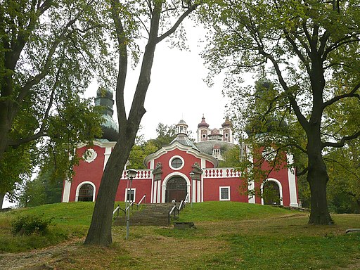
The Calvary is located on the Scharfenberg, a 727 meters high volcanic hill. It was built between 1744 and 1751 at the initiative of the Jesuit father Perger Ferenc.
It has 3 churches and 22 chapels. The upper church is called "German church", the middle is called "Hungarian church" and the lower one is called "Slovak church", because the messes were conducted in these languages in them during indulgence. The Sacred Stairs are located in the middle church with 34 steps. The Calvary is special because 7 stations depict the passion of the Christ, while 7 stations depict the sorrows of Virgin Marry.
Church of the Assumption of the Blessed Virgin Mary into Heaven
Kostol Nanebovzatia Panny Márie
Show on map
Visit
Church of the Assumption of the Blessed Virgin Mary into Heaven
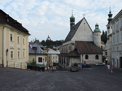
History
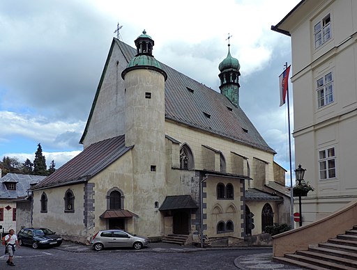
The church was built in the 1230s as a three-nave Romanesque church. King László IV of Hungary donated it to the Dominicans, who used it until 1563. At that time it was dedicated to St. Nicholas. The Lutherans used the church between 1575 and 1669. Afterwards the Jesuits acquired it. The main altar and the roof burned down during the uprising of Thököly Imre in 1679, and afterwards the Jesuits reconstructed the church between 1688 and 1689. In 1768 a Jesuit grammar school was opened in the former Dominican monastery. The Jesuit order was dissolved by the pope in 1773. The church was taken over by the parish, while the grammar school was taken over by the Piarists. After the fire in 1806 the church gained Classicist appearance and an Empire facade. In 1914 a new building was constructed for the grammar school in the northeastern part of the courtyard of the monastery. The old building of the monastery was demolished in 1933.
Saint Mary of the Snow Roman Catholic Church
Kostol Panny Márie Snežnej
Show on map
Visit
Saint Mary of the Snow Roman Catholic Church
History
The church was built in 1512 in Gothic style. It was used as a funeral parlor. It got a Baroque tower in the 18th century, which was destroyed in World War ll.
Lutheran Church
Evanjelický kostol
Show on map
Visit
Lutheran Church
History
The church was built between 1794 and 1796 in Zopf style without a tower. The altar picture was painted by the famous Hungarian painter Than Mór.
St. Elisabeth of Hungary Chapel
Kostol sv. Alžbety
Show on map
Visit
St. Elisabeth of Hungary Chapel
History
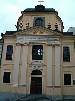
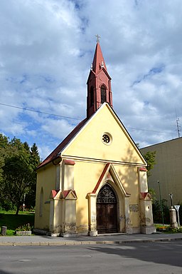
St Elisabeth of Hungary was the daughter of King Andrew II of Hungary. She donated a lot to the poor and sick people. The chapel was built in the middle of the 14th century in Gothic style. It served the spiritual needs of the town hospital next to it. It was incorporated into the Lower Gate of the town in 1574. In 1879 most of the church was demolished together with the town gate because of road construction. It was consecrated again as a chapel after a neo-Gothic reconstruction between 1894 an 1895.
former Neolog Synagogue
Židovská synagóga, Banská Štiavnica - Selmecbányai zsinagóga
Show on map
Visit
former Neolog Synagogue
History
The synagogue was built in 1893.
Public buildings
Town Hall
Mestský úrad
Show on map
Visit
Town Hall
History
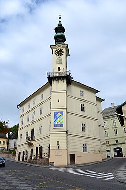
It was built in the 16th century. It gained its current form between 1787 and 1788, the tower was also added at that time. The hands of the clock are interchanged. The short one indicates the minutes, while the long one indicates the hours. According to the legend the merchants crossing the town weren't willing to contribute to the construction of the clock tower, and because of this, the burghers of Selmecbánya decided to swap the hands of the clock, so that the merchants couldn't read the exact time.
Chamber Courtyard, Kammerhof, Museum of Mining
Múzeum Kammerhof
Originally:
public administration
Show on map
Visit
Chamber Courtyard, Kammerhof, Museum of Mining
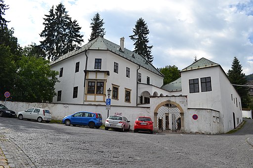
History
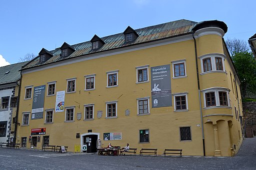
It was created by integrating a couple of Gothic houses in 1550. In the middle of the 16th century the seat of the Mining Chamber moved from Besztercebánya to Selmecbánya. It was engaged in controlling the extraction of the ores and in collecting the "urbura", the mining tax. In 1598 the Habsburg emperor established the Office of the Count of the Mining Chamber, which had its seat in Selmecbánya. lt controlled the mines, the mints, the estate of the mining chamber and the forests.
Later it was a mining office, which supervised the mines, forges and mints. Now it is the main building of the Museum of Mining.
Hellenbach House, Mineral Exhibition of the Museum of Mining and the Michael Mine Tunnel
Informačné centrum Banská Štiavnica
Originally:
public administration, university / college
Show on map
Visit
Hellenbach House, Mineral Exhibition of the Museum of Mining and the Michael Mine Tunnel
History
The house was built in the 15th century. It was owned by Baron Hellenbach Gottfried János (1659-1728), the owner of mines and breweries, from the end of the 17th century. He was also the doctor of Emperor Leopold I and later he became the follower and doctor of Prince Rákóczi Ferenc II, the leader of the Hungarian War of Independence between 1703 and 1711. He bore the title Count of the Mining Chamber during the War of Independence.
The building was the seat of the Mining Court (Berggericht) between 1792 and 1852. Between 1854 and 1859 it was the seat of the Mining District. From 1860 to 1900 the third faculty of the Academy of Mining occupied the building. The 76 meters-long Michael-tunnel, which can be visited by tourists, opens from its courtyard. The Academy of Mining was established in 1762 and the education started in 1764. It was the first academy of mining in the world. The Polytechnique in Paris was established in 1795 on the model of the Academy of Selmecbánya.
Cultural facilities
Zsembery House or Marschalkó House
Žemberovský dom
Originally:
university / college, parish
Show on map
Visit
Zsembery House or Marschalkó House
History
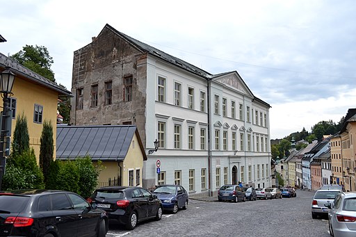
The house was created in the 16th century by joining two Gothic houses. It gained its current Classicist appearance in 1803 in a reconstruction according to the plans of J. Thaller.
It was originally a parish building, and later between 1808 and 1841 it was the seat of the newly established Scholl of Forestry.
It was the center of the students' community activities. At the beginning of the 1860s the "Szittnya Club" was established here. It was one of the first tourist associations of Europe. It was named after Mount Szitnya, which is the highest peak of the Mountain of Selmec with its height of 1011 meters. On November 2, 1872 at midnight the Hungarian Society was also established here. Balls and other events were held in the building as well.
Lutheran Lyceum
Show on map
Visit
Lutheran Lyceum
History
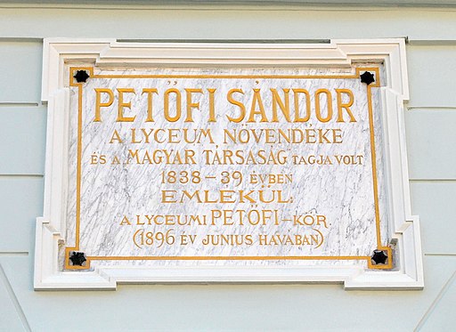
The Lutheran lyceum was established in the Reform Era of Hungary. The building was constructed between 1827 and 1830 in Classicist style on the location of the former building of the lyceum. In 1864 the building donated by the Kachelmann family was attached to it. Petőfi Sándor, the great poet of the Hungarian Revolution and War of Independence in 1848, attended the lyceum between 1838 and 1839. He has a memorial plaque on the wall of the building. Petőfi failed in Hungarian history because of his Slovak teacher, who couldn't even speak in Hungarian and who hated the Hungarians because of his Panslavic ideas. He hated Petőfi even more because, he also had Slavic ascendants. Afterwards his father refused to support Petőfi any longer. The Hungarian writer Mikszáth Kálmán also learned in the lyceum.
Krecsmáry House
Originally:
university / college
Show on map
Visit
Krecsmáry House
History
Nikolaus Joseph von Jackuin, a pioneer of experimental chemistry, started educating chemistry and mineralogy in the building in 1764. It was the first building of the Academy of Mining. The Academy of Mining was established in 1762 and the education started in 1764. It was the first academy of mining in the world. The Polytechnique in Paris was established in 1795 on the model of the Academy of Selmecbánya.
Fritz House
Originally:
university / college, inn/pub
Currently:
public archives
Show on map
Visit
Fritz House
History
The house was named after its original owner Leopold Fritz von Friedenlieb, who was a mine owner. This was the main building of the Academy of Mining, where the rector's office was located. There was also a council chamber and a library in the building and it hosted the Faculty of Engineering as well.
The Academy leased the building from 1829 and in 1885 they purchased it. Afterwards it was reconstructed according to the plans of Schulek Frigyes. The education of mining took place in the building until the construction of the new Palace of Mining and Metallurgy was finished. The ground floor of the building was occupied by the Molnár Inn, where the Hungarian Society also held its gatherings.
Buildings of the former Academy of Mining and Forestry
Stredná priemyselná škola Samuela Mikovíniho
Originally:
university / college
Show on map
Visit
Buildings of the former Academy of Mining and Forestry
History
The Palace of Forestry was built between 1885 and 1890 (Akademická 341, GPS: 48.459637, 18.899201). The Palace of Mining and Metallurgy was built in 1900, and the Palace of Chemistry was built in 1912.
Belházy House
Belházyovský dom
Originally:
university / college
Show on map
Visit
Belházy House
History
The house was built in Renaissance style in 1616 by the mine operator Eggstein Zsigmond von Ehrenegg. The house was later named after the judge of Selmecbánya (Belházy). In 1770 the Academy of Mining purchased the building. It became the chemical laboratory of the academy and Giovanni Antonio Scopoli started educating chemistry and metallurgy in it. The education continued in the building until 1900.
Arboretum, Garden of Feistmantel
Arborétum Kysihýbeľ
Visit
Arboretum, Garden of Feistmantel
History
The arboretum was established in 1900 by the assistant of the Academy of Forestry in Selmecbánya. It has a territory of 7.73 hectares.
Betlehem
Banskoštiavnický betlehem
Show on map
Visit
Betlehem
History
The museum presents the gold and silver mining and processing, the coin minting and the attractions of the town in reduced form.
Commerce, industry, hospitality
Jónás House, former Deer Tavern
Originally:
hotel / tavern / guesthouse
Currently:
restaurant / confectionery / café
Show on map
Visit
Jónás House, former Deer Tavern
History
It was once a tavern, Emperor Joseph II stayed in it in 1783. The students newly enrolled in the schools of Selmecbánya started to get to know the town here. In 1787 the famous mineralogist Jónás József was born here. The wall of the Gothic building is decorated by Renaissance frescos.
former Metropol Hotel
Show on map
Visit
former Metropol Hotel
History
There is a direct access from the hotel's cellar to the tunnels of the mines. The infamous inn that was addressed "To the grapes" was located in the building.
Szitnyai House
Note:
Elementary school of art.
Show on map
Visit
Szitnyai House
History
The house was built in the 16th century. At the turn of the 20th century it was owned by Szitnyai József, who was the mayor of Selmecbánya and also a scientist. The inn addressed "To the golden mining lampion" (Zum goldenen Grubenlicht) was located on the ground floor of this building.
former Tobacco Factory
Show on map
Visit
former Tobacco Factory
History
The enormous building of the Hungarian Royal Tobacco Factory was built between 1870 and 1871 on the place where once the fortress-like Rubigall castle and estate stood. Around 1880 1.200 workers made 60-70 million cigars by hand annually. (http://dohanymuzeum.hu/selmecbanyai-dohanygyar)
Glanzenberg Mine Tunnel
Štôlňa Glanzenberg
Show on map
Visit
Glanzenberg Mine Tunnel
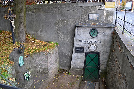
History
It is a mining tunnel, which can be visited by tourists. It is operated by the Museum of Mining. According to some opinions it is from the 14th century. The tunnel was mentioned for the first time in 1560.
Open Air Museum of Mining, Bertalan Mine Tunnel
Slovenské banské múzeum - Banské múzeum v prírode
Show on map
Visit
Open Air Museum of Mining, Bertalan Mine Tunnel
History
Starting from the 17th century Bertalan-tunnel a one hour tour can be taken in protective suit in the labyrinth of the mines of Selmecbánya. The length of the tour is 1,300 meters and it is 45 meters under the surface at its deepest point.
Town infrastructure
Old Castle
Starý Zámok
Originally:
castle / fortification
Show on map
Visit
Old Castle
History
It stands on the side of Mount Paradise. The church was built by the Templars in the 13th century in Romanesque style. According to the legend the master of the Templars got tempted by the beauty of the daughter of the lord of a nearby castle. He invited her and after he raped her, he had her and her companions killed to conceal his sin. But a young and conscientious Templar told the father what happened. He let the army of the lord into the Templar fortress during a feasting and they cut down all the Templars, which ended their rule.
The church was later acquired by the Dominicans. The Chapel of St. Michael stands next to it. The church was reconstructed in Gothic style in the 16th century. Between 1546 and 1559 the church was turned into a fort against the Turks. The large bell tower was built in the 17th century. The memorial of the Hungarian War of Independence between 1848 and 1849 was moved to the castle after the Czechoslovak invasion at the end of World War I.
New Castle or Girl's Castle
Nový Zámok
Originally:
castle / fortification
Note:
Exhibition of Hungarian-Turkish war, portrait gallery of the Koháry family.
Show on map
Visit
New Castle or Girl's Castle
History
It hosts an exhibition of the Hungarian-Turkish wars and there is also a beautiful panorama from the building. The castle was built between 1564 and 1571 against the Turks. It was protected by 24 Italian cannons. They raised a black flag as the enemy approached.
According to the legend the extremely wealthy Rössel Borbála had the castle built because she couldn't stand seeing the gallows pole of the town, which was standing in its place. She was called "witch of the Girl's Castle" because of her conceit and prodigal lifestyle. She was known for her beauty, but she rejected every marriage proposals. Her friends warned her of her prodigality but she cast her ring into the water of the Selmec brook saying that her wealth is as sure as that ring was lost forever. Her ring was later found in the guts of a fish and Borbála died as a poor woman. On her funeral a wind storm arose, which drove away the people and her body was torn apart by dogs.
Knocker
Čajovňa Klopačka
Currently:
restaurant / confectionery / café
Show on map
Visit
Knocker
History
The building of the Knocker was built in 1681 in Renaissance and Baroque style. It was the indispensable part of the old mining towns. lt called the miners to work at two o'clock in the morning and it was also sounded on funerals.
After arriving to Selmecbánya, General Bottyán the Blind recruited 1,000 miners to the army of Prince Rákóczi Ferenc II from the surrounding area with the sound of the Knocker during the Hungarian War of Independence (1703-1711).
In January 1849 the Hungarian General Görgei Artúr called the miners to make the tunnels under Mount Szkalka suitable for his army to march through also with the sound of the Knocker. This way Görgey could reach the pass of Sturec two days earlier and could unite with the army of Klapka György. This made possible the launching of the glorious Spring Campaign that liberated most of Hungary from the Imperial rule during the Hungarian War of Independence between 1848 and 1849.
The building is a tea house at the moment.
Hegybánya Gate or Szélakna Gate
Piargska brána
Show on map
Visit
Hegybánya Gate or Szélakna Gate
History
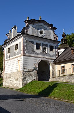
The town gate was built in 1554 in Renaissance style to defend the town against the Turks. The gate was reconstructed in Baroque style in the first half of the 18th century. The statue of St. Florian stands in a niche in its facade. Next to the gate the remains of the town wall and one of its bastions can be seen. The other medieval gates of the town (the gates of Szentantal, Bélabánya and Bakabánya) have already been demolished.
Corner of the Sheepish
Show on map
Visit
Corner of the Sheepish
History
It is at the corner of the Fritz House, where the Terrace meets the former Kossuth square. It was the main meeting place of the students of the Mining Academy. It got its name after the students who were watching the girls from there.
Terrace
Show on map
Visit
Terrace
History
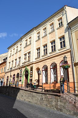
The terrace runs along one side of the main street and there are shops along it.
Private buildings
Flemming House
Originally:
house, coin mint
Show on map
Visit
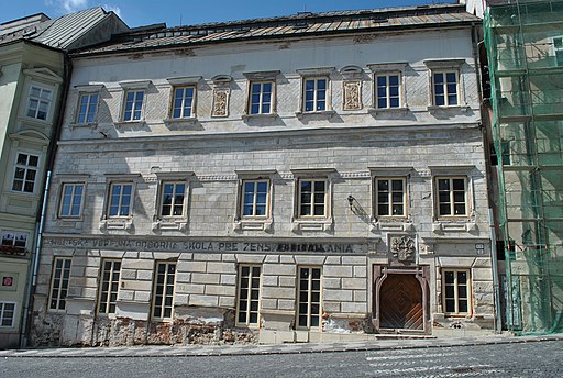
Flemming House
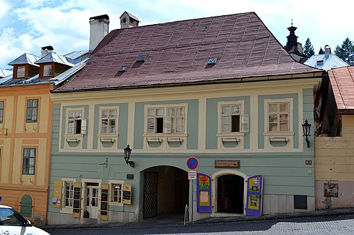
History
The building was created in the 16th century by merging three Gothic houses. The gold coins of Körmöcbánya were minted here from 1598 for one and a half years.
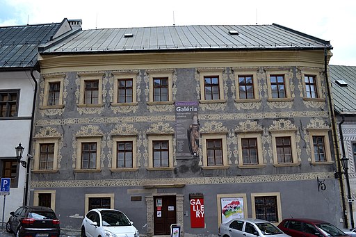
Josef Kollár Gallery
Galéria Jozefa Kollára
Show on map
Visit
Josef Kollár Gallery
History
The gallery is situated in a medieval burgher's house on Trinity square.
Rubigall House
Show on map
Visit
Rubigall House
History
The house was built in 1538 in Gothic style for the Rubigall family. It was once the seat of the Bank of Selmec and of the mining archives.
Mikovinyi House
Mikoviniho dom
Show on map
Visit
Mikovinyi House
History
It was the house of Mikovinyi Sámuel, who was an engineer and a Renaissance man. Several water reservoirs in the area were built at his recommendation and in 1735 he became the first teacher of the mining school that later became the Academy of Mining.
Joerges House
Joergesov dom
Originally:
house, printing press
Currently:
restaurant / confectionery / café
Show on map
Visit
Joerges House
History
The Renaissance house was built in the first half of the 16th century. In the 19th century it was owned by the mine doctor Heinrich Mihály. From the beginning of the 20th century the printing press of Joerges Ágost occupied the building.
Memorials
Memorial of the Hungarian War of Independence between 1848 and 1849
Originally:
statue / memorial / relief
Currently:
statue / memorial / relief
Show on map
Visit
Memorial of the Hungarian War of Independence between 1848 and 1849
History
The statue was erected in 1899 in memory of the Hungarian War of Independence between 1848 and 1849. It was the artwork of Tóth András, the father of the Hungarian poet Tóth Áprád. Originally it stood on Kammerhof Street next to the Kachelmann Tavern, but in 1919 it was vandalized and torn down by the Czechoslovak invaders. Now a Soviet memorial occupies its place. The statue was reerected in the courtyard of the castle in 2002.
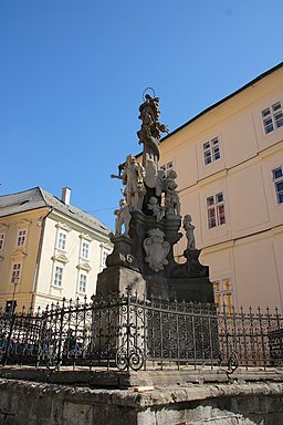
Immaculata Statue
Súsošie Panny Márie
Originally:
statue / memorial / relief
Currently:
statue / memorial / relief
Show on map
Visit
Immaculata Statue
History
The statue was erected in 1758. It is the artwork of Franz Rössner. It is adorned by the statues of Michael, Gabrial and Rafael archangels.
Trinity Statue
Originally:
statue / memorial / relief
Currently:
statue / memorial / relief
Show on map
Visit
Trinity Statue
History
The statue was raised between 1755 and 1756 out of gratitude for the passing of the great plague in 1710.
Plaque of Petőfi Sándor
Show on map
Visit
Plaque of Petőfi Sándor
History
The plaque was placed on the wall of the Lutheran lyceum in 1896. Petőfi Sándor, the great poet of the Hungarian Revolution and War of Independence in 1848, attended the lyceum between 1838 and 1839. He has a memorial plaque on the wall of the building. Petőfi failed in Hungarian history because of his Slovak teacher, who couldn't even speak in Hungarian and who hated the Hungarians because of his Panslavic ideas.
Museums and Galleries
Old Castle
Starý Zámok
Originally:
castle / fortification
Show on map
Visit
Old Castle
History
It stands on the side of Mount Paradise. The church was built by the Templars in the 13th century in Romanesque style. According to the legend the master of the Templars got tempted by the beauty of the daughter of the lord of a nearby castle. He invited her and after he raped her, he had her and her companions killed to conceal his sin. But a young and conscientious Templar told the father what happened. He let the army of the lord into the Templar fortress during a feasting and they cut down all the Templars, which ended their rule.
The church was later acquired by the Dominicans. The Chapel of St. Michael stands next to it. The church was reconstructed in Gothic style in the 16th century. Between 1546 and 1559 the church was turned into a fort against the Turks. The large bell tower was built in the 17th century. The memorial of the Hungarian War of Independence between 1848 and 1849 was moved to the castle after the Czechoslovak invasion at the end of World War I.
New Castle or Girl's Castle
Nový Zámok
Originally:
castle / fortification
Note:
Exhibition of Hungarian-Turkish war, portrait gallery of the Koháry family.
Show on map
Visit
New Castle or Girl's Castle
History
It hosts an exhibition of the Hungarian-Turkish wars and there is also a beautiful panorama from the building. The castle was built between 1564 and 1571 against the Turks. It was protected by 24 Italian cannons. They raised a black flag as the enemy approached.
According to the legend the extremely wealthy Rössel Borbála had the castle built because she couldn't stand seeing the gallows pole of the town, which was standing in its place. She was called "witch of the Girl's Castle" because of her conceit and prodigal lifestyle. She was known for her beauty, but she rejected every marriage proposals. Her friends warned her of her prodigality but she cast her ring into the water of the Selmec brook saying that her wealth is as sure as that ring was lost forever. Her ring was later found in the guts of a fish and Borbála died as a poor woman. On her funeral a wind storm arose, which drove away the people and her body was torn apart by dogs.
Chamber Courtyard, Kammerhof, Museum of Mining
Múzeum Kammerhof
Originally:
public administration
Show on map
Visit
Chamber Courtyard, Kammerhof, Museum of Mining
History
It was created by integrating a couple of Gothic houses in 1550. In the middle of the 16th century the seat of the Mining Chamber moved from Besztercebánya to Selmecbánya. It was engaged in controlling the extraction of the ores and in collecting the "urbura", the mining tax. In 1598 the Habsburg emperor established the Office of the Count of the Mining Chamber, which had its seat in Selmecbánya. lt controlled the mines, the mints, the estate of the mining chamber and the forests.
Later it was a mining office, which supervised the mines, forges and mints. Now it is the main building of the Museum of Mining.
Hellenbach House, Mineral Exhibition of the Museum of Mining and the Michael Mine Tunnel
Informačné centrum Banská Štiavnica
Originally:
public administration, university / college
Show on map
Visit
Hellenbach House, Mineral Exhibition of the Museum of Mining and the Michael Mine Tunnel
History
The house was built in the 15th century. It was owned by Baron Hellenbach Gottfried János (1659-1728), the owner of mines and breweries, from the end of the 17th century. He was also the doctor of Emperor Leopold I and later he became the follower and doctor of Prince Rákóczi Ferenc II, the leader of the Hungarian War of Independence between 1703 and 1711. He bore the title Count of the Mining Chamber during the War of Independence.
The building was the seat of the Mining Court (Berggericht) between 1792 and 1852. Between 1854 and 1859 it was the seat of the Mining District. From 1860 to 1900 the third faculty of the Academy of Mining occupied the building. The 76 meters-long Michael-tunnel, which can be visited by tourists, opens from its courtyard. The Academy of Mining was established in 1762 and the education started in 1764. It was the first academy of mining in the world. The Polytechnique in Paris was established in 1795 on the model of the Academy of Selmecbánya.
Josef Kollár Gallery
Galéria Jozefa Kollára
Show on map
Visit
Josef Kollár Gallery
History
The gallery is situated in a medieval burgher's house on Trinity square.
Arboretum, Garden of Feistmantel
Arborétum Kysihýbeľ
Visit
Arboretum, Garden of Feistmantel
History
The arboretum was established in 1900 by the assistant of the Academy of Forestry in Selmecbánya. It has a territory of 7.73 hectares.
Glanzenberg Mine Tunnel
Štôlňa Glanzenberg
Show on map
Visit
Glanzenberg Mine Tunnel
History
It is a mining tunnel, which can be visited by tourists. It is operated by the Museum of Mining. According to some opinions it is from the 14th century. The tunnel was mentioned for the first time in 1560.
Open Air Museum of Mining, Bertalan Mine Tunnel
Slovenské banské múzeum - Banské múzeum v prírode
Show on map
Visit
Open Air Museum of Mining, Bertalan Mine Tunnel
History
Starting from the 17th century Bertalan-tunnel a one hour tour can be taken in protective suit in the labyrinth of the mines of Selmecbánya. The length of the tour is 1,300 meters and it is 45 meters under the surface at its deepest point.
Betlehem
Banskoštiavnický betlehem
Show on map
Visit
Betlehem
History
The museum presents the gold and silver mining and processing, the coin minting and the attractions of the town in reduced form.
{"item":"town","set":{"mapcenter":{"lat":"48.4587430000","long":"18.8932970000"},"townlink":"selmecbanya-banska-stiavnica","town":{"townId":33,"active":1,"name_HU":"Selmecb\u00e1nya","name_LO":"Bansk\u00e1 \u0160tiavnica","name_GE":"Schemnitz","name_LT":"Schemnicium","seolink":"selmecbanya-banska-stiavnica","listorder":9,"oldcounty":5,"country":2,"division":6,"altitude":"600","gps_lat":"48.4587430000","gps_long":"18.8932970000","population":10,"hungarian_2011":0.34,"population_1910":15185,"hungarian_1910":41.75,"german_1910":0,"slovak_1910":54.93,"romanian_1910":0,"rusin_1910":0,"serbian_1910":0,"croatian_1910":0,"slovenian_1910":0,"coatofarms":"","coatofarms_ref":"","picture":"\u003Ca title=\u0022Ralle7 \/ CC BY-SA (https:\/\/creativecommons.org\/licenses\/by-sa\/3.0)\u0022 href=\u0022https:\/\/commons.wikimedia.org\/wiki\/File:Bansk%C3%A1_%C5%A0tiavnica_im_Herbst.JPG\u0022\u003E\u003Cimg width=\u0022512\u0022 alt=\u0022Bansk\u00e1 \u0160tiavnica im Herbst\u0022 src=\u0022https:\/\/upload.wikimedia.org\/wikipedia\/commons\/thumb\/8\/84\/Bansk%C3%A1_%C5%A0tiavnica_im_Herbst.JPG\/512px-Bansk%C3%A1_%C5%A0tiavnica_im_Herbst.JPG\u0022\u003E\u003C\/a\u003E","picture_ref":"\u003Ca href=\u0022https:\/\/commons.wikimedia.org\/wiki\/File:Bansk%C3%A1_%C5%A0tiavnica_im_Herbst.JPG\u0022 title=\u0022via Wikimedia Commons\u0022\u003ERalle7\u003C\/a\u003E \/ \u003Ca href=\u0022https:\/\/creativecommons.org\/licenses\/by-sa\/3.0\u0022\u003ECC BY-SA\u003C\/a\u003E","georegion":"Selmec Mountains","river":"Selmec Brook","description":" The town was one of the most important mining towns of Hungary, its silver and gold mines were among the most significant. Stephen I of Hungary already minted coin from the silver mined here. The settlement was destroyed during the Mongol Invasion and was repopulated by German miners. Hungary gave one quarter of the global silver production at that time. King Charles I of Hungary started minting silver coins called garas, which kept a constant value, in 1329. The town's defenses were built during the 1500s because of the Turkish threat, but the town was never occupied by them. The world's first Mining Academy was established here in 1770, which became the model for the Polytechnique in Paris. Selmecb\u00e1nya was the third largest town of Hungary at that time. With the decline of mining, it became an important school town, and the Academy of Mining and Metallurgy expanded with a faculty of forest engineering. All this ended with the Czechoslovak occupation in 1919, when the Academy had to move to the territory of present-day Hungary. Several mining tunnels and a mining museum provide an insight into the town\u2019s mining past.","nameorigin":"","history":"#1|@#3|@11th century|King Stephen I of Hungary minted silver coins using the silver mined here. The mint was located in Esztergom until the 13th century. Denar and obol (obulus) were minted. The obol had half the value of a denar.@1075|The silver mining of Selmecb\u00e1nya was mentioned for the first time.@1217|It was mentioned by the names \u0022Bana, Banya\u0022.@13th century|The chirch of Virgin Mary was built.@#5|@1275|The monks of the Dominican Order built their church dedicated to St. Nicholas.@1238|King B\u00e9la IV of Hungary made Selmecb\u00e1nya a free royal town.@before 1241|King B\u00e9la IV made a contract with a German mining company, which made the deeper silver veins exploitable by the use of a water extraction machine.@autumn 1241|The town was destroyed by the Mongol invaders.@after 1242|After the Mongol invasion Bavarian and Saxon migrants were settled down, who founded the settlement in its current location.@#6|@early 14th century|The Hungarian oligarch Cs\u00e1k M\u00e1t\u00e9 ruled the settlement.@1321|After the death of Cs\u00e1k M\u00e1t\u00e9, King Charles I of Hungary occupied the town.@1325|King Charles I of Hungary started to produce gold florins in the mint of the town. The king founded other Minting Chambers besides Esztergom and Buda. The Hungarian mints, which gained their fame in the following centuries, were established at that time. There were altogether 10 mints in the country (Buda, Kolozsv\u00e1r, Nagyb\u00e1nya, K\u00f6rm\u00f6cb\u00e1nya etc.).@1440|After the death of King Albert of the House of Habsburg, the Estates of Hungary elected the Polish Ul\u00e1szl\u00f3 to the throne. Elisabeth, the widow queen, in order to secure the throne for L\u00e1szl\u00f3, her baby boy, called in the Czech Hussite mercenary leader Jan Jiskra. She gave him the title \u0022Captain of the Mining Towns and Kassa\u0022, and gave him the castle of Z\u00f3lyom.@1440-1441|The Czech Hussites soon occupied much of northern Hungary. They reinforced the castles and turned them into bandit lairs. They were pillaging everywhere and large areas became uninhabited. They wiped out the local German and Hungarian population, who were replaced by Czech and other Slavic settlers. The Czech Hussite devastation largely contributed to the Slavicisation of northern Hungary (now Slovakia).@1442|The Hussite captain of Selmecb\u00e1nya attacked Eger, the town of Bishop Rozgonyi Simon, who supported King Ul\u00e1szl\u00f3 I. The Czechs looted the town but did not dare to attack the castle. The Hussites were pursued by the army of the bishop and of Baron Czudar Jakab. In the forest near Sz\u00f6l\u00f6ske the Hussite commander Talafuz was captured. As a revenge the bishop occupied Selmecb\u00e1nya and looted and burned its houses.@1443|A terrible earthquake shook the town.@1462|At the end of the war that King Matthias of Hungary had waged against the Hussites since 1458, Jiskra swore loyalty to the king and handed over the castles he still held. Afterwards Jiskra fought in the service of King Matthias until his death.@1526|The king's military quelled the uprising of the miners.@#8|@#11|@1546-59|After the Turks occupied Buda, the Gothic parish church was transformed into a fortified church encircled by walls. This is the so called Old Castle.@1564 \u2013 71|The New Castle, also called the Daughter Castle, was constructed against the Turks. It functioned as a fire tower since the 18th century.@1575|The Turks occupied the castles of Somosk\u0151, K\u00e9kk\u0151 and Div\u00e9ny, so they got dangerously close to the town. The direct threat ended in 1593, when the castles of N\u00f3gr\u00e1d County were taken back.@#13|@1605|Bocskai Istv\u00e1n occupied the town peacefully.@#14|@#15|@1619|Prince Bethlen G\u00e1bor of Transylvania captured Selmecb\u00e1nya without a fight. The Isp\u00e1n of Z\u00f3lyom was at that time the Habsburg-friendly Esterh\u00e1zy Mikl\u00f3s.@early June, 1621|Selmecb\u00e1nya surrendered to the Imperials.@July 5, 1621|After the victory of Egry Istv\u00e1n at Z\u00f3lyom, the town surrendered to Prince Bethlen G\u00e1bor again.@#16|@1627|Gunpowder was used in mining in Selmecb\u00e1nya for the first time in the world.@#17|@early April 1644|The mining towns surrendered to Prince R\u00e1k\u00f3czi Gy\u00f6rgy I of Transylvania for a short time.@#18|@#21|@October 10, 1678|After the arrival of the kuruc army of Th\u00f6k\u00f6ly Imre, the town surrendered willingly. But after Th\u00f6k\u00f6ly's defeat at Barsszentkereszt on the 1st of November, they had to give up Beszterceb\u00e1nya.@late April 1679|Father J\u00f3zsa Istv\u00e1n, who frequently switched sides, attacked and looted Selmecb\u00e1nya. Soon he sided with the Imperials, and on 21th of October the kurucs surrounded him at T\u00e1lya. He was caught and beheaded for his betrayal.@#22|@September 1682|After the united armies of Th\u00f6k\u00f6ly Imre kuruc leader and the Turks captured F\u00fclek, the Imperial army of Caprara, consisting of mainly fresh recruits, retreated to Trencs\u00e9n. Th\u00f6k\u00f6ly occupied Z\u00f3lyom and sent G\u00f6rgey Boldizs\u00e1r to capture the mining towns. They returned with rich booty.@November 19, 1682|Th\u00f6k\u00f6ly Imre signed a truce with the Imperials. The ruruc rule extended to the Garam River, but the mining towns were given back to the Emperor in exchange for a monthly tribute of 3,000 gold florins.@July 1, 1683|The Imperial commander Schulz received orders to empty the mining towns and retreat to the defense of Vienna, because a huge Turkish army was on the way to take it.@#23|@autumn 1683|After the Turkish defeat at Vienna, the town was again under Habsburg rule.@#24|@#25|@#27|@September 1703|The kuruc cavalry of Ocskay occupied the town. They had to abandon the town after the lost battle at L\u00e9va on the 31st of October for a short time. But after they won the battle at Z\u00f3lyom on the 15th of November, Selmecb\u00e1nya was again occupied by the kuruc generals, Bercs\u00e9nyi Mikl\u00f3s and K\u00e1rolyi S\u00e1ndor.@October 1708|After the lost battle at Trencs\u00e9n, the kuruc insurgents abandoned the town and the Imperial army of General Heister matched in.@August 23, 1709|The kuruc general Botty\u00e1n J\u00e1nos fought a bloody battle at the ramparts of Selmecb\u00e1nya, and they even captured the Imperial General Tollet, but they could not retake the town.@1735|An institution for training mining officers was opened.@1770|The world's first Mining Academy was founded.@1782|It was the third largest town of Hungary with its population of 23,192 after Pozsony and Debrecen.@1786|The town was granted the right to hold country fairs.@second half of the 19th century|The mining declined, Selmecb\u00e1nya became a school town.@1807|The Institution of Forest Engineering was created.@#28|@#30|@1873|A narrow-gauge railway was built between Garamberzence and Selmecb\u00e1nya.@#31|@#32|@January 3, 1919|The Czechoslovaks invaded Selmecb\u00e1nya. After the Czechoslovak invasion the educational institutions had to be moved to Sopron, Hungary.@#34|@June 6, 1919|The army of the Hungarian Soviet Republic liberated Selmecb\u00e1nya from the Czechoslovak invaders.@#36|@#38|@#41|@March 7, 1945|The Soviets invaded Selmecb\u00e1nya.@#42|@1949|The faculties of mining and metallurgy were moved from Sopron to Miskolc, and the University of Miskolc was founded. The faculty of forest engineering remained in Sopron.@#44|&"},"sights":[{"sightId":642,"townId":33,"active":2,"name_LO":"Star\u00fd Z\u00e1mok","address":"Staroz\u00e1mock\u00e1 11, 969 01 Bansk\u00e1 \u0160tiavnica","mapdata":"1|327|345","gps_lat":"48.4596340000","gps_long":"18.8912350000","religion":0,"oldtype":"22","newtype":"98","homepage":"https:\/\/www.muzeumbs.sk\/sk\/stary-zamok","openinghours":"","muemlekemlink":"https:\/\/www.muemlekem.hu\/hatareset\/Ovar-Selmecbanya-133","csemadoklink":"http:\/\/emlekhelyek.csemadok.sk\/emlekhelyek\/ovar\/\n","picture":"\u003Ca title=\u0022Ladislav Luppa \/ CC BY-SA (https:\/\/creativecommons.org\/licenses\/by-sa\/4.0)\u0022 href=\u0022https:\/\/commons.wikimedia.org\/wiki\/File:Bansk%C3%A1_%C5%A0tiavnica_-_Star%C3%BD_z%C3%A1mok_(1).jpg\u0022\u003E\u003Cimg width=\u0022512\u0022 alt=\u0022Bansk\u00e1 \u0160tiavnica - Star\u00fd z\u00e1mok (1)\u0022 src=\u0022https:\/\/upload.wikimedia.org\/wikipedia\/commons\/thumb\/4\/41\/Bansk%C3%A1_%C5%A0tiavnica_-_Star%C3%BD_z%C3%A1mok_%281%29.jpg\/512px-Bansk%C3%A1_%C5%A0tiavnica_-_Star%C3%BD_z%C3%A1mok_%281%29.jpg\u0022\u003E\u003C\/a\u003E","picture_ref":"\u003Ca href=\u0022https:\/\/commons.wikimedia.org\/wiki\/File:Bansk%C3%A1_%C5%A0tiavnica_-_Star%C3%BD_z%C3%A1mok_(1).jpg\u0022 title=\u0022via Wikimedia Commons\u0022\u003ELadislav Luppa\u003C\/a\u003E \/ \u003Ca href=\u0022https:\/\/creativecommons.org\/licenses\/by-sa\/4.0\u0022\u003ECC BY-SA\u003C\/a\u003E","name":"Old Castle","seolink":"old-castle","note":"Castle museum.","history":"It stands on the side of Mount Paradise. The church was built by the Templars in the 13th century in Romanesque style. According to the legend the master of the Templars got tempted by the beauty of the daughter of the lord of a nearby castle. He invited her and after he raped her, he had her and her companions killed to conceal his sin. But a young and conscientious Templar told the father what happened. He let the army of the lord into the Templar fortress during a feasting and they cut down all the Templars, which ended their rule.@The church was later acquired by the Dominicans. The Chapel of St. Michael stands next to it. The church was reconstructed in Gothic style in the 16th century. Between 1546 and 1559 the church was turned into a fort against the Turks. The large bell tower was built in the 17th century. The memorial of the Hungarian War of Independence between 1848 and 1849 was moved to the castle after the Czechoslovak invasion at the end of World War I."},{"sightId":643,"townId":33,"active":2,"name_LO":"Nov\u00fd Z\u00e1mok","address":"Novoz\u00e1mock\u00e1 22, 969 01 Bansk\u00e1 \u0160tiavnica","mapdata":"1|612|675","gps_lat":"48.4557980000","gps_long":"18.8961390000","religion":0,"oldtype":"22","newtype":"98","homepage":"https:\/\/www.muzeumbs.sk\/sk\/novy-zamok","openinghours":"","muemlekemlink":"https:\/\/www.muemlekem.hu\/hatareset\/Ujvar--Leanyvar--Selmecbanya-134","csemadoklink":"http:\/\/emlekhelyek.csemadok.sk\/emlekhelyek\/ujvar-leanyvar\/\n","picture":"\u003Ca title=\u0022Ladislav Luppa \/ CC BY-SA (https:\/\/creativecommons.org\/licenses\/by-sa\/4.0)\u0022 href=\u0022https:\/\/commons.wikimedia.org\/wiki\/File:Bansk%C3%A1_%C5%A0tiavnica_-_Nov%C3%BD_z%C3%A1mok_-a.jpg\u0022\u003E\u003Cimg width=\u0022512\u0022 alt=\u0022Bansk\u00e1 \u0160tiavnica - Nov\u00fd z\u00e1mok -a\u0022 src=\u0022https:\/\/upload.wikimedia.org\/wikipedia\/commons\/thumb\/7\/77\/Bansk%C3%A1_%C5%A0tiavnica_-_Nov%C3%BD_z%C3%A1mok_-a.jpg\/512px-Bansk%C3%A1_%C5%A0tiavnica_-_Nov%C3%BD_z%C3%A1mok_-a.jpg\u0022\u003E\u003C\/a\u003E","picture_ref":"\u003Ca href=\u0022https:\/\/commons.wikimedia.org\/wiki\/File:Bansk%C3%A1_%C5%A0tiavnica_-_Nov%C3%BD_z%C3%A1mok_-a.jpg\u0022 title=\u0022via Wikimedia Commons\u0022\u003ELadislav Luppa\u003C\/a\u003E \/ \u003Ca href=\u0022https:\/\/creativecommons.org\/licenses\/by-sa\/4.0\u0022\u003ECC BY-SA\u003C\/a\u003E","name":"New Castle or Girl's Castle ","seolink":"new-castle-or-girls-castle","note":"Exhibition of Hungarian-Turkish war, portrait gallery of the Koh\u00e1ry family.","history":"It hosts an exhibition of the Hungarian-Turkish wars and there is also a beautiful panorama from the building. The castle was built between 1564 and 1571 against the Turks. It was protected by 24 Italian cannons. They raised a black flag as the enemy approached.@According to the legend the extremely wealthy R\u00f6ssel Borb\u00e1la had the castle built because she couldn't stand seeing the gallows pole of the town, which was standing in its place. She was called \u0022witch of the Girl's Castle\u0022 because of her conceit and prodigal lifestyle. She was known for her beauty, but she rejected every marriage proposals. Her friends warned her of her prodigality but she cast her ring into the water of the Selmec brook saying that her wealth is as sure as that ring was lost forever. Her ring was later found in the guts of a fish and Borb\u00e1la died as a poor woman. On her funeral a wind storm arose, which drove away the people and her body was torn apart by dogs."},{"sightId":644,"townId":33,"active":1,"name_LO":"Kostol Nanebovzatia Panny M\u00e1rie","address":"Akademick\u00e1 329, 969 01 Bansk\u00e1 \u0160tiavnica","mapdata":"1|651|443","gps_lat":"48.4583950000","gps_long":"18.8965670000","religion":1,"oldtype":"1","newtype":"1","homepage":"http:\/\/banskastiavnica.fara.sk\/web\/index.php\/kostoly\/farsky-kostol","openinghours":"","muemlekemlink":"https:\/\/www.muemlekem.hu\/hatareset\/Nagyboldogasszony-templom-Selmecbanya-143","csemadoklink":"http:\/\/emlekhelyek.csemadok.sk\/emlekhelyek\/selmecbanyai-nagyboldogasszony-templom\/\r","picture":"\u003Ca title=\u0022Ladislav Luppa \/ CC BY-SA (https:\/\/creativecommons.org\/licenses\/by-sa\/4.0)\u0022 href=\u0022https:\/\/commons.wikimedia.org\/wiki\/File:Bansk%C3%A1_%C5%A0tiavnica_-_Kostol_Nanebovzatia_Panny_M%C3%A1rie_(1).jpg\u0022\u003E\u003Cimg width=\u0022256\u0022 alt=\u0022Bansk\u00e1 \u0160tiavnica - Kostol Nanebovzatia Panny M\u00e1rie (1)\u0022 src=\u0022https:\/\/upload.wikimedia.org\/wikipedia\/commons\/thumb\/9\/99\/Bansk%C3%A1_%C5%A0tiavnica_-_Kostol_Nanebovzatia_Panny_M%C3%A1rie_%281%29.jpg\/256px-Bansk%C3%A1_%C5%A0tiavnica_-_Kostol_Nanebovzatia_Panny_M%C3%A1rie_%281%29.jpg\u0022\u003E\u003C\/a\u003E","picture_ref":"\u003Ca href=\u0022https:\/\/commons.wikimedia.org\/wiki\/File:Bansk%C3%A1_%C5%A0tiavnica_-_Kostol_Nanebovzatia_Panny_M%C3%A1rie_(1).jpg\u0022 title=\u0022via Wikimedia Commons\u0022\u003ELadislav Luppa\u003C\/a\u003E \/ \u003Ca href=\u0022https:\/\/creativecommons.org\/licenses\/by-sa\/4.0\u0022\u003ECC BY-SA\u003C\/a\u003E","name":"Church of the Assumption of the Blessed Virgin Mary into Heaven","seolink":"church-of-the-assumption-of-the-blessed-virgin-mary-into-heaven","note":"","history":"The church was built in the 1230s as a three-nave Romanesque church. King L\u00e1szl\u00f3 IV of Hungary donated it to the Dominicans, who used it until 1563. At that time it was dedicated to St. Nicholas. The Lutherans used the church between 1575 and 1669. Afterwards the Jesuits acquired it. The main altar and the roof burned down during the uprising of Th\u00f6k\u00f6ly Imre in 1679, and afterwards the Jesuits reconstructed the church between 1688 and 1689. In 1768 a Jesuit grammar school was opened in the former Dominican monastery. The Jesuit order was dissolved by the pope in 1773. The church was taken over by the parish, while the grammar school was taken over by the Piarists. After the fire in 1806 the church gained Classicist appearance and an Empire facade. In 1914 a new building was constructed for the grammar school in the northeastern part of the courtyard of the monastery. The old building of the monastery was demolished in 1933."},{"sightId":645,"townId":33,"active":2,"name_LO":"Kostol sv. Katar\u00edny","address":"N\u00e1m. sv. Trojice 16\/12, 969 01 Bansk\u00e1 \u0160tiavnica","mapdata":"1|420|394","gps_lat":"48.4588270000","gps_long":"18.8929850000","religion":1,"oldtype":"1","newtype":"1","homepage":"http:\/\/banskastiavnica.fara.sk\/web\/index.php\/kostoly\/kostol-sv-katariny","openinghours":"","muemlekemlink":"https:\/\/www.muemlekem.hu\/hatareset\/Szent-Katalin-templom-Selmecbanya-139","csemadoklink":"http:\/\/emlekhelyek.csemadok.sk\/emlekhelyek\/szent-katalin-templom-selmecbanyan\/\n","picture":"\u003Ca title=\u0022Jan Starec \/ CC BY-SA (https:\/\/creativecommons.org\/licenses\/by-sa\/3.0)\u0022 href=\u0022https:\/\/commons.wikimedia.org\/wiki\/File:Kostol_sv._Katar%C3%ADny_-_panoramio.jpg\u0022\u003E\u003Cimg width=\u0022512\u0022 alt=\u0022Kostol sv. Katar\u00edny - panoramio\u0022 src=\u0022https:\/\/upload.wikimedia.org\/wikipedia\/commons\/thumb\/f\/f7\/Kostol_sv._Katar%C3%ADny_-_panoramio.jpg\/512px-Kostol_sv._Katar%C3%ADny_-_panoramio.jpg\u0022\u003E\u003C\/a\u003E","picture_ref":"\u003Ca href=\u0022https:\/\/commons.wikimedia.org\/wiki\/File:Kostol_sv._Katar%C3%ADny_-_panoramio.jpg\u0022 title=\u0022via Wikimedia Commons\u0022\u003EJan Starec\u003C\/a\u003E \/ \u003Ca href=\u0022https:\/\/creativecommons.org\/licenses\/by-sa\/3.0\u0022\u003ECC BY-SA\u003C\/a\u003E","name":"St. Catherine Roman Catholic Church ","seolink":"st-catherine-roman-catholic-church","note":"","history":"The church was built between 1443 and 1491 in late Gothic style. The western Renaissance hallway was built in 1555. It became the parish church at that time, because the former parish church of Our Lady was turned into a castle against the Turks (it is the Old Castle).@Above the portal the coats of arms of Hungary, Selmecb\u00e1nya and Rubigall P\u00e1l, who contributed a large sum to the construction of the church, can be seen. The church was used by the Lutherans from 1580 to 1672. In 1692 the church was acquired by the Jesuits, who turned the interior of the church into Baroque style in the 18th century. The Chapel of St. John of Nepomuk was added in 1776. At the end of the 19th century the interior was converted back to Gothic style. In 1900 two choirs were built and a new neo-Gothic organ was made in the workshop of the Riegel brothers in Budapest. The colored windows of the presbytery are from 1894 and stained glass windows of the side chapel are from 1907. The names of the donors are written on them in Hungarian."},{"sightId":646,"townId":33,"active":1,"name_LO":"Kostol Panny M\u00e1rie Sne\u017enej","address":"969 01 Bansk\u00e1 \u0160tiavnica","mapdata":"1|500|668","gps_lat":"48.4558850000","gps_long":"18.8941540000","religion":1,"oldtype":"1","newtype":"1","homepage":"","openinghours":"","muemlekemlink":"https:\/\/www.muemlekem.hu\/hatareset\/Havasboldogasszony-templom-Selmecbanya-144","csemadoklink":"http:\/\/emlekhelyek.csemadok.sk\/emlekhelyek\/havas-boldogasszony-frauenbergi-templom-selmecbanyan\/\r","picture":"\u003Ca title=\u0022Draceane \/ CC BY-SA (https:\/\/creativecommons.org\/licenses\/by-sa\/4.0)\u0022 href=\u0022https:\/\/commons.wikimedia.org\/wiki\/File:Bansk%C3%A1_%C5%A0tiavnica,_2018_(49).jpg\u0022\u003E\u003Cimg width=\u0022512\u0022 alt=\u0022Bansk\u00e1 \u0160tiavnica, 2018 (49)\u0022 src=\u0022https:\/\/upload.wikimedia.org\/wikipedia\/commons\/thumb\/c\/ce\/Bansk%C3%A1_%C5%A0tiavnica%2C_2018_%2849%29.jpg\/512px-Bansk%C3%A1_%C5%A0tiavnica%2C_2018_%2849%29.jpg\u0022\u003E\u003C\/a\u003E","picture_ref":"\u003Ca href=\u0022https:\/\/commons.wikimedia.org\/wiki\/File:Bansk%C3%A1_%C5%A0tiavnica,_2018_(49).jpg\u0022 title=\u0022via Wikimedia Commons\u0022\u003EDraceane\u003C\/a\u003E \/ \u003Ca href=\u0022https:\/\/creativecommons.org\/licenses\/by-sa\/4.0\u0022\u003ECC BY-SA\u003C\/a\u003E","name":"Saint Mary of the Snow Roman Catholic Church ","seolink":"saint-mary-of-the-snow-roman-catholic-church","note":"","history":"The church was built in 1512 in Gothic style. It was used as a funeral parlor. It got a Baroque tower in the 18th century, which was destroyed in World War ll."},{"sightId":647,"townId":33,"active":1,"name_LO":"Kostol sv. Al\u017ebety","address":"Mal\u00e9 trhovisko, 969 01 Bansk\u00e1 \u0160tiavnica","mapdata":"1|1094|954","gps_lat":"48.4526530000","gps_long":"18.9044730000","religion":1,"oldtype":"2","newtype":"2","homepage":"http:\/\/banskastiavnica.fara.sk\/web\/index.php\/kostoly\/kostol-sv-alzbety","openinghours":"","muemlekemlink":"https:\/\/www.muemlekem.hu\/hatareset\/Szent-Erzsebet-kapolna-Selmecbanya-2268","csemadoklink":"http:\/\/emlekhelyek.csemadok.sk\/emlekhelyek\/szent-erzsebet-kapolna-selmecbanyan\/\r","picture":"\u003Ca title=\u0022Ladislav Luppa \/ CC BY-SA (https:\/\/creativecommons.org\/licenses\/by-sa\/4.0)\u0022 href=\u0022https:\/\/commons.wikimedia.org\/wiki\/File:Bansk%C3%A1_%C5%A0tiavnica_-_kaplnka_Sv._Al%C5%BEbety_-a.jpg\u0022\u003E\u003Cimg width=\u0022256\u0022 alt=\u0022Bansk\u00e1 \u0160tiavnica - kaplnka Sv. Al\u017ebety -a\u0022 src=\u0022https:\/\/upload.wikimedia.org\/wikipedia\/commons\/thumb\/c\/cb\/Bansk%C3%A1_%C5%A0tiavnica_-_kaplnka_Sv._Al%C5%BEbety_-a.jpg\/256px-Bansk%C3%A1_%C5%A0tiavnica_-_kaplnka_Sv._Al%C5%BEbety_-a.jpg\u0022\u003E\u003C\/a\u003E","picture_ref":"\u003Ca href=\u0022https:\/\/commons.wikimedia.org\/wiki\/File:Bansk%C3%A1_%C5%A0tiavnica_-_kaplnka_Sv._Al%C5%BEbety_-a.jpg\u0022 title=\u0022via Wikimedia Commons\u0022\u003ELadislav Luppa\u003C\/a\u003E \/ \u003Ca href=\u0022https:\/\/creativecommons.org\/licenses\/by-sa\/4.0\u0022\u003ECC BY-SA\u003C\/a\u003E","name":"St. Elisabeth of Hungary Chapel","seolink":"st-elisabeth-of-hungary-chapel","note":"","history":"St Elisabeth of Hungary was the daughter of King Andrew II of Hungary. She donated a lot to the poor and sick people. The chapel was built in the middle of the 14th century in Gothic style. It served the spiritual needs of the town hospital next to it. It was incorporated into the Lower Gate of the town in 1574. In 1879 most of the church was demolished together with the town gate because of road construction. It was consecrated again as a chapel after a neo-Gothic reconstruction between 1894 an 1895."},{"sightId":648,"townId":33,"active":2,"name_LO":"Kalv\u00e1ria Bansk\u00e1 \u0160tiavnica","address":"Pod Kalv\u00e1riou, 969 01 Bansk\u00e1 \u0160tiavnica","mapdata":"1|1645|155","gps_lat":"48.4616540000","gps_long":"18.9139930000","religion":1,"oldtype":"3","newtype":"3","homepage":"http:\/\/banskastiavnica.fara.sk\/web\/index.php\/kostoly\/kalvaria","openinghours":"","muemlekemlink":"https:\/\/www.muemlekem.hu\/hatareset\/Kalvaria-Selmecbanya-135","csemadoklink":"http:\/\/emlekhelyek.csemadok.sk\/emlekhelyek\/selmecbanyai-kalvaria\/\n","picture":"\u003Ca title=\u0022Jacquesverlaeken \/ CC BY-SA (https:\/\/creativecommons.org\/licenses\/by-sa\/3.0)\u0022 href=\u0022https:\/\/commons.wikimedia.org\/wiki\/File:Bansk%C3%A1_%C5%A0tiavnica_Calvary_40323.jpg\u0022\u003E\u003Cimg width=\u0022512\u0022 alt=\u0022Bansk\u00e1 \u0160tiavnica Calvary 40323\u0022 src=\u0022https:\/\/upload.wikimedia.org\/wikipedia\/commons\/thumb\/6\/67\/Bansk%C3%A1_%C5%A0tiavnica_Calvary_40323.jpg\/512px-Bansk%C3%A1_%C5%A0tiavnica_Calvary_40323.jpg\u0022\u003E\u003C\/a\u003E","picture_ref":"\u003Ca href=\u0022https:\/\/commons.wikimedia.org\/wiki\/File:Bansk%C3%A1_%C5%A0tiavnica_Calvary_40323.jpg\u0022 title=\u0022via Wikimedia Commons\u0022\u003EJacquesverlaeken\u003C\/a\u003E \/ \u003Ca href=\u0022https:\/\/creativecommons.org\/licenses\/by-sa\/3.0\u0022\u003ECC BY-SA\u003C\/a\u003E","name":"Calvary","seolink":"calvary","note":"","history":"The Calvary is located on the Scharfenberg, a 727 meters high volcanic hill. It was built between 1744 and 1751 at the initiative of the Jesuit father Perger Ferenc.@It has 3 churches and 22 chapels. The upper church is called \u0022German church\u0022, the middle is called \u0022Hungarian church\u0022 and the lower one is called \u0022Slovak church\u0022, because the messes were conducted in these languages in them during indulgence. The Sacred Stairs are located in the middle church with 34 steps. The Calvary is special because 7 stations depict the passion of the Christ, while 7 stations depict the sorrows of Virgin Marry."},{"sightId":649,"townId":33,"active":1,"name_LO":"","address":"\u00a0N\u00e1mestie sv\u00e4tej Trojice","mapdata":"1|398|334","gps_lat":"48.4596890000","gps_long":"18.8924610000","religion":1,"oldtype":"38","newtype":"38","homepage":"","openinghours":"","muemlekemlink":"https:\/\/www.muemlekem.hu\/hatareset\/Szentharomsag-szobor-Selmecbanya-136","csemadoklink":"http:\/\/emlekhelyek.csemadok.sk\/emlekhelyek\/szentharomsag-szobor-selmecbanyan\/\r","picture":"\u003Ca title=\u0022Draceane \/ CC BY-SA (https:\/\/creativecommons.org\/licenses\/by-sa\/4.0)\u0022 href=\u0022https:\/\/commons.wikimedia.org\/wiki\/File:Bansk%C3%A1_%C5%A0tiavnica,_2018_(49).jpg\u0022\u003E\u003Cimg width=\u0022512\u0022 alt=\u0022Bansk\u00e1 \u0160tiavnica, 2018 (49)\u0022 src=\u0022https:\/\/upload.wikimedia.org\/wikipedia\/commons\/thumb\/c\/ce\/Bansk%C3%A1_%C5%A0tiavnica%2C_2018_%2849%29.jpg\/512px-Bansk%C3%A1_%C5%A0tiavnica%2C_2018_%2849%29.jpg\u0022\u003E\u003C\/a\u003E","picture_ref":"\u003Ca href=\u0022https:\/\/commons.wikimedia.org\/wiki\/File:Bansk%C3%A1_%C5%A0tiavnica,_2018_(49).jpg\u0022 title=\u0022via Wikimedia Commons\u0022\u003EDraceane\u003C\/a\u003E \/ \u003Ca href=\u0022https:\/\/creativecommons.org\/licenses\/by-sa\/4.0\u0022\u003ECC BY-SA\u003C\/a\u003E","name":"Trinity Statue ","seolink":"trinity-statue","note":"","history":"The statue was raised between 1755 and 1756 out of gratitude for the passing of the great plague in 1710."},{"sightId":650,"townId":33,"active":1,"name_LO":"S\u00faso\u0161ie Panny M\u00e1rie","address":"Radni\u010dn\u00e9 n\u00e1mestie","mapdata":"1|385|399","gps_lat":"48.4588900000","gps_long":"18.8921930000","religion":1,"oldtype":"38","newtype":"38","homepage":"","openinghours":"","muemlekemlink":"https:\/\/www.muemlekem.hu\/hatareset\/Immaculata-oszlop-Selmecbanya-2271","csemadoklink":"http:\/\/emlekhelyek.csemadok.sk\/emlekhelyek\/selmecbanyai-immaculata-oszlop\/\r","picture":"\u003Ca title=\u0022Draceane \/ CC BY-SA (https:\/\/creativecommons.org\/licenses\/by-sa\/4.0)\u0022 href=\u0022https:\/\/commons.wikimedia.org\/wiki\/File:Bansk%C3%A1_%C5%A0tiavnica,_2018_(22).jpg\u0022\u003E\u003Cimg width=\u0022256\u0022 alt=\u0022Bansk\u00e1 \u0160tiavnica, 2018 (22)\u0022 src=\u0022https:\/\/upload.wikimedia.org\/wikipedia\/commons\/thumb\/6\/69\/Bansk%C3%A1_%C5%A0tiavnica%2C_2018_%2822%29.jpg\/256px-Bansk%C3%A1_%C5%A0tiavnica%2C_2018_%2822%29.jpg\u0022\u003E\u003C\/a\u003E","picture_ref":"\u003Ca href=\u0022https:\/\/commons.wikimedia.org\/wiki\/File:Bansk%C3%A1_%C5%A0tiavnica,_2018_(22).jpg\u0022 title=\u0022via Wikimedia Commons\u0022\u003EDraceane\u003C\/a\u003E \/ \u003Ca href=\u0022https:\/\/creativecommons.org\/licenses\/by-sa\/4.0\u0022\u003ECC BY-SA\u003C\/a\u003E","name":"Immaculata Statue ","seolink":"immaculata-statue","note":"","history":"The statue was erected in 1758. It is the artwork of Franz R\u00f6ssner. It is adorned by the statues of Michael, Gabrial and Rafael archangels."},{"sightId":651,"townId":33,"active":1,"name_LO":"Mestsk\u00fd \u00farad","address":"Radni\u010dn\u00e9 n\u00e1m. 1\/1.","mapdata":"1|399|405","gps_lat":"48.4588110000","gps_long":"18.8924440000","religion":0,"oldtype":"12","newtype":"12","homepage":"http:\/\/www.banskastiavnica.sk\/obcan\/mestsky-urad.html","openinghours":"","muemlekemlink":"https:\/\/www.muemlekem.hu\/hatareset\/Varoshaza-Selmecbanya-138","csemadoklink":"http:\/\/emlekhelyek.csemadok.sk\/emlekhelyek\/varoshaza-selmecbanya\/\r","picture":"\u003Ca title=\u0022Ladislav Luppa \/ CC BY-SA (https:\/\/creativecommons.org\/licenses\/by-sa\/4.0)\u0022 href=\u0022https:\/\/commons.wikimedia.org\/wiki\/File:Bansk%C3%A1_%C5%A0tiavnica_-_Radnica_-a.jpg\u0022\u003E\u003Cimg width=\u0022256\u0022 alt=\u0022Bansk\u00e1 \u0160tiavnica - Radnica -a\u0022 src=\u0022https:\/\/upload.wikimedia.org\/wikipedia\/commons\/thumb\/8\/83\/Bansk%C3%A1_%C5%A0tiavnica_-_Radnica_-a.jpg\/256px-Bansk%C3%A1_%C5%A0tiavnica_-_Radnica_-a.jpg\u0022\u003E\u003C\/a\u003E","picture_ref":"\u003Ca href=\u0022https:\/\/commons.wikimedia.org\/wiki\/File:Bansk%C3%A1_%C5%A0tiavnica_-_Radnica_-a.jpg\u0022 title=\u0022via Wikimedia Commons\u0022\u003ELadislav Luppa\u003C\/a\u003E \/ \u003Ca href=\u0022https:\/\/creativecommons.org\/licenses\/by-sa\/4.0\u0022\u003ECC BY-SA\u003C\/a\u003E","name":"Town Hall ","seolink":"town-hall","note":"","history":"It was built in the 16th century. It gained its current form between 1787 and 1788, the tower was also added at that time. The hands of the clock are interchanged. The short one indicates the minutes, while the long one indicates the hours. According to the legend the merchants crossing the town weren't willing to contribute to the construction of the clock tower, and because of this, the burghers of Selmecb\u00e1nya decided to swap the hands of the clock, so that the merchants couldn't read the exact time."},{"sightId":652,"townId":33,"active":1,"name_LO":"Evanjelick\u00fd kostol","address":"Radni\u010dn\u00e9 n\u00e1mestie 106, 969 01 Bansk\u00e1 \u0160tiavnica","mapdata":"1|417|432","gps_lat":"48.4586350000","gps_long":"18.8928110000","religion":3,"oldtype":"1","newtype":"1","homepage":"","openinghours":"","muemlekemlink":"https:\/\/www.muemlekem.hu\/hatareset\/Evangelikus-templom-Selmecbanya-172","csemadoklink":"http:\/\/emlekhelyek.csemadok.sk\/emlekhelyek\/selmecbanyai-evangelikus-templom\/\r","picture":"\u003Ca title=\u0022User: (WT-shared) Strapontin at wts q373 \/ CC BY-SA (https:\/\/creativecommons.org\/licenses\/by-sa\/4.0)\u0022 href=\u0022https:\/\/commons.wikimedia.org\/wiki\/File:BS_Evangelical_Church.jpg\u0022\u003E\u003Cimg width=\u0022256\u0022 alt=\u0022BS Evangelical Church\u0022 src=\u0022https:\/\/upload.wikimedia.org\/wikipedia\/commons\/thumb\/9\/98\/BS_Evangelical_Church.jpg\/256px-BS_Evangelical_Church.jpg\u0022\u003E\u003C\/a\u003E","picture_ref":"\u003Ca href=\u0022https:\/\/commons.wikimedia.org\/wiki\/File:BS_Evangelical_Church.jpg\u0022 title=\u0022via Wikimedia Commons\u0022\u003EUser: (WT-shared) Strapontin at wts q373\u003C\/a\u003E \/ \u003Ca href=\u0022https:\/\/creativecommons.org\/licenses\/by-sa\/4.0\u0022\u003ECC BY-SA\u003C\/a\u003E","name":"Lutheran Church ","seolink":"lutheran-church","note":"","history":"The church was built between 1794 and 1796 in Zopf style without a tower. The altar picture was painted by the famous Hungarian painter Than M\u00f3r."},{"sightId":653,"townId":33,"active":1,"name_LO":"","address":"N\u00e1m. sv. Trojice 20\/16.","mapdata":"1|383|246","gps_lat":"48.4606570000","gps_long":"18.8921630000","religion":3,"oldtype":"74","newtype":"120","homepage":"","openinghours":"","muemlekemlink":"https:\/\/www.muemlekem.hu\/hatareset\/Evangelikus-liceum-Selmecbanya-141","csemadoklink":"\r","picture":"\u003Ca title=\u0022Ladislav Luppa \/ CC BY-SA (https:\/\/creativecommons.org\/licenses\/by-sa\/4.0)\u0022 href=\u0022https:\/\/commons.wikimedia.org\/wiki\/File:Bansk%C3%A1_%C5%A0tiavnica_-_N%C3%A1m._Sv._Trojice_16_-a.jpg\u0022\u003E\u003Cimg width=\u0022512\u0022 alt=\u0022Bansk\u00e1 \u0160tiavnica - N\u00e1m. Sv. Trojice 16 -a\u0022 src=\u0022https:\/\/upload.wikimedia.org\/wikipedia\/commons\/thumb\/4\/45\/Bansk%C3%A1_%C5%A0tiavnica_-_N%C3%A1m._Sv._Trojice_16_-a.jpg\/512px-Bansk%C3%A1_%C5%A0tiavnica_-_N%C3%A1m._Sv._Trojice_16_-a.jpg\u0022\u003E\u003C\/a\u003E","picture_ref":"\u003Ca href=\u0022https:\/\/commons.wikimedia.org\/wiki\/File:Bansk%C3%A1_%C5%A0tiavnica_-_N%C3%A1m._Sv._Trojice_16_-a.jpg\u0022 title=\u0022via Wikimedia Commons\u0022\u003ELadislav Luppa\u003C\/a\u003E \/ \u003Ca href=\u0022https:\/\/creativecommons.org\/licenses\/by-sa\/4.0\u0022\u003ECC BY-SA\u003C\/a\u003E","name":"Lutheran Lyceum ","seolink":"lutheran-lyceum","note":"","history":"The Lutheran lyceum was established in the Reform Era of Hungary. The building was constructed between 1827 and 1830 in Classicist style on the location of the former building of the lyceum. In 1864 the building donated by the Kachelmann family was attached to it. Pet\u0151fi S\u00e1ndor, the great poet of the Hungarian Revolution and War of Independence in 1848, attended the lyceum between 1838 and 1839. He has a memorial plaque on the wall of the building. Pet\u0151fi failed in Hungarian history because of his Slovak teacher, who couldn't even speak in Hungarian and who hated the Hungarians because of his Panslavic ideas. He hated Pet\u0151fi even more because, he also had Slavic ascendants. Afterwards his father refused to support Pet\u0151fi any longer. The Hungarian writer Miksz\u00e1th K\u00e1lm\u00e1n also learned in the lyceum."},{"sightId":654,"townId":33,"active":1,"name_LO":"Slovensk\u00e9 bansk\u00e9 m\u00fazeum - Bansk\u00e9 m\u00fazeum v pr\u00edrode","address":"J. K. Hella 12, 969 01 Bansk\u00e1 \u0160tiavnica","mapdata":"1|93|1061","gps_lat":"48.4513430000","gps_long":"18.8872050000","religion":0,"oldtype":"112","newtype":"98","homepage":"https:\/\/www.muzeumbs.sk\/sk\/banske-muzeum-v-prirode","openinghours":"","muemlekemlink":"https:\/\/www.muemlekem.hu\/hatareset\/Banyaszati-Muzeum-es-Bertalan-taro-Selmecbanya-758","csemadoklink":"\r","picture":"\u003Ca title=\u0022Branik P \/ CC BY-SA (https:\/\/creativecommons.org\/licenses\/by-sa\/3.0)\u0022 href=\u0022https:\/\/commons.wikimedia.org\/wiki\/File:Bansk%C3%A9_m%C3%BAzeum_v_pr%C3%ADrode_-_skanzen_Bansk%C3%A1_%C5%A0tiavnica_3_-_panoramio.jpg\u0022\u003E\u003Cimg width=\u0022512\u0022 alt=\u0022Bansk\u00e9 m\u00fazeum v pr\u00edrode - skanzen Bansk\u00e1 \u0160tiavnica 3 - panoramio\u0022 src=\u0022https:\/\/upload.wikimedia.org\/wikipedia\/commons\/thumb\/7\/70\/Bansk%C3%A9_m%C3%BAzeum_v_pr%C3%ADrode_-_skanzen_Bansk%C3%A1_%C5%A0tiavnica_3_-_panoramio.jpg\/512px-Bansk%C3%A9_m%C3%BAzeum_v_pr%C3%ADrode_-_skanzen_Bansk%C3%A1_%C5%A0tiavnica_3_-_panoramio.jpg\u0022\u003E\u003C\/a\u003E","picture_ref":"\u003Ca href=\u0022https:\/\/commons.wikimedia.org\/wiki\/File:Bansk%C3%A9_m%C3%BAzeum_v_pr%C3%ADrode_-_skanzen_Bansk%C3%A1_%C5%A0tiavnica_3_-_panoramio.jpg\u0022 title=\u0022via Wikimedia Commons\u0022\u003EBranik P\u003C\/a\u003E \/ \u003Ca href=\u0022https:\/\/creativecommons.org\/licenses\/by-sa\/3.0\u0022\u003ECC BY-SA\u003C\/a\u003E","name":"Open Air Museum of Mining, Bertalan Mine Tunnel ","seolink":"open-air-museum-of-mining-bertalan-mine-tunnel","note":"","history":"Starting from the 17th century Bertalan-tunnel a one hour tour can be taken in protective suit in the labyrinth of the mines of Selmecb\u00e1nya. The length of the tour is 1,300 meters and it is 45 meters under the surface at its deepest point."},{"sightId":655,"townId":33,"active":1,"name_LO":"M\u00fazeum Kammerhof","address":"Kammerhofsk\u00e1 183\/8.","mapdata":"1|588|481","gps_lat":"48.4579700000","gps_long":"18.8960070000","religion":0,"oldtype":"15","newtype":"98","homepage":"https:\/\/www.muzeumbs.sk\/sk\/kammerhof","openinghours":"","muemlekemlink":"https:\/\/www.muemlekem.hu\/hatareset\/Kamarahaz--Kammerhof--Selmecbanya-174","csemadoklink":"http:\/\/emlekhelyek.csemadok.sk\/emlekhelyek\/kamarahaz-kamarapalota-kammerhof\/\r","picture":"\u003Ca title=\u0022Lure \/ CC BY-SA (https:\/\/creativecommons.org\/licenses\/by-sa\/3.0)\u0022 href=\u0022https:\/\/commons.wikimedia.org\/wiki\/File:Bansk%C3%A1_%C5%A0tiavnica_Kammerhof.jpg\u0022\u003E\u003Cimg width=\u0022512\u0022 alt=\u0022Bansk\u00e1 \u0160tiavnica Kammerhof\u0022 src=\u0022https:\/\/upload.wikimedia.org\/wikipedia\/commons\/thumb\/a\/a8\/Bansk%C3%A1_%C5%A0tiavnica_Kammerhof.jpg\/512px-Bansk%C3%A1_%C5%A0tiavnica_Kammerhof.jpg\u0022\u003E\u003C\/a\u003E","picture_ref":"\u003Ca href=\u0022https:\/\/commons.wikimedia.org\/wiki\/File:Bansk%C3%A1_%C5%A0tiavnica_Kammerhof.jpg\u0022 title=\u0022via Wikimedia Commons\u0022\u003ELure\u003C\/a\u003E \/ \u003Ca href=\u0022https:\/\/creativecommons.org\/licenses\/by-sa\/3.0\u0022\u003ECC BY-SA\u003C\/a\u003E","name":"Chamber Courtyard, Kammerhof, Museum of Mining ","seolink":"chamber-courtyard-kammerhof-museum-of-mining","note":"","history":"It was created by integrating a couple of Gothic houses in 1550. In the middle of the 16th century the seat of the Mining Chamber moved from Beszterceb\u00e1nya to Selmecb\u00e1nya. It was engaged in controlling the extraction of the ores and in collecting the \u0022urbura\u0022, the mining tax. In 1598 the Habsburg emperor established the Office of the Count of the Mining Chamber, which had its seat in Selmecb\u00e1nya. lt controlled the mines, the mints, the estate of the mining chamber and the forests.@Later it was a mining office, which supervised the mines, forges and mints. Now it is the main building of the Museum of Mining."},{"sightId":656,"townId":33,"active":1,"name_LO":"","address":"ulica Andreja Kme\u0165, N\u00e1mestie sv\u00e4tej Trojice","mapdata":"1|454|415","gps_lat":"48.4587840000","gps_long":"18.8935670000","religion":0,"oldtype":"29","newtype":"29","homepage":"","openinghours":"","muemlekemlink":"","csemadoklink":"\r","picture":"\u003Ca title=\u0022User: (WT-shared) Strapontin at wts q373 \/ CC BY-SA (https:\/\/creativecommons.org\/licenses\/by-sa\/4.0)\u0022 href=\u0022https:\/\/commons.wikimedia.org\/wiki\/File:Fritzov_Dom_Bansk%C3%A1_%C5%A0tiavnica.jpg\u0022\u003E\u003Cimg width=\u0022512\u0022 alt=\u0022Fritzov Dom Bansk\u00e1 \u0160tiavnica\u0022 src=\u0022https:\/\/upload.wikimedia.org\/wikipedia\/commons\/thumb\/6\/67\/Fritzov_Dom_Bansk%C3%A1_%C5%A0tiavnica.jpg\/512px-Fritzov_Dom_Bansk%C3%A1_%C5%A0tiavnica.jpg\u0022\u003E\u003C\/a\u003E","picture_ref":"\u003Ca href=\u0022https:\/\/commons.wikimedia.org\/wiki\/File:Fritzov_Dom_Bansk%C3%A1_%C5%A0tiavnica.jpg\u0022 title=\u0022via Wikimedia Commons\u0022\u003EUser: (WT-shared) Strapontin at wts q373\u003C\/a\u003E \/ \u003Ca href=\u0022https:\/\/creativecommons.org\/licenses\/by-sa\/4.0\u0022\u003ECC BY-SA\u003C\/a\u003E","name":"Corner of the Sheepish ","seolink":"corner-of-the-sheepish","note":"","history":"It is at the corner of the Fritz House, where the Terrace meets the former Kossuth square. It was the main meeting place of the students of the Mining Academy. It got its name after the students who were watching the girls from there."},{"sightId":657,"townId":33,"active":1,"name_LO":"","address":"ulica Andreja Kme\u0165","mapdata":"1|538|435","gps_lat":"48.4584140000","gps_long":"18.8951400000","religion":0,"oldtype":"29","newtype":"29","homepage":"","openinghours":"","muemlekemlink":"","csemadoklink":"\r","picture":"\u003Ca title=\u0022Ladislav Luppa \/ CC BY-SA (https:\/\/creativecommons.org\/licenses\/by-sa\/4.0)\u0022 href=\u0022https:\/\/commons.wikimedia.org\/wiki\/File:Bansk%C3%A1_%C5%A0tiavnica_-_pam._budova_-_A._Kme%C5%A5a_8.jpg\u0022\u003E\u003Cimg width=\u0022256\u0022 alt=\u0022Bansk\u00e1 \u0160tiavnica - pam. budova - A. Kme\u0165a 8\u0022 src=\u0022https:\/\/upload.wikimedia.org\/wikipedia\/commons\/thumb\/7\/72\/Bansk%C3%A1_%C5%A0tiavnica_-_pam._budova_-_A._Kme%C5%A5a_8.jpg\/256px-Bansk%C3%A1_%C5%A0tiavnica_-_pam._budova_-_A._Kme%C5%A5a_8.jpg\u0022\u003E\u003C\/a\u003E","picture_ref":"\u003Ca href=\u0022https:\/\/commons.wikimedia.org\/wiki\/File:Bansk%C3%A1_%C5%A0tiavnica_-_pam._budova_-_A._Kme%C5%A5a_8.jpg\u0022 title=\u0022via Wikimedia Commons\u0022\u003ELadislav Luppa\u003C\/a\u003E \/ \u003Ca href=\u0022https:\/\/creativecommons.org\/licenses\/by-sa\/4.0\u0022\u003ECC BY-SA\u003C\/a\u003E","name":"Terrace","seolink":"terrace","note":"","history":"The terrace runs along one side of the main street and there are shops along it."},{"sightId":658,"townId":33,"active":1,"name_LO":"Informa\u010dn\u00e9 centrum Bansk\u00e1 \u0160tiavnica","address":"N\u00e1mestie sv. Trojice 6","mapdata":"1|420|336","gps_lat":"48.4596670000","gps_long":"18.8927890000","religion":0,"oldtype":"15, 75","newtype":"98","homepage":"https:\/\/www.muzeumbs.sk\/sk\/berggericht","openinghours":"","muemlekemlink":"https:\/\/www.muemlekem.hu\/hatareset\/Banyabirosag---Berggericht-Selmecbanya-757","csemadoklink":"\r","picture":"\u003Ca title=\u0022Lure \/ CC BY-SA (https:\/\/creativecommons.org\/licenses\/by-sa\/3.0)\u0022 href=\u0022https:\/\/commons.wikimedia.org\/wiki\/File:Bansk%C3%A1_%C5%A0tiavnica_Trojice_Berggericht.jpg\u0022\u003E\u003Cimg width=\u0022512\u0022 alt=\u0022Bansk\u00e1 \u0160tiavnica Trojice Berggericht\u0022 src=\u0022https:\/\/upload.wikimedia.org\/wikipedia\/commons\/thumb\/5\/51\/Bansk%C3%A1_%C5%A0tiavnica_Trojice_Berggericht.jpg\/512px-Bansk%C3%A1_%C5%A0tiavnica_Trojice_Berggericht.jpg\u0022\u003E\u003C\/a\u003E","picture_ref":"\u003Ca href=\u0022https:\/\/commons.wikimedia.org\/wiki\/File:Bansk%C3%A1_%C5%A0tiavnica_Trojice_Berggericht.jpg\u0022 title=\u0022via Wikimedia Commons\u0022\u003ELure\u003C\/a\u003E \/ \u003Ca href=\u0022https:\/\/creativecommons.org\/licenses\/by-sa\/3.0\u0022\u003ECC BY-SA\u003C\/a\u003E","name":"Hellenbach House, Mineral Exhibition of the Museum of Mining and the Michael Mine Tunnel ","seolink":"hellenbach-house-mineral-exhibition-of-the-museum-of-mining-and-the-michael-mine-tunnel","note":"","history":"The house was built in the 15th century. It was owned by Baron Hellenbach Gottfried J\u00e1nos (1659-1728), the owner of mines and breweries, from the end of the 17th century. He was also the doctor of Emperor Leopold I and later he became the follower and doctor of Prince R\u00e1k\u00f3czi Ferenc II, the leader of the Hungarian War of Independence between 1703 and 1711. He bore the title Count of the Mining Chamber during the War of Independence.@The building was the seat of the Mining Court (Berggericht) between 1792 and 1852. Between 1854 and 1859 it was the seat of the Mining District. From 1860 to 1900 the third faculty of the Academy of Mining occupied the building. The 76 meters-long Michael-tunnel, which can be visited by tourists, opens from its courtyard. The Academy of Mining was established in 1762 and the education started in 1764. It was the first academy of mining in the world. The Polytechnique in Paris was established in 1795 on the model of the Academy of Selmecb\u00e1nya."},{"sightId":659,"townId":33,"active":1,"name_LO":"Bansko\u0161tiavnick\u00fd betlehem","address":"Radni\u010dn\u00e9 n\u00e1mestie 11\/20, 969 01 Bansk\u00e1 \u0160tiavnica","mapdata":"1|381|452","gps_lat":"48.4584040000","gps_long":"18.8922570000","religion":0,"oldtype":"120","newtype":"98","homepage":"https:\/\/www.betlehem.sk\/","openinghours":"https:\/\/www.betlehem.sk\/otvorene\/","muemlekemlink":"","csemadoklink":"\r","picture":"\u003Ca title=\u0022Lure \/ CC BY-SA (https:\/\/creativecommons.org\/licenses\/by-sa\/3.0)\u0022 href=\u0022https:\/\/commons.wikimedia.org\/wiki\/File:Bansk%C3%A1_%C5%A0tiavnica_Radni%C4%8Dn%C3%A9_11.jpg\u0022\u003E\u003Cimg width=\u0022512\u0022 alt=\u0022Bansk\u00e1 \u0160tiavnica Radni\u010dn\u00e9 11\u0022 src=\u0022https:\/\/upload.wikimedia.org\/wikipedia\/commons\/thumb\/e\/e1\/Bansk%C3%A1_%C5%A0tiavnica_Radni%C4%8Dn%C3%A9_11.jpg\/512px-Bansk%C3%A1_%C5%A0tiavnica_Radni%C4%8Dn%C3%A9_11.jpg\u0022\u003E\u003C\/a\u003E","picture_ref":"\u003Ca href=\u0022https:\/\/commons.wikimedia.org\/wiki\/File:Bansk%C3%A1_%C5%A0tiavnica_Radni%C4%8Dn%C3%A9_11.jpg\u0022 title=\u0022via Wikimedia Commons\u0022\u003ELure\u003C\/a\u003E \/ \u003Ca href=\u0022https:\/\/creativecommons.org\/licenses\/by-sa\/3.0\u0022\u003ECC BY-SA\u003C\/a\u003E","name":"Betlehem","seolink":"betlehem","note":"","history":"The museum presents the gold and silver mining and processing, the coin minting and the attractions of the town in reduced form."},{"sightId":660,"townId":33,"active":1,"name_LO":"Arbor\u00e9tum Kysih\u00fdbe\u013e","address":"","mapdata":"","gps_lat":"48.4499780000","gps_long":"18.9316320000","religion":0,"oldtype":"102","newtype":"102","homepage":"https:\/\/www.banskastiavnica.travel\/aktivny-oddych\/ostatne\/arboretum-kysihybel\/","openinghours":"","muemlekemlink":"","csemadoklink":"\r","picture":"","picture_ref":"","name":"Arboretum, Garden of Feistmantel ","seolink":"arboretum-garden-of-feistmantel","note":"","history":"The arboretum was established in 1900 by the assistant of the Academy of Forestry in Selmecb\u00e1nya. It has a territory of 7.73 hectares."},{"sightId":661,"townId":33,"active":1,"name_LO":"Belh\u00e1zyovsk\u00fd dom","address":"Andreja Sl\u00e1dkovi\u010da 51\/1.","mapdata":"1|313|458","gps_lat":"48.4583220000","gps_long":"18.8911000000","religion":0,"oldtype":"75","newtype":"120","homepage":"","openinghours":"","muemlekemlink":"","csemadoklink":"http:\/\/emlekhelyek.csemadok.sk\/emlekhelyek\/belhazy-haz\/\r","picture":"\u003Ca title=\u0022Ladislav Luppa \/ CC BY-SA (https:\/\/creativecommons.org\/licenses\/by-sa\/4.0)\u0022 href=\u0022https:\/\/commons.wikimedia.org\/wiki\/File:Bansk%C3%A1_%C5%A0tiavnica_-_Belh%C3%A1zyovsk%C3%BD_dom.jpg\u0022\u003E\u003Cimg width=\u0022512\u0022 alt=\u0022Bansk\u00e1 \u0160tiavnica - Belh\u00e1zyovsk\u00fd dom\u0022 src=\u0022https:\/\/upload.wikimedia.org\/wikipedia\/commons\/thumb\/0\/07\/Bansk%C3%A1_%C5%A0tiavnica_-_Belh%C3%A1zyovsk%C3%BD_dom.jpg\/512px-Bansk%C3%A1_%C5%A0tiavnica_-_Belh%C3%A1zyovsk%C3%BD_dom.jpg\u0022\u003E\u003C\/a\u003E","picture_ref":"\u003Ca href=\u0022https:\/\/commons.wikimedia.org\/wiki\/File:Bansk%C3%A1_%C5%A0tiavnica_-_Belh%C3%A1zyovsk%C3%BD_dom.jpg\u0022 title=\u0022via Wikimedia Commons\u0022\u003ELadislav Luppa\u003C\/a\u003E \/ \u003Ca href=\u0022https:\/\/creativecommons.org\/licenses\/by-sa\/4.0\u0022\u003ECC BY-SA\u003C\/a\u003E","name":"Belh\u00e1zy House ","seolink":"belhazy-house","note":"","history":"The house was built in Renaissance style in 1616 by the mine operator Eggstein Zsigmond von Ehrenegg. The house was later named after the judge of Selmecb\u00e1nya (Belh\u00e1zy). In 1770 the Academy of Mining purchased the building. It became the chemical laboratory of the academy and Giovanni Antonio Scopoli started educating chemistry and metallurgy in it. The education continued in the building until 1900."},{"sightId":662,"townId":33,"active":1,"name_LO":"","address":"N\u00e1mestie sv\u00e4tej Trojice 2\/18.","mapdata":"1|448|399","gps_lat":"48.4590120000","gps_long":"18.8934170000","religion":0,"oldtype":"75, 82","newtype":"79","homepage":"","openinghours":"","muemlekemlink":"https:\/\/www.muemlekem.hu\/hatareset\/Fritz-haz-Selmecbanya-140","csemadoklink":"http:\/\/emlekhelyek.csemadok.sk\/emlekhelyek\/fritz-haz\/\r","picture":"\u003Ca title=\u0022User: (WT-shared) Strapontin at wts q373 \/ CC BY-SA (https:\/\/creativecommons.org\/licenses\/by-sa\/4.0)\u0022 href=\u0022https:\/\/commons.wikimedia.org\/wiki\/File:Fritzov_Dom_Bansk%C3%A1_%C5%A0tiavnica.jpg\u0022\u003E\u003Cimg width=\u0022512\u0022 alt=\u0022Fritzov Dom Bansk\u00e1 \u0160tiavnica\u0022 src=\u0022https:\/\/upload.wikimedia.org\/wikipedia\/commons\/thumb\/6\/67\/Fritzov_Dom_Bansk%C3%A1_%C5%A0tiavnica.jpg\/512px-Fritzov_Dom_Bansk%C3%A1_%C5%A0tiavnica.jpg\u0022\u003E\u003C\/a\u003E","picture_ref":"\u003Ca href=\u0022https:\/\/commons.wikimedia.org\/wiki\/File:Fritzov_Dom_Bansk%C3%A1_%C5%A0tiavnica.jpg\u0022 title=\u0022via Wikimedia Commons\u0022\u003EUser: (WT-shared) Strapontin at wts q373\u003C\/a\u003E \/ \u003Ca href=\u0022https:\/\/creativecommons.org\/licenses\/by-sa\/4.0\u0022\u003ECC BY-SA\u003C\/a\u003E","name":"Fritz House ","seolink":"fritz-house","note":"","history":"The house was named after its original owner Leopold Fritz von Friedenlieb, who was a mine owner. This was the main building of the Academy of Mining, where the rector's office was located. There was also a council chamber and a library in the building and it hosted the Faculty of Engineering as well.@The Academy leased the building from 1829 and in 1885 they purchased it. Afterwards it was reconstructed according to the plans of Schulek Frigyes. The education of mining took place in the building until the construction of the new Palace of Mining and Metallurgy was finished. The ground floor of the building was occupied by the Moln\u00e1r Inn, where the Hungarian Society also held its gatherings."},{"sightId":663,"townId":33,"active":1,"name_LO":"Joergesov dom","address":"N\u00e1mestie Sv\u00e4tej Trojice 14","mapdata":"1|383|275","gps_lat":"48.4604340000","gps_long":"18.8921320000","religion":0,"oldtype":"53, 114","newtype":"81","homepage":"http:\/\/www.gavalier.com\/en","openinghours":"","muemlekemlink":"","csemadoklink":"\r","picture":"\u003Ca title=\u0022Ladislav Luppa \/ CC BY-SA (https:\/\/creativecommons.org\/licenses\/by-sa\/4.0)\u0022 href=\u0022https:\/\/commons.wikimedia.org\/wiki\/File:Bansk%C3%A1_%C5%A0tiavnica_-_pam._dom_-_N%C3%A1m._Sv._Trojice_14.jpg\u0022\u003E\u003Cimg width=\u0022512\u0022 alt=\u0022Bansk\u00e1 \u0160tiavnica - pam. dom - N\u00e1m. Sv. Trojice 14\u0022 src=\u0022https:\/\/upload.wikimedia.org\/wikipedia\/commons\/thumb\/f\/f5\/Bansk%C3%A1_%C5%A0tiavnica_-_pam._dom_-_N%C3%A1m._Sv._Trojice_14.jpg\/512px-Bansk%C3%A1_%C5%A0tiavnica_-_pam._dom_-_N%C3%A1m._Sv._Trojice_14.jpg\u0022\u003E\u003C\/a\u003E","picture_ref":"\u003Ca href=\u0022https:\/\/commons.wikimedia.org\/wiki\/File:Bansk%C3%A1_%C5%A0tiavnica_-_pam._dom_-_N%C3%A1m._Sv._Trojice_14.jpg\u0022 title=\u0022via Wikimedia Commons\u0022\u003ELadislav Luppa\u003C\/a\u003E \/ \u003Ca href=\u0022https:\/\/creativecommons.org\/licenses\/by-sa\/4.0\u0022\u003ECC BY-SA\u003C\/a\u003E","name":"Joerges House ","seolink":"joerges-house","note":"","history":"The Renaissance house was built in the first half of the 16th century. In the 19th century it was owned by the mine doctor Heinrich Mih\u00e1ly. From the beginning of the 20th century the printing press of Joerges \u00c1gost occupied the building."},{"sightId":664,"townId":33,"active":1,"name_LO":"\u010cajov\u0148a Klopa\u010dka","address":"Andreja Sl\u00e1dkovi\u010da 58\/7.","mapdata":"1|384|499","gps_lat":"48.4577750000","gps_long":"18.8922380000","religion":0,"oldtype":"14","newtype":"81","homepage":"http:\/\/www.klopacka.com\/","openinghours":"","muemlekemlink":"https:\/\/www.muemlekem.hu\/hatareset\/Klopacska-Selmecbanya-173","csemadoklink":"http:\/\/emlekhelyek.csemadok.sk\/emlekhelyek\/klopacska-kopogo-larmafa-die-klopf-selmecbanya\/\r","picture":"\u003Ca title=\u0022Ladislav Luppa \/ CC BY-SA (https:\/\/creativecommons.org\/licenses\/by-sa\/4.0)\u0022 href=\u0022https:\/\/commons.wikimedia.org\/wiki\/File:Bansk%C3%A1_%C5%A0tiavnica_-_Ban%C3%ADcka_klopa%C4%8Dka.jpg\u0022\u003E\u003Cimg width=\u0022256\u0022 alt=\u0022Bansk\u00e1 \u0160tiavnica - Ban\u00edcka klopa\u010dka\u0022 src=\u0022https:\/\/upload.wikimedia.org\/wikipedia\/commons\/thumb\/f\/fb\/Bansk%C3%A1_%C5%A0tiavnica_-_Ban%C3%ADcka_klopa%C4%8Dka.jpg\/256px-Bansk%C3%A1_%C5%A0tiavnica_-_Ban%C3%ADcka_klopa%C4%8Dka.jpg\u0022\u003E\u003C\/a\u003E","picture_ref":"\u003Ca href=\u0022https:\/\/commons.wikimedia.org\/wiki\/File:Bansk%C3%A1_%C5%A0tiavnica_-_Ban%C3%ADcka_klopa%C4%8Dka.jpg\u0022 title=\u0022via Wikimedia Commons\u0022\u003ELadislav Luppa\u003C\/a\u003E \/ \u003Ca href=\u0022https:\/\/creativecommons.org\/licenses\/by-sa\/4.0\u0022\u003ECC BY-SA\u003C\/a\u003E","name":"Knocker","seolink":"knocker","note":"tea house.","history":"The building of the Knocker was built in 1681 in Renaissance and Baroque style. It was the indispensable part of the old mining towns. lt called the miners to work at two o'clock in the morning and it was also sounded on funerals.@After arriving to Selmecb\u00e1nya, General Botty\u00e1n the Blind recruited 1,000 miners to the army of Prince R\u00e1k\u00f3czi Ferenc II from the surrounding area with the sound of the Knocker during the Hungarian War of Independence (1703-1711).@In January 1849 the Hungarian General G\u00f6rgei Art\u00far called the miners to make the tunnels under Mount Szkalka suitable for his army to march through also with the sound of the Knocker. This way G\u00f6rgey could reach the pass of Sturec two days earlier and could unite with the army of Klapka Gy\u00f6rgy. This made possible the launching of the glorious Spring Campaign that liberated most of Hungary from the Imperial rule during the Hungarian War of Independence between 1848 and 1849.@The building is a tea house at the moment."},{"sightId":665,"townId":33,"active":1,"name_LO":"","address":"Andreja Kme\u0165a 4","mapdata":"1|473|432","gps_lat":"48.4585910000","gps_long":"18.8938240000","religion":0,"oldtype":"75","newtype":"53","homepage":"","openinghours":"","muemlekemlink":"","csemadoklink":"\r","picture":"\u003Ca title=\u0022Ladislav Luppa \/ CC BY-SA (https:\/\/creativecommons.org\/licenses\/by-sa\/4.0)\u0022 href=\u0022https:\/\/commons.wikimedia.org\/wiki\/File:Bansk%C3%A1_%C5%A0tiavnica_-_pam._budova_-_A._Kme%C5%A5a_4.jpg\u0022\u003E\u003Cimg width=\u0022256\u0022 alt=\u0022Bansk\u00e1 \u0160tiavnica - pam. budova - A. Kme\u0165a 4\u0022 src=\u0022https:\/\/upload.wikimedia.org\/wikipedia\/commons\/thumb\/0\/0c\/Bansk%C3%A1_%C5%A0tiavnica_-_pam._budova_-_A._Kme%C5%A5a_4.jpg\/256px-Bansk%C3%A1_%C5%A0tiavnica_-_pam._budova_-_A._Kme%C5%A5a_4.jpg\u0022\u003E\u003C\/a\u003E","picture_ref":"\u003Ca href=\u0022https:\/\/commons.wikimedia.org\/wiki\/File:Bansk%C3%A1_%C5%A0tiavnica_-_pam._budova_-_A._Kme%C5%A5a_4.jpg\u0022 title=\u0022via Wikimedia Commons\u0022\u003ELadislav Luppa\u003C\/a\u003E \/ \u003Ca href=\u0022https:\/\/creativecommons.org\/licenses\/by-sa\/4.0\u0022\u003ECC BY-SA\u003C\/a\u003E","name":"Krecsm\u00e1ry House ","seolink":"krecsmary-house","note":"","history":"Nikolaus Joseph von Jackuin, a pioneer of experimental chemistry, started educating chemistry and mineralogy in the building in 1764. It was the first building of the Academy of Mining. The Academy of Mining was established in 1762 and the education started in 1764. It was the first academy of mining in the world. The Polytechnique in Paris was established in 1795 on the model of the Academy of Selmecb\u00e1nya."},{"sightId":666,"townId":33,"active":1,"name_LO":"Piargska br\u00e1na","address":"ulica Jozefa Karola Hella 406\/4.","mapdata":"1|442|700","gps_lat":"48.4555300000","gps_long":"18.8933000000","religion":0,"oldtype":"23","newtype":"23","homepage":"","openinghours":"","muemlekemlink":"https:\/\/www.muemlekem.hu\/hatareset\/Szelaknai--Hegybanyai--kapu-Selmecbanya-157","csemadoklink":"http:\/\/emlekhelyek.csemadok.sk\/emlekhelyek\/szelaknai-hegybanyai-piargi-kapu\/\r","picture":"\u003Ca title=\u0022Ladislav Luppa \/ CC BY-SA (https:\/\/creativecommons.org\/licenses\/by-sa\/4.0)\u0022 href=\u0022https:\/\/commons.wikimedia.org\/wiki\/File:Bansk%C3%A1_%C5%A0tiavnica_-_Piargska_br%C3%A1na_(2).jpg\u0022\u003E\u003Cimg width=\u0022256\u0022 alt=\u0022Bansk\u00e1 \u0160tiavnica - Piargska br\u00e1na (2)\u0022 src=\u0022https:\/\/upload.wikimedia.org\/wikipedia\/commons\/thumb\/6\/6b\/Bansk%C3%A1_%C5%A0tiavnica_-_Piargska_br%C3%A1na_%282%29.jpg\/256px-Bansk%C3%A1_%C5%A0tiavnica_-_Piargska_br%C3%A1na_%282%29.jpg\u0022\u003E\u003C\/a\u003E","picture_ref":"\u003Ca href=\u0022https:\/\/commons.wikimedia.org\/wiki\/File:Bansk%C3%A1_%C5%A0tiavnica_-_Piargska_br%C3%A1na_(2).jpg\u0022 title=\u0022via Wikimedia Commons\u0022\u003ELadislav Luppa\u003C\/a\u003E \/ \u003Ca href=\u0022https:\/\/creativecommons.org\/licenses\/by-sa\/4.0\u0022\u003ECC BY-SA\u003C\/a\u003E","name":"Hegyb\u00e1nya Gate or Sz\u00e9lakna Gate","seolink":"hegybanya-gate-or-szelakna-gate","note":"","history":"The town gate was built in 1554 in Renaissance style to defend the town against the Turks. The gate was reconstructed in Baroque style in the first half of the 18th century. The statue of St. Florian stands in a niche in its facade. Next to the gate the remains of the town wall and one of its bastions can be seen. The other medieval gates of the town (the gates of Szentantal, B\u00e9lab\u00e1nya and Bakab\u00e1nya) have already been demolished."},{"sightId":667,"townId":33,"active":1,"name_LO":"","address":"N\u00e1mestie sv\u00e4tej Trojice 1","mapdata":"1|391|356","gps_lat":"48.4595300000","gps_long":"18.8922710000","religion":0,"oldtype":"53, 84","newtype":"53","homepage":"","openinghours":"","muemlekemlink":"","csemadoklink":"\r","picture":"\u003Ca title=\u0022Patrik Kunec \/ CC BY-SA (https:\/\/creativecommons.org\/licenses\/by-sa\/3.0)\u0022 href=\u0022https:\/\/commons.wikimedia.org\/wiki\/File:Bansk%C3%A1_%C5%A0tiavnica_-_Sv%C3%A4totroji%C4%8Dn%C3%A9_n%C3%A1mestie_-_dom_%C4%8D._3.JPG\u0022\u003E\u003Cimg width=\u0022512\u0022 alt=\u0022Bansk\u00e1 \u0160tiavnica - Sv\u00e4totroji\u010dn\u00e9 n\u00e1mestie - dom \u010d. 3\u0022 src=\u0022https:\/\/upload.wikimedia.org\/wikipedia\/commons\/thumb\/d\/db\/Bansk%C3%A1_%C5%A0tiavnica_-_Sv%C3%A4totroji%C4%8Dn%C3%A9_n%C3%A1mestie_-_dom_%C4%8D._3.JPG\/512px-Bansk%C3%A1_%C5%A0tiavnica_-_Sv%C3%A4totroji%C4%8Dn%C3%A9_n%C3%A1mestie_-_dom_%C4%8D._3.JPG\u0022\u003E\u003C\/a\u003E","picture_ref":"\u003Ca href=\u0022https:\/\/commons.wikimedia.org\/wiki\/File:Bansk%C3%A1_%C5%A0tiavnica_-_Sv%C3%A4totroji%C4%8Dn%C3%A9_n%C3%A1mestie_-_dom_%C4%8D._3.JPG\u0022 title=\u0022via Wikimedia Commons\u0022\u003EPatrik Kunec\u003C\/a\u003E \/ \u003Ca href=\u0022https:\/\/creativecommons.org\/licenses\/by-sa\/3.0\u0022\u003ECC BY-SA\u003C\/a\u003E","name":"Rubigall House ","seolink":"rubigall-house","note":"","history":"The house was built in 1538 in Gothic style for the Rubigall family. It was once the seat of the Bank of Selmec and of the mining archives."},{"sightId":668,"townId":33,"active":1,"name_LO":"\u017demberovsk\u00fd dom","address":"N\u00e1m. sv. Trojice 5\/1.","mapdata":"1|399|375","gps_lat":"48.4591750000","gps_long":"18.8925110000","religion":0,"oldtype":"75, 4","newtype":"120","homepage":"","openinghours":"","muemlekemlink":"https:\/\/www.muemlekem.hu\/hatareset\/Zsembery-haz-Selmecbanya-2270","csemadoklink":"http:\/\/emlekhelyek.csemadok.sk\/emlekhelyek\/zsembery-haz-marschalko-haz\/\n","picture":"\u003Ca title=\u0022Ladislav Luppa \/ CC BY-SA (https:\/\/creativecommons.org\/licenses\/by-sa\/4.0)\u0022 href=\u0022https:\/\/commons.wikimedia.org\/wiki\/File:Bansk%C3%A1_%C5%A0tiavnica_-_pam._dom_-_N%C3%A1m._Sv._Trojice_1(1).jpg\u0022\u003E\u003Cimg width=\u0022256\u0022 alt=\u0022Bansk\u00e1 \u0160tiavnica - pam. dom - N\u00e1m. Sv. Trojice 1(1)\u0022 src=\u0022https:\/\/upload.wikimedia.org\/wikipedia\/commons\/thumb\/0\/02\/Bansk%C3%A1_%C5%A0tiavnica_-_pam._dom_-_N%C3%A1m._Sv._Trojice_1%281%29.jpg\/256px-Bansk%C3%A1_%C5%A0tiavnica_-_pam._dom_-_N%C3%A1m._Sv._Trojice_1%281%29.jpg\u0022\u003E\u003C\/a\u003E","picture_ref":"\u003Ca href=\u0022https:\/\/commons.wikimedia.org\/wiki\/File:Bansk%C3%A1_%C5%A0tiavnica_-_pam._dom_-_N%C3%A1m._Sv._Trojice_1(1).jpg\u0022 title=\u0022via Wikimedia Commons\u0022\u003ELadislav Luppa\u003C\/a\u003E \/ \u003Ca href=\u0022https:\/\/creativecommons.org\/licenses\/by-sa\/4.0\u0022\u003ECC BY-SA\u003C\/a\u003E","name":"Zsembery House or Marschalk\u00f3 House ","seolink":"zsembery-house-or-marschalko-house","note":"","history":"The house was created in the 16th century by joining two Gothic houses. It gained its current Classicist appearance in 1803 in a reconstruction according to the plans of J. Thaller.@It was originally a parish building, and later between 1808 and 1841 it was the seat of the newly established Scholl of Forestry.@It was the center of the students' community activities. At the beginning of the 1860s the \u0022Szittnya Club\u0022 was established here. It was one of the first tourist associations of Europe. It was named after Mount Szitnya, which is the highest peak of the Mountain of Selmec with its height of 1011 meters. On November 2, 1872 at midnight the Hungarian Society was also established here. Balls and other events were held in the building as well."},{"sightId":669,"townId":33,"active":1,"name_LO":"","address":"A. Kme\u0165a 127\/15.","mapdata":"1|536|453","gps_lat":"48.4583120000","gps_long":"18.8948460000","religion":0,"oldtype":"53, 116","newtype":"53","homepage":"","openinghours":"","muemlekemlink":"","csemadoklink":"http:\/\/emlekhelyek.csemadok.sk\/emlekhelyek\/flemming-haz\/\r","picture":"\u003Ca title=\u0022Ladislav Luppa \/ CC BY-SA (https:\/\/creativecommons.org\/licenses\/by-sa\/4.0)\u0022 href=\u0022https:\/\/commons.wikimedia.org\/wiki\/File:Bansk%C3%A1_%C5%A0tiavnica_-_pam._budova_-_Kammerhofsk%C3%A1_14.jpg\u0022\u003E\u003Cimg width=\u0022256\u0022 alt=\u0022Bansk\u00e1 \u0160tiavnica - pam. budova - Kammerhofsk\u00e1 14\u0022 src=\u0022https:\/\/upload.wikimedia.org\/wikipedia\/commons\/thumb\/b\/b0\/Bansk%C3%A1_%C5%A0tiavnica_-_pam._budova_-_Kammerhofsk%C3%A1_14.jpg\/256px-Bansk%C3%A1_%C5%A0tiavnica_-_pam._budova_-_Kammerhofsk%C3%A1_14.jpg\u0022\u003E\u003C\/a\u003E","picture_ref":"\u003Ca href=\u0022https:\/\/commons.wikimedia.org\/wiki\/File:Bansk%C3%A1_%C5%A0tiavnica_-_pam._budova_-_Kammerhofsk%C3%A1_14.jpg\u0022 title=\u0022via Wikimedia Commons\u0022\u003ELadislav Luppa\u003C\/a\u003E \/ \u003Ca href=\u0022https:\/\/creativecommons.org\/licenses\/by-sa\/4.0\u0022\u003ECC BY-SA\u003C\/a\u003E","name":"Flemming House ","seolink":"flemming-house","note":"","history":"The building was created in the 16th century by merging three Gothic houses. The gold coins of K\u00f6rm\u00f6cb\u00e1nya were minted here from 1598 for one and a half years."},{"sightId":670,"townId":33,"active":1,"name_LO":"","address":"N\u00e1mestie sv\u00e4tej Trojice 12\/8.","mapdata":"1|408|314","gps_lat":"48.4598450000","gps_long":"18.8926590000","religion":0,"oldtype":"80","newtype":"81","homepage":"","openinghours":"","muemlekemlink":"","csemadoklink":"http:\/\/emlekhelyek.csemadok.sk\/emlekhelyek\/jonas-haz-szarvas-szallo\/\r","picture":"\u003Ca title=\u0022Mickapr \/ CC BY-SA (https:\/\/creativecommons.org\/licenses\/by-sa\/4.0)\u0022 href=\u0022https:\/\/commons.wikimedia.org\/wiki\/File:Bansk%C3%A1_%C5%A0tiavnica,_barokn%C3%AD_morov%C3%BD_sloup_z_let_1759-64.jpg\u0022\u003E\u003Cimg width=\u0022512\u0022 alt=\u0022Bansk\u00e1 \u0160tiavnica, barokn\u00ed morov\u00fd sloup z let 1759-64\u0022 src=\u0022https:\/\/upload.wikimedia.org\/wikipedia\/commons\/thumb\/5\/5b\/Bansk%C3%A1_%C5%A0tiavnica%2C_barokn%C3%AD_morov%C3%BD_sloup_z_let_1759-64.jpg\/512px-Bansk%C3%A1_%C5%A0tiavnica%2C_barokn%C3%AD_morov%C3%BD_sloup_z_let_1759-64.jpg\u0022\u003E\u003C\/a\u003E","picture_ref":"\u003Ca href=\u0022https:\/\/commons.wikimedia.org\/wiki\/File:Bansk%C3%A1_%C5%A0tiavnica,_barokn%C3%AD_morov%C3%BD_sloup_z_let_1759-64.jpg\u0022 title=\u0022via Wikimedia Commons\u0022\u003EMickapr\u003C\/a\u003E \/ \u003Ca href=\u0022https:\/\/creativecommons.org\/licenses\/by-sa\/4.0\u0022\u003ECC BY-SA\u003C\/a\u003E","name":"J\u00f3n\u00e1s House, former Deer Tavern ","seolink":"jonas-house-former-deer-tavern","note":"","history":"It was once a tavern, Emperor Joseph II stayed in it in 1783. The students newly enrolled in the schools of Selmecb\u00e1nya started to get to know the town here. In 1787 the famous mineralogist J\u00f3n\u00e1s J\u00f3zsef was born here. The wall of the Gothic building is decorated by Renaissance frescos."},{"sightId":671,"townId":33,"active":1,"name_LO":"","address":"Radni\u010dn\u00e9 n\u00e1m. 45\/9","mapdata":"1|349|431","gps_lat":"48.4585830000","gps_long":"18.8916980000","religion":0,"oldtype":"82","newtype":"120","homepage":"","openinghours":"","muemlekemlink":"","csemadoklink":"http:\/\/emlekhelyek.csemadok.sk\/emlekhelyek\/metropol-hotel\/\r","picture":"\u003Ca title=\u0022Lure \/ CC BY-SA (https:\/\/creativecommons.org\/licenses\/by-sa\/3.0)\u0022 href=\u0022https:\/\/commons.wikimedia.org\/wiki\/File:Bansk%C3%A1_%C5%A0tiavnica_Radni%C4%8Dn%C3%A9_09.jpg\u0022\u003E\u003Cimg width=\u0022512\u0022 alt=\u0022Bansk\u00e1 \u0160tiavnica Radni\u010dn\u00e9 09\u0022 src=\u0022https:\/\/upload.wikimedia.org\/wikipedia\/commons\/thumb\/6\/64\/Bansk%C3%A1_%C5%A0tiavnica_Radni%C4%8Dn%C3%A9_09.jpg\/512px-Bansk%C3%A1_%C5%A0tiavnica_Radni%C4%8Dn%C3%A9_09.jpg\u0022\u003E\u003C\/a\u003E","picture_ref":"\u003Ca href=\u0022https:\/\/commons.wikimedia.org\/wiki\/File:Bansk%C3%A1_%C5%A0tiavnica_Radni%C4%8Dn%C3%A9_09.jpg\u0022 title=\u0022via Wikimedia Commons\u0022\u003ELure\u003C\/a\u003E \/ \u003Ca href=\u0022https:\/\/creativecommons.org\/licenses\/by-sa\/3.0\u0022\u003ECC BY-SA\u003C\/a\u003E","name":"former Metropol Hotel ","seolink":"former-metropol-hotel","note":"","history":"There is a direct access from the hotel's cellar to the tunnels of the mines. The infamous inn that was addressed \u0022To the grapes\u0022 was located in the building."},{"sightId":672,"townId":33,"active":1,"name_LO":"","address":"Staroz\u00e1mock\u00e1 11, 969 01 Bansk\u00e1 \u0160tiavnica","mapdata":"1|307|325","gps_lat":"48.4597100000","gps_long":"18.8910110000","religion":0,"oldtype":"38","newtype":"38","homepage":"","openinghours":"","muemlekemlink":"https:\/\/www.muemlekem.hu\/hatareset\/Honvedszobor-Selmecbanya-1118","csemadoklink":"http:\/\/emlekhelyek.csemadok.sk\/emlekhelyek\/selmecbanyai-honved-szobor\/\r","picture":"\u003Ca title=\u0022FOTO:FORTEPAN \/ Magyar F\u00f6ldrajzi M\u00fazeum \/ Erd\u00e9lyi M\u00f3r c\u00e9ge \/ Public domain\u0022 href=\u0022https:\/\/commons.wikimedia.org\/wiki\/File:Erzs%C3%A9bet_t%C3%A9r,_Honv%C3%A9d-szobor_(T%C3%B3th_Andr%C3%A1s,_1899.)._Fortepan_86778.jpg\u0022\u003E\u003Cimg width=\u0022256\u0022 alt=\u0022Erzs\u00e9bet t\u00e9r, Honv\u00e9d-szobor (T\u00f3th Andr\u00e1s, 1899.). Fortepan 86778\u0022 src=\u0022https:\/\/upload.wikimedia.org\/wikipedia\/commons\/thumb\/4\/43\/Erzs%C3%A9bet_t%C3%A9r%2C_Honv%C3%A9d-szobor_%28T%C3%B3th_Andr%C3%A1s%2C_1899.%29._Fortepan_86778.jpg\/256px-Erzs%C3%A9bet_t%C3%A9r%2C_Honv%C3%A9d-szobor_%28T%C3%B3th_Andr%C3%A1s%2C_1899.%29._Fortepan_86778.jpg\u0022\u003E\u003C\/a\u003E","picture_ref":"\u003Ca href=\u0022https:\/\/commons.wikimedia.org\/wiki\/File:Erzs%C3%A9bet_t%C3%A9r,_Honv%C3%A9d-szobor_(T%C3%B3th_Andr%C3%A1s,_1899.)._Fortepan_86778.jpg\u0022 title=\u0022via Wikimedia Commons\u0022\u003EFOTO:FORTEPAN \/ Magyar F\u00f6ldrajzi M\u00fazeum \/ Erd\u00e9lyi M\u00f3r c\u00e9ge\u003C\/a\u003E \/ Public domain","name":"Memorial of the Hungarian War of Independence between 1848 and 1849 ","seolink":"memorial-of-the-hungarian-war-of-independence-between-1848-and-1849","note":"","history":"The statue was erected in 1899 in memory of the Hungarian War of Independence between 1848 and 1849. It was the artwork of T\u00f3th Andr\u00e1s, the father of the Hungarian poet T\u00f3th \u00c1pr\u00e1d. Originally it stood on Kammerhof Street next to the Kachelmann Tavern, but in 1919 it was vandalized and torn down by the Czechoslovak invaders. Now a Soviet memorial occupies its place. The statue was reerected in the courtyard of the castle in 2002."},{"sightId":673,"townId":33,"active":1,"name_LO":"","address":"N\u00e1mestie sv\u00e4tej Trojice 8\/4.","mapdata":"1|426|356","gps_lat":"48.4594120000","gps_long":"18.8930400000","religion":0,"oldtype":"82","newtype":"74","homepage":"https:\/\/zusbanskastiavnica.edupage.org\/","openinghours":"","muemlekemlink":"","csemadoklink":"http:\/\/emlekhelyek.csemadok.sk\/emlekhelyek\/szitnyai-haz\/\r","picture":"\u003Ca title=\u0022Jan Starec \/ CC BY-SA (https:\/\/creativecommons.org\/licenses\/by-sa\/3.0)\u0022 href=\u0022https:\/\/commons.wikimedia.org\/wiki\/File:N%C3%A1mestie_Sv%C3%A4tej_trojice_-_panoramio.jpg\u0022\u003E\u003Cimg width=\u0022512\u0022 alt=\u0022N\u00e1mestie Sv\u00e4tej trojice - panoramio\u0022 src=\u0022https:\/\/upload.wikimedia.org\/wikipedia\/commons\/thumb\/d\/d1\/N%C3%A1mestie_Sv%C3%A4tej_trojice_-_panoramio.jpg\/512px-N%C3%A1mestie_Sv%C3%A4tej_trojice_-_panoramio.jpg\u0022\u003E\u003C\/a\u003E","picture_ref":"\u003Ca href=\u0022https:\/\/commons.wikimedia.org\/wiki\/File:N%C3%A1mestie_Sv%C3%A4tej_trojice_-_panoramio.jpg\u0022 title=\u0022via Wikimedia Commons\u0022\u003EJan Starec\u003C\/a\u003E \/ \u003Ca href=\u0022https:\/\/creativecommons.org\/licenses\/by-sa\/3.0\u0022\u003ECC BY-SA\u003C\/a\u003E","name":"Szitnyai House ","seolink":"szitnyai-house","note":"Elementary school of art.","history":"The house was built in the 16th century. At the turn of the 20th century it was owned by Szitnyai J\u00f3zsef, who was the mayor of Selmecb\u00e1nya and also a scientist. The inn addressed \u0022To the golden mining lampion\u0022 (Zum goldenen Grubenlicht) was located on the ground floor of this building."},{"sightId":674,"townId":33,"active":1,"name_LO":"\u017didovsk\u00e1 synag\u00f3ga, Bansk\u00e1 \u0160tiavnica - Selmecb\u00e1nyai zsinag\u00f3ga","address":"Novoz\u00e1mock\u00e1 \u00e9s Strieborn\u00e1 sark\u00e1n","mapdata":"1|471|462","gps_lat":"48.4582160000","gps_long":"18.8936850000","religion":6,"oldtype":"8","newtype":"111","homepage":"https:\/\/www.banskastiavnica.travel\/co-vidiet\/miesta-a-pamiatky\/zidovska-synagoga\/","openinghours":"","muemlekemlink":"","csemadoklink":"http:\/\/emlekhelyek.csemadok.sk\/emlekhelyek\/volt-neolog-zsinagoga\/\r","picture":"\u003Ca title=\u0022Ladislav Luppa \/ CC BY-SA (https:\/\/creativecommons.org\/licenses\/by-sa\/4.0)\u0022 href=\u0022https:\/\/commons.wikimedia.org\/wiki\/File:Bansk%C3%A1_%C5%A0tiavnica_-_Synag%C3%B3ga_-a.jpg\u0022\u003E\u003Cimg width=\u0022256\u0022 alt=\u0022Bansk\u00e1 \u0160tiavnica - Synag\u00f3ga -a\u0022 src=\u0022https:\/\/upload.wikimedia.org\/wikipedia\/commons\/thumb\/8\/8e\/Bansk%C3%A1_%C5%A0tiavnica_-_Synag%C3%B3ga_-a.jpg\/256px-Bansk%C3%A1_%C5%A0tiavnica_-_Synag%C3%B3ga_-a.jpg\u0022\u003E\u003C\/a\u003E","picture_ref":"\u003Ca href=\u0022https:\/\/commons.wikimedia.org\/wiki\/File:Bansk%C3%A1_%C5%A0tiavnica_-_Synag%C3%B3ga_-a.jpg\u0022 title=\u0022via Wikimedia Commons\u0022\u003ELadislav Luppa\u003C\/a\u003E \/ \u003Ca href=\u0022https:\/\/creativecommons.org\/licenses\/by-sa\/4.0\u0022\u003ECC BY-SA\u003C\/a\u003E","name":"former Neolog Synagogue ","seolink":"former-neolog-synagogue","note":"Brewery.","history":"The synagogue was built in 1893."},{"sightId":675,"townId":33,"active":1,"name_LO":"\u0160t\u00f4l\u0148a Glanzenberg","address":"Kammerhofska ulica 26, 969 01 Banska Stiavnica","mapdata":"1|798|533","gps_lat":"48.4574370000","gps_long":"18.8993700000","religion":0,"oldtype":"112","newtype":"98","homepage":"https:\/\/www.muzeumbs.sk\/sk\/glanzenberg","openinghours":"","muemlekemlink":"https:\/\/www.muemlekem.hu\/hatareset\/Glanzenberg-taro-Selmecbanya-759","csemadoklink":"\r","picture":"\u003Ca title=\u0022Ladislav Luppa \/ CC BY-SA (https:\/\/creativecommons.org\/licenses\/by-sa\/4.0)\u0022 href=\u0022https:\/\/commons.wikimedia.org\/wiki\/File:Bansk%C3%A1_%C5%A0tiavnica_-_%C5%A1t%C3%B4l%C5%88a_Glanzenberg_-a.jpg\u0022\u003E\u003Cimg width=\u0022512\u0022 alt=\u0022Bansk\u00e1 \u0160tiavnica - \u0161t\u00f4l\u0148a Glanzenberg -a\u0022 src=\u0022https:\/\/upload.wikimedia.org\/wikipedia\/commons\/thumb\/1\/19\/Bansk%C3%A1_%C5%A0tiavnica_-_%C5%A1t%C3%B4l%C5%88a_Glanzenberg_-a.jpg\/512px-Bansk%C3%A1_%C5%A0tiavnica_-_%C5%A1t%C3%B4l%C5%88a_Glanzenberg_-a.jpg\u0022\u003E\u003C\/a\u003E","picture_ref":"\u003Ca href=\u0022https:\/\/commons.wikimedia.org\/wiki\/File:Bansk%C3%A1_%C5%A0tiavnica_-_%C5%A1t%C3%B4l%C5%88a_Glanzenberg_-a.jpg\u0022 title=\u0022via Wikimedia Commons\u0022\u003ELadislav Luppa\u003C\/a\u003E \/ \u003Ca href=\u0022https:\/\/creativecommons.org\/licenses\/by-sa\/4.0\u0022\u003ECC BY-SA\u003C\/a\u003E","name":"Glanzenberg Mine Tunnel","seolink":"glanzenberg-mine-tunnel","note":"","history":"It is a mining tunnel, which can be visited by tourists. It is operated by the Museum of Mining. According to some opinions it is from the 14th century. The tunnel was mentioned for the first time in 1560."},{"sightId":676,"townId":33,"active":1,"name_LO":"Stredn\u00e1 priemyseln\u00e1 \u0161kola Samuela Mikov\u00edniho","address":"Akademick\u00e1 336\/11, 969 01 Bansk\u00e1 \u0160tiavnica","mapdata":"1|699|310","gps_lat":"48.4600240000","gps_long":"18.8976920000","religion":0,"oldtype":"75","newtype":"74","homepage":"https:\/\/mikovini.sk\/","openinghours":"","muemlekemlink":"https:\/\/www.muemlekem.hu\/hatareset\/Banyaszati-es-erdeszeti-foiskola-epuletei-Selmecbanya-142","csemadoklink":"\r","picture":"\u003Ca title=\u0022Unknown author \/ Public domain\u0022 href=\u0022https:\/\/commons.wikimedia.org\/wiki\/File:Selmec11.jpg\u0022\u003E\u003Cimg width=\u0022512\u0022 alt=\u0022Selmec11\u0022 src=\u0022https:\/\/upload.wikimedia.org\/wikipedia\/commons\/a\/a2\/Selmec11.jpg\u0022\u003E\u003C\/a\u003E","picture_ref":"\u003Ca href=\u0022https:\/\/commons.wikimedia.org\/wiki\/File:Selmec11.jpg\u0022 title=\u0022via Wikimedia Commons\u0022\u003EUnknown author\u003C\/a\u003E \/ Public domain","name":"Buildings of the former Academy of Mining and Forestry ","seolink":"buildings-of-the-former-academy-of-mining-and-forestry","note":"Secondary school.","history":"The Palace of Forestry was built between 1885 and 1890 (Akademick\u00e1 341, GPS: 48.459637, 18.899201). The Palace of Mining and Metallurgy was built in 1900, and the Palace of Chemistry was built in 1912."},{"sightId":677,"townId":33,"active":1,"name_LO":"","address":"N\u00e1m. sv. Trojice 20\/16.","mapdata":"1|376|256","gps_lat":"48.4605520000","gps_long":"18.8921640000","religion":0,"oldtype":"39","newtype":"39","homepage":"","openinghours":"","muemlekemlink":"","csemadoklink":"http:\/\/emlekhelyek.csemadok.sk\/emlekhelyek\/petofi-sandor-emlektabla-selmecbanyan\/\r","picture":"\u003Ca title=\u0022Photograph: Patrik Kunec \/ CC BY-SA (https:\/\/creativecommons.org\/licenses\/by-sa\/4.0)\u0022 href=\u0022https:\/\/commons.wikimedia.org\/wiki\/File:Bansk%C3%A1_%C5%A0tiavnica_-_Pet%C5%91fi_-_pam._tabu%C4%BEa.JPG\u0022\u003E\u003Cimg width=\u0022512\u0022 alt=\u0022Bansk\u00e1 \u0160tiavnica - Pet\u0151fi - pam. tabu\u013ea\u0022 src=\u0022https:\/\/upload.wikimedia.org\/wikipedia\/commons\/thumb\/d\/dd\/Bansk%C3%A1_%C5%A0tiavnica_-_Pet%C5%91fi_-_pam._tabu%C4%BEa.JPG\/512px-Bansk%C3%A1_%C5%A0tiavnica_-_Pet%C5%91fi_-_pam._tabu%C4%BEa.JPG\u0022\u003E\u003C\/a\u003E","picture_ref":"\u003Ca href=\u0022https:\/\/commons.wikimedia.org\/wiki\/File:Bansk%C3%A1_%C5%A0tiavnica_-_Pet%C5%91fi_-_pam._tabu%C4%BEa.JPG\u0022 title=\u0022via Wikimedia Commons\u0022\u003EPhotograph: Patrik Kunec\u003C\/a\u003E \/ \u003Ca href=\u0022https:\/\/creativecommons.org\/licenses\/by-sa\/4.0\u0022\u003ECC BY-SA\u003C\/a\u003E","name":"Plaque of Pet\u0151fi S\u00e1ndor","seolink":"plaque-of-petofi-sandor","note":"","history":"The plaque was placed on the wall of the Lutheran lyceum in 1896. Pet\u0151fi S\u00e1ndor, the great poet of the Hungarian Revolution and War of Independence in 1848, attended the lyceum between 1838 and 1839. He has a memorial plaque on the wall of the building. Pet\u0151fi failed in Hungarian history because of his Slovak teacher, who couldn't even speak in Hungarian and who hated the Hungarians because of his Panslavic ideas."},{"sightId":678,"townId":33,"active":1,"name_LO":"Gal\u00e9ria Jozefa Koll\u00e1ra","address":"N\u00e1m. sv. Trojice 8, 969 01 Bansk\u00e1 \u0160tiavnica","mapdata":"1|392|291","gps_lat":"48.4602360000","gps_long":"18.8923130000","religion":0,"oldtype":"53","newtype":"99","homepage":"https:\/\/www.muzeumbs.sk\/sk\/galeria-jozefa-kollara","openinghours":"","muemlekemlink":"","csemadoklink":"\r","picture":"\u003Ca title=\u0022Lure \/ CC BY-SA (https:\/\/creativecommons.org\/licenses\/by-sa\/3.0)\u0022 href=\u0022https:\/\/commons.wikimedia.org\/wiki\/File:Bansk%C3%A1_%C5%A0tiavnica_Trojice_08.jpg\u0022\u003E\u003Cimg width=\u0022512\u0022 alt=\u0022Bansk\u00e1 \u0160tiavnica Trojice 08\u0022 src=\u0022https:\/\/upload.wikimedia.org\/wikipedia\/commons\/thumb\/2\/2c\/Bansk%C3%A1_%C5%A0tiavnica_Trojice_08.jpg\/512px-Bansk%C3%A1_%C5%A0tiavnica_Trojice_08.jpg\u0022\u003E\u003C\/a\u003E","picture_ref":"\u003Ca href=\u0022https:\/\/commons.wikimedia.org\/wiki\/File:Bansk%C3%A1_%C5%A0tiavnica_Trojice_08.jpg\u0022 title=\u0022via Wikimedia Commons\u0022\u003ELure\u003C\/a\u003E \/ \u003Ca href=\u0022https:\/\/creativecommons.org\/licenses\/by-sa\/3.0\u0022\u003ECC BY-SA\u003C\/a\u003E","name":"Josef Koll\u00e1r Gallery ","seolink":"josef-kollar-gallery","note":"","history":"The gallery is situated in a medieval burgher's house on Trinity square."},{"sightId":679,"townId":33,"active":1,"name_LO":"","address":"","mapdata":"1|992|847","gps_lat":"48.4537630000","gps_long":"18.9026970000","religion":0,"oldtype":"111","newtype":"120","homepage":"","openinghours":"","muemlekemlink":"","csemadoklink":"\r","picture":"","picture_ref":"","name":"former Tobacco Factory ","seolink":"former-tobacco-factory","note":"","history":"The enormous building of the Hungarian Royal Tobacco Factory was built between 1870 and 1871 on the place where once the fortress-like Rubigall castle and estate stood. Around 1880 1.200 workers made 60-70 million cigars by hand annually. (http:\/\/dohanymuzeum.hu\/selmecbanyai-dohanygyar)"},{"sightId":680,"townId":33,"active":1,"name_LO":"Mikoviniho dom","address":"Andreja Kme\u0165a 10, 969 01 Bansk\u00e1 \u0160tiavnica","mapdata":"1|523|422","gps_lat":"48.4586240000","gps_long":"18.8946520000","religion":0,"oldtype":"53","newtype":"53","homepage":"https:\/\/felvidek.ma\/2016\/03\/emlektablak-emlekhelyek-tajainkon-xvii-mikoviny-samuel-nyomaban-selmecbanyan\/","openinghours":"","muemlekemlink":"","csemadoklink":"\r","picture":"\u003Ca title=\u0022Lure \/ CC BY-SA (https:\/\/creativecommons.org\/licenses\/by-sa\/3.0)\u0022 href=\u0022https:\/\/commons.wikimedia.org\/wiki\/File:Bansk%C3%A1_%C5%A0tiavnica_Kme%C5%A5a_10_01.jpg\u0022\u003E\u003Cimg width=\u0022512\u0022 alt=\u0022Bansk\u00e1 \u0160tiavnica Kme\u0165a 10 01\u0022 src=\u0022https:\/\/upload.wikimedia.org\/wikipedia\/commons\/thumb\/9\/9c\/Bansk%C3%A1_%C5%A0tiavnica_Kme%C5%A5a_10_01.jpg\/512px-Bansk%C3%A1_%C5%A0tiavnica_Kme%C5%A5a_10_01.jpg\u0022\u003E\u003C\/a\u003E","picture_ref":"\u003Ca href=\u0022https:\/\/commons.wikimedia.org\/wiki\/File:Bansk%C3%A1_%C5%A0tiavnica_Kme%C5%A5a_10_01.jpg\u0022 title=\u0022via Wikimedia Commons\u0022\u003ELure\u003C\/a\u003E \/ \u003Ca href=\u0022https:\/\/creativecommons.org\/licenses\/by-sa\/3.0\u0022\u003ECC BY-SA\u003C\/a\u003E","name":"Mikovinyi House ","seolink":"mikovinyi-house","note":"","history":"It was the house of Mikovinyi S\u00e1muel, who was an engineer and a Renaissance man. Several water reservoirs in the area were built at his recommendation and in 1735 he became the first teacher of the mining school that later became the Academy of Mining."}]},"language":"en","region":"slovakia","regionid":2,"offer":[],"gallery":false,"album":false}


