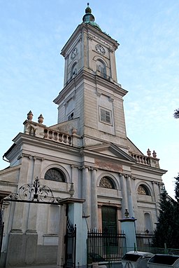
Calvinist Church
Kostol reformovanej kresťanskej cirkvi
Calvinist Church
Kostol reformovanej kresťanskej cirkvi
Original function:
church
Current function:
church
Church:
Calvinist
Settlement:
Address:
Jókaiho 31, 945 01 Komárno
Historical Hungarian county:
Komárom
Country:
Slovakia
GPS coordinates:
47.759928, 18.131243
Google map:
Useful links
History
The Classicist church was built in the 18th century. Its tower dating back to the 19th century is the highest point of the town with its 63 meters height. During the siege in 1849 in the Hungarian War of Independence it was used as a watch tower.
The church organ was created by Bohák János from Vienna.
In the rear of the building the frame of the Komárom Gate of the demolished fortress of Érsekújvár was set up. In the church courtyard there are gravestones from the 18th and19th century.
Check out other sights in Komárom as well!
Show on Google map
© OpenStreetMap contributors
{"item":"sight","set":{"sightId":31,"townId":3,"active":1,"name_LO":"Kostol reformovanej kres\u0165anskej cirkvi","address":"J\u00f3kaiho 31, 945 01 Kom\u00e1rno","mapdata":"1|435|267","gps_lat":"47.7599280000","gps_long":"18.1312430000","religion":2,"oldtype":"1","newtype":"1","homepage":"","openinghours":"","muemlekemlink":"","csemadoklink":"\r","picture":"\u003Ca title=\u0022Horakvlado (talk)Horakvlado \/ CC BY-SA (https:\/\/creativecommons.org\/licenses\/by-sa\/3.0)\u0022 href=\u0022https:\/\/commons.wikimedia.org\/wiki\/File:Kostol_reformovanej_kres%C5%A5anskej_cirkvi,_J%C3%B3kaiho_ul.31,_Kom%C3%A1rno,_okres_Kom%C3%A1rno_01.JPG\u0022\u003E\u003Cimg width=\u0022256\u0022 alt=\u0022Kostol reformovanej kres\u0165anskej cirkvi, J\u00f3kaiho ul.31, Kom\u00e1rno, okres Kom\u00e1rno 01\u0022 src=\u0022https:\/\/upload.wikimedia.org\/wikipedia\/commons\/thumb\/b\/b0\/Kostol_reformovanej_kres%C5%A5anskej_cirkvi%2C_J%C3%B3kaiho_ul.31%2C_Kom%C3%A1rno%2C_okres_Kom%C3%A1rno_01.JPG\/256px-Kostol_reformovanej_kres%C5%A5anskej_cirkvi%2C_J%C3%B3kaiho_ul.31%2C_Kom%C3%A1rno%2C_okres_Kom%C3%A1rno_01.JPG\u0022\u003E\u003C\/a\u003E","picture_ref":"\u003Ca href=\u0022https:\/\/commons.wikimedia.org\/wiki\/File:Kostol_reformovanej_kres%C5%A5anskej_cirkvi,_J%C3%B3kaiho_ul.31,_Kom%C3%A1rno,_okres_Kom%C3%A1rno_01.JPG\u0022 title=\u0022via Wikimedia Commons\u0022\u003EHorakvlado (talk)Horakvlado\u003C\/a\u003E \/ \u003Ca href=\u0022https:\/\/creativecommons.org\/licenses\/by-sa\/3.0\u0022\u003ECC BY-SA\u003C\/a\u003E","name":"Calvinist Church","note":"","history":"The Classicist church was built in the 18th century. Its tower dating back to the 19th century is the highest point of the town with its 63 meters height. During the siege in 1849 in the Hungarian War of Independence it was used as a watch tower.@The church organ was created by Boh\u00e1k J\u00e1nos from Vienna.@In the rear of the building the frame of the Kom\u00e1rom Gate of the demolished fortress of \u00c9rsek\u00fajv\u00e1r was set up. In the church courtyard there are gravestones from the 18th and19th century.","town":{"townId":3,"name_HU":"Kom\u00e1rom","name_LO":"Kom\u00e1rno","seolink":"komarom-komarno","oldcounty":3,"country":2}},"language":"en","region":"slovakia","regionid":2,"offer":[],"gallery":false,"album":false}

