Ipolyság
Historical Hungarian county:
Hont
GPS coordinates:
48.069794, 18.94808
Population
Population in 1910
| Total |
4206 |
| Hungarian |
95.17% |
| Slovak |
2.9% |
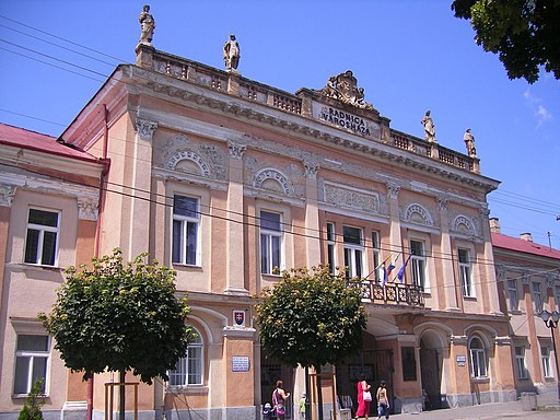
The former seat of Hont County could bear its title until 1920, when the almost entirely Hungarian town was attached from Hungary to the newly created Czechoslovakia. The Museum of Hont opened in the early 20th century was closed by the Czechoslovaks, but could be reopened in 1992 after having recovered most of its original collection. The former county hall, now town hall, hosts the gallery of the pictures of the Hungarian painter Simonyi Lajos. Despite the persecutions in the 20th century the town could preserve its Hungarian majority.
Check out other towns in Upper Hungary (Slovakia) as well!
895
Arrival of the Hungarians
Little more...
895
The alliance of the seven Hungarian tribes took possession of the then largely uninhabited Carpathian Basin. Until then, the sparse Slavic population of the north-western Carpathians had lived under Moravian rule for a few decades after the collapse of the Avar Khaganate in the early 9th century.
1000
Foundation of the Hungarian Kingdom
Little more...
1000
The Kingdom of Hungary was established with the coronation of King Stephen I. He converted the Hungarians to Christianity and created two archdioceses (Esztergom and Kalocsa) and ten dioceses. He divided Hungary into counties led by ispáns, who were appointed by the king.
1237
The settlement was mentioned for the first time as "Saag" in the diploma of King Béla IV of Hungary. The old Hungarian noun "ság" ment hill. The Norbertine monastery was established by Ban Márton of the Hont-Pázmány clan around that time.
1241-1242
Mongol Invasion
Little more...
1241-1242
The hordes of the Mongol Empire invaded Hungary and almost completely destroyed it. One third to one half of the population was destroyed. The Mongols also suffered heavy losses in the battle of Muhi and they could not hunt down the king. After their withdrawal, King Béla IV reorganized Hungary. He allowed the feudal lords to build stone castles because they were able to successfully resist the nomadic Mongols. The vast majority of stone castles were built after this. The king called in German, Vlach (Romanian) and Slavic settlers to replace the destroyed population.
1301
The extinction of the House of Árpád
Little more...
1301
The House of Árpád, the first Hungarian royal dynasty, died out with the death of King Andrew III. Hungary was ruled by oligarchs, the most powerful of whom was Csák Máté, whose main ally was the Aba family. King Charles I (1308-1342), supported by the Pope, eventually emerged as the most prominent of the contenders for the Hungarian throne. But it took decades to break the power of the oligarchs.
1405
Ipolyság gained the right to hold fairs.
1446
Lévai Cseh László occupied and looted the Norbertine monastery with his Czech mercenaries.
middle of the 15th century
The first fortifications of the town were built.
1451
The leader of the Czech Hussite marauders, Jiskra, occupied the town, but Hunyadi János took it back.
1526
Battle of Mohács and the splitting of Hungary into two parts
Little more...
1526
Sultan Suleiman I launched a war against Vienna, instigated by the French. Ferdinand I, Duke of Austria, was the brother-in-law of King Louis II of Hungary. The army of the Ottoman Empire defeated the much smaller Hungarian army at Mohács, and King Louis II died in the battle. A group of the barons elected Ferdinand I of the House of Habsburg to the throne, who promised to defend Hungary from the Turks. He was the younger brother of the most powerful European monarch Emperor Charles V. But the nobility chose the most powerful Hungarian baron, Szapolyai János, who was also crowned as King John I. The country was split in two and a decades-long struggle for power began.
1541
The Turkish occupation of the capital, Buda, and the division of Hungary into three parts
Little more...
1541
The Turks conquered Buda, the capital of Hungary, after the death of King John I. The central part of the country was under Turkish rule for 150 years. The western and northern parts (including present-day Slovakia) formed the Kingdom of Hungary ruled by the Habsburg emperors. The eastern parts (now mainly under Romanian rule) were ruled by the successors of King John I of Hungary. In 1571, John II (John Sigismund), the son of King John I of Hungary, renounced the title of King of Hungary in favor of King Maximilian of the House of Habsburg, and henceforth held the title of Prince. This formally created the Principality of Transylvania, which was the eastern half of Hungary not ruled by the Habsburgs and was also a vassal of the Ottoman Empire. John II died in 1571, after which the three nations of Transylvania (the Hungarian nobility, the Székelys and the Saxons) elected the prince.
1546
The monastery was transformed into a fortress at royal command.
1550
The Turks tried to occupy the town, but were repelled.
1552
The Turks occupied the town.
1595
The town was liberated from the Turks, and its fortifications were demolished.
1686
Recapture of Buda and the liberation of Hungary from the Turks
Little more...
1686
The army of the Holy League recaptured Buda from the Turks by siege. In 1687, the Imperial army invaded the Principality of Transylvania. The liberation was hindered by the French breaking their promise of peace in 1688 and attacking the Habsburg Empire. By 1699, when the Peace of Karlóca was signed, all of Hungary and Croatia had been liberated from the Ottoman Empire with the exception of Temesköz, the area bounded by the Maros, the Tisza and the Danube rivers. It was not until the Peace of Požarevac in 1718 that Temesköz was liberated from the Turks. However, the continuous war against the Turkish invaders and the Habsburg autocracy, which lasted for more than 150 years, wiped out large areas of the Hungarian population, which had previously made up 80% of the country's population, and was replaced by Vlachs (Romanians), Serbs and other Slavic settlers and Germans. The Habsburgs also favoured the settlement of these foreign peoples over the 'rebellious' Hungarians.
1703-1711
Hungarian War of Independence led by Prince Rákóczi Ferenc II
Little more...
1703-1711
After the expulsion of the Turks, the Habsburgs treated Hungary as a newly conquered province and did not respect its constitution. The serfs rose up against the Habsburg ruler because of the sufferings caused by the war and the heavy burdens, and they invited Rákóczi Ferenc II to lead them. Trusting in the help promised by King Louis XIV of France, he accepted. Rákóczi rallied the nobility to his side, and soon most of the country was under his control. The rebels were called the kurucs. In 1704, the French and the Bavarians were defeated at the Battle of Blenheim, depriving the Hungarians of their international allies. The Rusyn, Slovak and Vlach peasants and the Saxons of Szepes supported the fight for freedom, while the Serbs in the south and the Saxons in Transylvania served the Habsburgs. Due to lack of funds Rákóczi could not raise a strong regular army, and in 1710, Hungary was also hit by a severe plague. Rákóczi tried unsuccessfully to forge an alliance with Tsar Peter the Great of Russia. In his absence, without his knowledge, his commander-in-chief, Károlyi Sándor, accepted Emperor Joseph I's peace offer. The Peace of Szatmár formally restored the Hungarian constitution and religious freedom and granted amnesty, but did not ease the burden of serfdom. Rákóczi refused to accept the pardon and went into exile. He died in Rodosto, Turkey.
1704
Prince Rákóczi Ferenc II welcomed the delegation from Transylvania that brought him the news of his election as Prince of Transylvania.
1806
The seat of Hont County was moved from Kemence to Ipolyság. The town was the county seat until 1922.
1848-1849
Hungarian Revolution and War of Independence
Little more...
1848-1849
Following the news of the Paris Revolution on 22 February 1848, the Hungarian liberal opposition led by Kossuth Lajos demanded the abolition of serfdom, the abolition of the tax exemption of the nobility, a parliament elected by the people, and an independent and accountable national government. The revolution that broke out in Pest on 15 March expressed its demands in 12 points, which, in addition to the above mentioned, included the freedom of the press, equality before the law, the release of the political prisoners and the union with Transylvania. A Hungarian government was formed, Batthyány Lajos became prime minister, and on 11 April Emperor Ferdinand V ratified the reform laws. On August 31 the Emperor demanded the repeal of the laws threatening with military intervention. In September the Emperor unleashed the army of Jelacic, Ban of Croatia, on Hungary, but they were defeated by the Hungarians in the Battle of Pákozd on 29 September. An open war began for the independence of Hungary. The Habsburgs incited the nationalities against the Hungarians. The Rusyns, the Slovenes and most of the Slovaks and Germans supported the cause persistently, but the Vlachs (Romanians) and the Serbians turned against the Hungarians. The glorious Spring Campaign in 1849 led by General Görgei Artúr liberated almost all of Hungary. On 1 May 1849, Emperor Franz Joseph, effectively admitting defeat, asked for the help of Tsar Nicholas I of Russia, who sent an intervention army of 200,000 soldiers against Hungary. The resistance became hopeless against the overwhelming enemy forces and on 13 August Görgei Artúr surrendered to the Russians at Világos. Bloody reprisals followed, and on 6 October 1849, 12 generals and a colonel of the Hungarian Revolution, the martyrs of Arad, were executed in Arad. On the same day, Batthyány Lajos, the first Hungarian Prime Minister, was executed by firing squad in Pest. The Habsburgs introduced total authoritarianism in Hungary, but they also failed to fulfil their promises to the nationalities that had betrayed the Hungarians.
January 11, 1849
The troops of the Hungarian Guyon Richárd and the Imperial Anton Csorich fought a battle against each other next to the town during the Hungarian War of Independence.
1867
Austro-Hungarian Compromise
Little more...
1867
The Habsburg Empire was weakened by the defeats it suffered in the implementation of Italian and German unity. The Hungarians wanted to return to the reform laws of 1848, but they did not have the strength to do so. Emperor Franz Joseph and the Hungarian opposition, led by Deák Ferenc, finally agreed to restructure the Empire and abolish absolutism. Hungary was given autonomy in its internal affairs, with its own government and parliament, which was essential for the development of its economy and culture. However, foreign and military affairs remained in the hands of the Habsburgs and served their aspiration for becoming a great power. The majority wanted Hungary's independence, but they were excluded from political power.
1886
The railway reached the town. By 1909 the railway connection with Budapest was also established.
1913
State main grammar school was established, which took the name of Szondy György, the hero of Drégely Castle, in 1939 after the Hungarian town returned to Hungary thanks to the First Vienna Award.
1914-1918
World War I
Little more...
1914-1918
As part of the Austro-Hungarian Monarchy, Hungary took part in the war on the side of the Central Powers.
November 1918 - January 1919
The Czech, Romanian and Serbian occupation of Hungary
Little more...
November 1918 - January 1919
In Hungary, the freemasonic subversion brought the pro-Entente Károlyi Mihály to power. The new government, naively trusting the Entente powers, met all their demands and disbanded the Hungarian military, which rendered the country completely defenseless in the most dire need. Under French and Italian command, Czech, Romanian and Serbian troops invaded large parts of Hungary, where they immediately began the takeover. They fired Hungarian railway workers, officials and teachers, banned the use of the Hungarian language, abolished Hungarian education, and disposed of everything that reminded them of the country's Hungarian past. Hundreds of thousands of Hungarians were forced to leave their homeland, and the forcible assimilation of the remaining Hungarians was begun.
January 10, 1919
Czech legionnaires invaded the Hungarian town.
21 March - 1 August 1919
Communist takeover and the Northern Campaign
Little more...
21 March - 1 August 1919
After the Entente put vast areas with a Hungarian population under foreign administration, the pro-Entente government resigned and the traitorous Prime Minister Károlyi Mihály handed over power to the communists, who had little support anyway. They raised the Hungarian Red Army, which liberated large parts of northern Hungary from Czech occupation in the 'Northern Campaign'. The aim was to unite with the Russian Red Army, which ultimately failed because of the Russians' defeat. French Prime Minister Clemenceau promised the Jewish Kun Béla that he would recognise the Hungarian Soviet Republic and invite it to the peace conference if it would call back the army from northern Hungary. Calling back the army demoralized the soldiers, who fought for their homeland and not for communism. Clemenceau broke his promise and let the Romanian horde cross the Tisza River and capture Budapest.
May 29, 1919
The army of the Hungarian Soviet Republic liberated Ipolyság from the Czechoslovak invaders.
4 June 1920
Trianon Dictate
Little more...
4 June 1920
Hungary was forced to sign the Treaty of Trianon, although the country was not invited to the peace talks. Hungary lost two thirds of its territory that had belonged to it for more than 1000 years. One-third of the Hungarian population came under foreign rule. On the basis of the national principle, countries with a more mixed and less ethnically balanced composition than the former Hungary were created, such as Czechoslovakia and the Kingdom of Serbs, Croats and Slovenes (later Yugoslavia). For example, while 48% of the population of the territory ceded to Czechoslovakia was Slovak and 30% Hungarian, 54% of the population of the former Hungary was Hungarian and 10.6% Slovak. And in the territory that is now part of Serbia, the Hungarians outnumbered the Serbs. The part of the territory allocated to Romania from Hungary was larger than the remaining territory of Hungary, despite the fact that there were 10 million Hungarians and less than 3 million Romanians in the former Hungary. While Hungary used to have the most liberal nationality policy in Europe, the successor states had no respect at all for the national and cultural rights of the indigenous Hungarians and engaged in forced assimilation. The Trianon Dictate destroyed the organic economic unity of the region. Before the First World War, Hungary had a dynamic economy, more advanced than Spain's. After 1920, the successor states formed the so-called "Little Entente", putting Hungary under an economic blockade and sabotaging it on the international stage.
2 November 1938
First Vienna Award
Little more...
2 November 1938
Under the First Vienna Award, Hungary regained 11,927 km2 of territory from Czechoslovakia. Its population was 869 thousand people, 86.5% of whom were Hungarian. France and Great Britain did not take part in the decision taken by Germany and Italy, citing disinterest, but acknowledged its validity.
November 2, 1938
Ipolyság returned to Hungary according to the First Vienna Award.
Autumn 1944 - Spring 1945
Soviet occupation
Little more...
Autumn 1944 - Spring 1945
The Soviet Red Army occupied Hungary and Slovakia, which resulted in the recreation of Czechoslovakia.
5 April 1945
Beneš decrees and the persecution of Hungarians
Little more...
5 April 1945
In Hungarian-majority Kassa, the president of occupying Czechoslovakia, Edvard Beneš, promulgated his government program, the so-called Beneš decrees. As part of this, the Hungarian population was deprived of their rights. Their complete expulsion was planned, with the support of the Soviet Union, and only the veto of the USA prevented it. Under the 'Reslavakization' programme, only those Hungarians who recognised themselves as Slovaks were allowed to regain their rights, thus renouncing all linguistic and cultural rights. In the violent expulsions that followed, nearly 200,000 Hungarians were deprived of their property and expelled from their homeland on the basis of their nationality.
1947
Paris Dictate
Little more...
1947
The Paris Dictate, in accordance with Soviet interests, did not recognise the just territorial revisions made by the two Vienna decisions and handed the reclaimed Hungarian-majority territories back to Czechoslovakia, Romania and Yugoslavia, where the Hungarians were subjected to severe atrocities, expulsions and deprivation of rights. It also seceded three more villages south of Pozsony from Hungary to Czechoslovakia.
1 January 1993
Dissolution of Czechoslovakia
Little more...
1 January 1993
Czechoslovakia disintegrated due to ethnic differences between Czechs and Slovaks, shortly after the withdrawal of Soviet tanks. Slovakia was formed entirely from territory carved out of historic Hungary, and Slovak national identity is still largely based on falsified history and artificial hatred of Hungarians. Despite deportations, expulsions, forced assimilation and strong economic pressure, there are still nearly half a million Hungarians living in the country.
Sights
All
Churches, religious buildings
Public buildings
Cultural facilities
Commerce, industry, hospitality
Memorials
Museums and Galleries
Churches, religious buildings
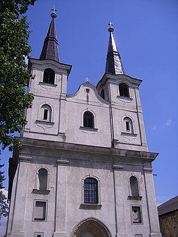
Church of the Assumption of the Blessed Virgin Mary
Rímsko-katolícky kostol
Show on map
Visit
Church of the Assumption of the Blessed Virgin Mary
History
The first church was built by the Norbertines in the first half of the 13th century and was destroyed by the Turks in 1552.
The church was rebuilt in 1734 by the Jesuits in Renaissance-Baroque style. Its two side altars (Sacred Heart of Jesus and Our Lady of Lourdes) are from the 20th century. The church has a statue of Virgin Mary from the 16th century.
Calvinist Church
Kostol Reformovanej cirkvi
Show on map
Visit
Calvinist Church
History
The Calvinist church was built between 2008 and 2014.
Lutheran Church
Evanjelický kostol
Show on map
Visit
Lutheran Church
History
The church was built in 1906.
Calvary
Show on map
Visit
Calvary
History
The Calvary was built in 1907 on the eastern edge of the town.
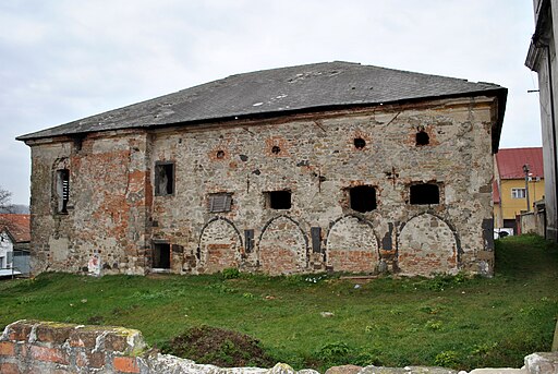
former Norbertine Monastery
Originally:
monastery / nunnery / canon's house / provost residence
Show on map
Visit
former Norbertine Monastery
History
Ban Márton of the Hont-Pázmány clan built a monastery for the Norbertine order of canons around 1237, and he left his properties on the monastery. The monastery was devastated by Mongols between 1241 and 1242 and was looted by the Czech mercenaries of Lévai Cseh László in 1446. In 1451 the Czech Hussite marauders of Jiskra occupied it, and they were driven out by Hunyadi János. In the 16th century the monastery was fortified and turned into a castle against the Turks. In 1550 the castle repelled a Turkish attack under the command of Jakusich Ferenc. But in 1552 its defenders set it on fire and left after having heard of the fall of Drégely Castle. It was in the hands of the Turks between 1552 and 1595 and again between 1626 and 1686. After having been liberated from the Turks, Emperor Leopold I gave it to the Jesuits, who built farm buildings and a granary on the ruins of the former monastery. Only the portal of the church and the Gothic arches of the cloisters are left of the former monastery.
Neolog Synagogue
Synagóga
Show on map
Visit
Neolog Synagogue
History
The Jews migrated into the town after 1840. The Status Quo Ante synagogue was built in 1852. It is now a cultural center.
Public buildings
former County Hall, Town Hall and Simony Lajos Gallery
Mestský úrad Šahy
Show on map
Visit
former County Hall, Town Hall and Simony Lajos Gallery
History
The building was constructed between 1827 and 1857 in Zopf-Classicist style. It was the seat of Hont County within Hungary. The Museum of Hont was opened in the building in 1902. It is now the town hall and it also hosts the gallery of the pictures of Simonyi Lajos.
former Financial Palace
Originally:
public administration
Note:
Fegyverneki Ferenc Grammar School
Show on map
Visit
former Financial Palace
History
It was built at the beginning of the 20th century. It is now a grammar school.
Cultural facilities
Roman Catholic Elementary School
Odborné Učilište - Internátne
Note:
Boarding school of vocational training.
Show on map
Visit
Roman Catholic Elementary School
History
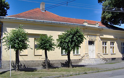
Museum of Hont
Hontianske múzeum
Show on map
Visit
Commerce, industry, hospitality
former Central Hotel
Originally:
hotel / tavern / guesthouse
Show on map
Visit
former Central Hotel
History
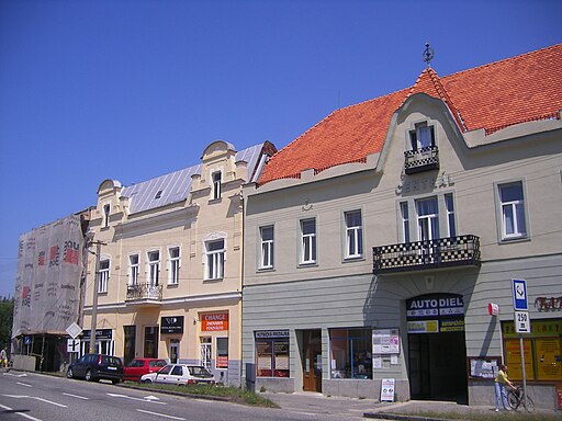
The hotel was built in 1906. The world "Centrál" is written on its facade.
In 1898 an exhibition was organized at the county hall by Pongrácz Elemér and Matunák Mihály. lt got nationwide attention in Hungary. Afterwards they decided to establish a museum. It was opened in 1902 and was called Museum of Hont. Pongrácz Elemér became its first director. After the Czechoslovak invasion, the museum was closed in 1924 and its collection was taken over by the Museum of Mining in Selmecbánya. The museum could be reopened in 1992 and it managed to recover most of its original collection.
The museum is now located in the renovated Mühlstein House on Rotarides Street. It has a historical, archeological, ethnographical and artistic collection. The gallery of the paintings of Simonyi Lajos and the temporary exhibitions are in the former county hall that is now the town hall.
former Lengyel Hotel
Originally:
hotel / tavern / guesthouse
Show on map
Visit
former Lengyel Hotel
History
The hotel was built at the end of the 19th century. The famous Hungarian writer Móricz Zsigmond also stayed in the hotel in 1932.
former Savings Bank
Show on map
Visit
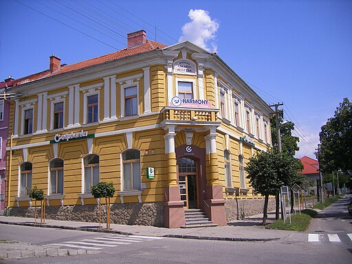
former Savings Bank
History
Memorials
Statue of Saint Stephen of Hungary
Originally:
statue / memorial / relief
Currently:
statue / memorial / relief
Show on map
Visit
Statue of Saint Stephen of Hungary
History
The statue was unveiled in 2013 on the square before the Catholic church. It is the artwork of Dr. Kernács Károly.
Bust of Sajó Sándor
Originally:
statue / memorial / relief
Currently:
statue / memorial / relief
Show on map
Visit
Bust of Sajó Sándor
History
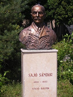
Sajó Sándor (1868-1933) was a Hungarian poet and teacher born in lpolyság.
Statue of St. John of Nepomuk
Originally:
statue / memorial / relief
Currently:
statue / memorial / relief
Show on map
Visit
Statue of St. John of Nepomuk
History
The statue of St. John of Nepomuk was placed on the stone railing of the bridge over the Ipoly River. At the end of World War II the retreating German troops exploded the bridge and the statue was destroyed. The current statue was erected in 2010. It is the artwork of Mag Gyula.
Immaculata Statue
Originally:
statue / memorial / relief
Currently:
statue / memorial / relief
Show on map
Visit
Immaculata Statue
History
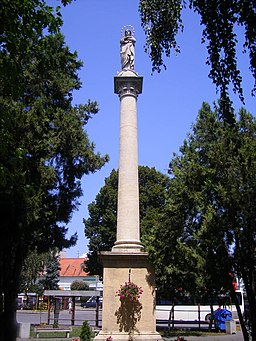
The statue was erected in 1859 on the main square.
Statue of St. Florian
Originally:
statue / memorial / relief
Currently:
statue / memorial / relief
Show on map
Visit
Statue of St. Florian
History
The statue was erected in the 18th century.
Museums and Galleries
Neolog Synagogue
Synagóga
Show on map
Visit
Neolog Synagogue
History
The Jews migrated into the town after 1840. The Status Quo Ante synagogue was built in 1852. It is now a cultural center.
former County Hall, Town Hall and Simony Lajos Gallery
Mestský úrad Šahy
Show on map
Visit
former County Hall, Town Hall and Simony Lajos Gallery
History
The building was constructed between 1827 and 1857 in Zopf-Classicist style. It was the seat of Hont County within Hungary. The Museum of Hont was opened in the building in 1902. It is now the town hall and it also hosts the gallery of the pictures of Simonyi Lajos.
Museum of Hont
Hontianske múzeum
Show on map
Visit
{"item":"town","set":{"mapcenter":{"lat":"48.0697940000","long":"18.9480800000"},"townlink":"ipolysag-sahy","town":{"townId":37,"active":1,"name_HU":"Ipolys\u00e1g","name_LO":"\u0160ahy","name_GE":"Eipelschlag","name_LT":"","seolink":"ipolysag-sahy","listorder":25,"oldcounty":5,"country":2,"division":2,"altitude":"135","gps_lat":"48.0697940000","gps_long":"18.9480800000","population":7,"hungarian_2011":57.84,"population_1910":4206,"hungarian_1910":95.17,"german_1910":0,"slovak_1910":2.9,"romanian_1910":0,"rusin_1910":0,"serbian_1910":0,"croatian_1910":0,"slovenian_1910":0,"coatofarms":"","coatofarms_ref":"","picture":"\u003Ca title=\u0022Szeder L\u00e1szl\u00f3 \/ CC BY-SA (https:\/\/creativecommons.org\/licenses\/by-sa\/4.0)\u0022 href=\u0022https:\/\/commons.wikimedia.org\/wiki\/File:Ipolys%C3%A1g025.JPG\u0022\u003E\u003Cimg width=\u0022512\u0022 alt=\u0022Ipolys\u00e1g025\u0022 src=\u0022https:\/\/upload.wikimedia.org\/wikipedia\/commons\/thumb\/d\/d2\/Ipolys%C3%A1g025.JPG\/512px-Ipolys%C3%A1g025.JPG\u0022\u003E\u003C\/a\u003E","picture_ref":"\u003Ca href=\u0022https:\/\/commons.wikimedia.org\/wiki\/File:Ipolys%C3%A1g025.JPG\u0022 title=\u0022via Wikimedia Commons\u0022\u003ESzeder L\u00e1szl\u00f3\u003C\/a\u003E \/ \u003Ca href=\u0022https:\/\/creativecommons.org\/licenses\/by-sa\/4.0\u0022\u003ECC BY-SA\u003C\/a\u003E","georegion":"Ipoly Valley","river":"Ipoly","description":"The former seat of Hont County could bear its title until 1920, when the almost entirely Hungarian town was attached from Hungary to the newly created Czechoslovakia. The Museum of Hont opened in the early 20th century was closed by the Czechoslovaks, but could be reopened in 1992 after having recovered most of its original collection. The former county hall, now town hall, hosts the gallery of the pictures of the Hungarian painter Simonyi Lajos. Despite the persecutions in the 20th century the town could preserve its Hungarian majority.","nameorigin":"","history":"#1|@#3|@1237|The settlement was mentioned for the first time as \u0022Saag\u0022 in the diploma of King B\u00e9la IV of Hungary. The old Hungarian noun \u0022s\u00e1g\u0022 ment hill. The Norbertine monastery was established by Ban M\u00e1rton of the Hont-P\u00e1zm\u00e1ny clan around that time.@#5|@#6|@1405|Ipolys\u00e1g gained the right to hold fairs.@1446|L\u00e9vai Cseh L\u00e1szl\u00f3 occupied and looted the Norbertine monastery with his Czech mercenaries.@middle of the 15th century|The first fortifications of the town were built.@1451|The leader of the Czech Hussite marauders, Jiskra, occupied the town, but Hunyadi J\u00e1nos took it back.@#8|@#11|@1546|The monastery was transformed into a fortress at royal command.@1550|The Turks tried to occupy the town, but were repelled.@1552|The Turks occupied the town.@1595|The town was liberated from the Turks, and its fortifications were demolished.@#25|@#27|@1704|Prince R\u00e1k\u00f3czi Ferenc II welcomed the delegation from Transylvania that brought him the news of his election as Prince of Transylvania.@1806|The seat of Hont County was moved from Kemence to Ipolys\u00e1g. The town was the county seat until 1922.@#28|@January 11, 1849|The troops of the Hungarian Guyon Rich\u00e1rd and the Imperial Anton Csorich fought a battle against each other next to the town during the Hungarian War of Independence.@#30|@1886|The railway reached the town. By 1909 the railway connection with Budapest was also established.@1913|State main grammar school was established, which took the name of Szondy Gy\u00f6rgy, the hero of Dr\u00e9gely Castle, in 1939 after the Hungarian town returned to Hungary thanks to the First Vienna Award.@#31|@#32|@January 10, 1919|Czech legionnaires invaded the Hungarian town.@#34|@May 29, 1919|The army of the Hungarian Soviet Republic liberated Ipolys\u00e1g from the Czechoslovak invaders.@#36|@#37|@November 2, 1938|Ipolys\u00e1g returned to Hungary according to the First Vienna Award.@#41|@#42|@#43|@#44|&"},"sights":[{"sightId":727,"townId":37,"active":1,"name_LO":"R\u00edmsko-katol\u00edcky kostol","address":"\u0160kolsk\u00e1 ulica 8","mapdata":"1|750|809","gps_lat":"48.0695950000","gps_long":"18.9514090000","religion":1,"oldtype":"1","newtype":"1","homepage":"","openinghours":"","muemlekemlink":"","csemadoklink":"http:\/\/emlekhelyek.csemadok.sk\/emlekhelyek\/nagyboldogasszony-plebaniatemplom\/\r","picture":"\u003Ca title=\u0022Szeder L\u00e1szl\u00f3 \/ CC BY-SA (https:\/\/creativecommons.org\/licenses\/by-sa\/4.0)\u0022 href=\u0022https:\/\/commons.wikimedia.org\/wiki\/File:Ipolys%C3%A1g039.JPG\u0022\u003E\u003Cimg width=\u0022256\u0022 alt=\u0022Ipolys\u00e1g039\u0022 src=\u0022https:\/\/upload.wikimedia.org\/wikipedia\/commons\/thumb\/4\/4a\/Ipolys%C3%A1g039.JPG\/256px-Ipolys%C3%A1g039.JPG\u0022\u003E\u003C\/a\u003E","picture_ref":"\u003Ca href=\u0022https:\/\/commons.wikimedia.org\/wiki\/File:Ipolys%C3%A1g039.JPG\u0022 title=\u0022via Wikimedia Commons\u0022\u003ESzeder L\u00e1szl\u00f3\u003C\/a\u003E \/ \u003Ca href=\u0022https:\/\/creativecommons.org\/licenses\/by-sa\/4.0\u0022\u003ECC BY-SA\u003C\/a\u003E","name":"Church of the Assumption of the Blessed Virgin Mary","seolink":"church-of-the-assumption-of-the-blessed-virgin-mary","note":"","history":"The first church was built by the Norbertines in the first half of the 13th century and was destroyed by the Turks in 1552.@The church was rebuilt in 1734 by the Jesuits in Renaissance-Baroque style. Its two side altars (Sacred Heart of Jesus and Our Lady of Lourdes) are from the 20th century. The church has a statue of Virgin Mary from the 16th century."},{"sightId":728,"townId":37,"active":1,"name_LO":"","address":"Kapitulsk\u00e1\u00a0","mapdata":"1|743|830","gps_lat":"48.0693460000","gps_long":"18.9514280000","religion":1,"oldtype":"5","newtype":"120","homepage":"","openinghours":"","muemlekemlink":"","csemadoklink":"http:\/\/emlekhelyek.csemadok.sk\/emlekhelyek\/ipolysagi-monostor\/\r","picture":"\u003Ca title=\u0022Pe-Jo \/ CC BY-SA (https:\/\/creativecommons.org\/licenses\/by-sa\/3.0)\u0022 href=\u0022https:\/\/commons.wikimedia.org\/wiki\/File:Ipolys%C3%A1g-premontrei_kolostor.JPG\u0022\u003E\u003Cimg width=\u0022512\u0022 alt=\u0022Ipolys\u00e1g-premontrei kolostor\u0022 src=\u0022https:\/\/upload.wikimedia.org\/wikipedia\/commons\/thumb\/a\/a8\/Ipolys%C3%A1g-premontrei_kolostor.JPG\/512px-Ipolys%C3%A1g-premontrei_kolostor.JPG\u0022\u003E\u003C\/a\u003E","picture_ref":"\u003Ca href=\u0022https:\/\/commons.wikimedia.org\/wiki\/File:Ipolys%C3%A1g-premontrei_kolostor.JPG\u0022 title=\u0022via Wikimedia Commons\u0022\u003EPe-Jo\u003C\/a\u003E \/ \u003Ca href=\u0022https:\/\/creativecommons.org\/licenses\/by-sa\/3.0\u0022\u003ECC BY-SA\u003C\/a\u003E","name":"former Norbertine Monastery ","seolink":"former-norbertine-monastery","note":"","history":"Ban M\u00e1rton of the Hont-P\u00e1zm\u00e1ny clan built a monastery for the Norbertine order of canons around 1237, and he left his properties on the monastery. The monastery was devastated by Mongols between 1241 and 1242 and was looted by the Czech mercenaries of L\u00e9vai Cseh L\u00e1szl\u00f3 in 1446. In 1451 the Czech Hussite marauders of Jiskra occupied it, and they were driven out by Hunyadi J\u00e1nos. In the 16th century the monastery was fortified and turned into a castle against the Turks. In 1550 the castle repelled a Turkish attack under the command of Jakusich Ferenc. But in 1552 its defenders set it on fire and left after having heard of the fall of Dr\u00e9gely Castle. It was in the hands of the Turks between 1552 and 1595 and again between 1626 and 1686. After having been liberated from the Turks, Emperor Leopold I gave it to the Jesuits, who built farm buildings and a granary on the ruins of the former monastery. Only the portal of the church and the Gothic arches of the cloisters are left of the former monastery."},{"sightId":729,"townId":37,"active":1,"name_LO":"Mestsk\u00fd \u00farad \u0160ahy","address":"Hlavn\u00e9 n\u00e1mestie 34\/34, 936 01 \u0160ahy","mapdata":"1|497|806","gps_lat":"48.0696200000","gps_long":"18.9473160000","religion":0,"oldtype":"11","newtype":"99","homepage":"http:\/\/hu.sahy.sk\/","openinghours":"","muemlekemlink":"","csemadoklink":"\r","picture":"\u003Ca title=\u0022Szeder L\u00e1szl\u00f3 \/ CC BY-SA (https:\/\/creativecommons.org\/licenses\/by-sa\/4.0)\u0022 href=\u0022https:\/\/commons.wikimedia.org\/wiki\/File:Ipolys%C3%A1g015.JPG\u0022\u003E\u003Cimg width=\u0022512\u0022 alt=\u0022Ipolys\u00e1g015\u0022 src=\u0022https:\/\/upload.wikimedia.org\/wikipedia\/commons\/thumb\/d\/d4\/Ipolys%C3%A1g015.JPG\/512px-Ipolys%C3%A1g015.JPG\u0022\u003E\u003C\/a\u003E","picture_ref":"\u003Ca href=\u0022https:\/\/commons.wikimedia.org\/wiki\/File:Ipolys%C3%A1g015.JPG\u0022 title=\u0022via Wikimedia Commons\u0022\u003ESzeder L\u00e1szl\u00f3\u003C\/a\u003E \/ \u003Ca href=\u0022https:\/\/creativecommons.org\/licenses\/by-sa\/4.0\u0022\u003ECC BY-SA\u003C\/a\u003E","name":"former County Hall, Town Hall and Simony Lajos Gallery ","seolink":"former-county-hall-town-hall-and-simony-lajos-gallery","note":"","history":"The building was constructed between 1827 and 1857 in Zopf-Classicist style. It was the seat of Hont County within Hungary. The Museum of Hont was opened in the building in 1902. It is now the town hall and it also hosts the gallery of the pictures of Simonyi Lajos."},{"sightId":730,"townId":37,"active":1,"name_LO":"Evanjelick\u00fd kostol","address":"F. R\u00e1k\u00f3cziho II 597\/18, 936 01 \u0160ahy","mapdata":"1|828|756","gps_lat":"48.0702750000","gps_long":"18.9522360000","religion":3,"oldtype":"1","newtype":"1","homepage":"","openinghours":"","muemlekemlink":"","csemadoklink":"\r","picture":"","picture_ref":"","name":"Lutheran Church ","seolink":"lutheran-church","note":"","history":"The church was built in 1906."},{"sightId":731,"townId":37,"active":1,"name_LO":"","address":"Podz\u00e1mock\u00e1 553\/10, 936 01 \u0160ahy","mapdata":"1|994|628","gps_lat":"48.0716270000","gps_long":"18.9557020000","religion":1,"oldtype":"3","newtype":"1","homepage":"","openinghours":"","muemlekemlink":"https:\/\/www.muemlekem.hu\/hatareset\/Kalvaria-Ipolysag-3760","csemadoklink":"\r","picture":"\u003Ca title=\u0022Pe-Jo \/ Public domain\u0022 href=\u0022https:\/\/commons.wikimedia.org\/wiki\/File:Kalvaria-Ipolysag-2007-7.JPG\u0022\u003E\u003Cimg width=\u0022512\u0022 alt=\u0022Kalvaria-Ipolysag-2007-7\u0022 src=\u0022https:\/\/upload.wikimedia.org\/wikipedia\/commons\/thumb\/7\/71\/Kalvaria-Ipolysag-2007-7.JPG\/512px-Kalvaria-Ipolysag-2007-7.JPG\u0022\u003E\u003C\/a\u003E","picture_ref":"\u003Ca href=\u0022https:\/\/commons.wikimedia.org\/wiki\/File:Kalvaria-Ipolysag-2007-7.JPG\u0022 title=\u0022via Wikimedia Commons\u0022\u003EPe-Jo\u003C\/a\u003E \/ Public domain","name":"Calvary","seolink":"calvary","note":"","history":"The Calvary was built in 1907 on the eastern edge of the town."},{"sightId":732,"townId":37,"active":1,"name_LO":"Synag\u00f3ga","address":"N\u00e1mestie B\u00e9lu Bart\u00f3ka 12, 936 01 \u0160ahy","mapdata":"1|574|642","gps_lat":"48.0716450000","gps_long":"18.9484670000","religion":6,"oldtype":"8","newtype":"106","homepage":"","openinghours":"","muemlekemlink":"https:\/\/www.muemlekem.hu\/hatareset\/Status-quo-ante-zsinagoga-Ipolysag-1002","csemadoklink":"\r","picture":"","picture_ref":"","name":"Neolog Synagogue ","seolink":"neolog-synagogue","note":"","history":"The Jews migrated into the town after 1840. The Status Quo Ante synagogue was built in 1852. It is now a cultural center."},{"sightId":733,"townId":37,"active":1,"name_LO":"","address":"Hlavn\u00e9 n\u00e1mestie ","mapdata":"1|599|784","gps_lat":"48.0697580000","gps_long":"18.9490170000","religion":0,"oldtype":"80","newtype":"53","homepage":"","openinghours":"","muemlekemlink":"","csemadoklink":"\r","picture":"","picture_ref":"","name":"former Lengyel Hotel ","seolink":"former-lengyel-hotel","note":"","history":"The hotel was built at the end of the 19th century. The famous Hungarian writer M\u00f3ricz Zsigmond also stayed in the hotel in 1932."},{"sightId":734,"townId":37,"active":1,"name_LO":"","address":"SNP 4","mapdata":"1|507|562","gps_lat":"48.0723850000","gps_long":"18.9474440000","religion":0,"oldtype":"15","newtype":"74","homepage":"https:\/\/cogff.edupage.org\/","openinghours":"","muemlekemlink":"","csemadoklink":"\r","picture":"","picture_ref":"","name":"former Financial Palace ","seolink":"former-financial-palace","note":"Fegyverneki Ferenc Grammar School","history":"It was built at the beginning of the 20th century. It is now a grammar school."},{"sightId":735,"townId":37,"active":1,"name_LO":"Odborn\u00e9 U\u010dili\u0161te - Intern\u00e1tne","address":"Kapitulsk\u00e1 653, 936 01 \u0160ahy","mapdata":"1|695|797","gps_lat":"48.0697460000","gps_long":"18.9506510000","religion":1,"oldtype":"74","newtype":"74","homepage":"","openinghours":"","muemlekemlink":"","csemadoklink":"\r","picture":"\u003Ca title=\u0022Szeder L\u00e1szl\u00f3 \/ CC BY-SA (https:\/\/creativecommons.org\/licenses\/by-sa\/4.0)\u0022 href=\u0022https:\/\/commons.wikimedia.org\/wiki\/File:Ipolys%C3%A1g038.JPG\u0022\u003E\u003Cimg width=\u0022512\u0022 alt=\u0022Ipolys\u00e1g038\u0022 src=\u0022https:\/\/upload.wikimedia.org\/wikipedia\/commons\/thumb\/1\/1c\/Ipolys%C3%A1g038.JPG\/512px-Ipolys%C3%A1g038.JPG\u0022\u003E\u003C\/a\u003E","picture_ref":"\u003Ca href=\u0022https:\/\/commons.wikimedia.org\/wiki\/File:Ipolys%C3%A1g038.JPG\u0022 title=\u0022via Wikimedia Commons\u0022\u003ESzeder L\u00e1szl\u00f3\u003C\/a\u003E \/ \u003Ca href=\u0022https:\/\/creativecommons.org\/licenses\/by-sa\/4.0\u0022\u003ECC BY-SA\u003C\/a\u003E","name":"Roman Catholic Elementary School","seolink":"roman-catholic-elementary-school","note":"Boarding school of vocational training.","history":"It was built in 1872."},{"sightId":736,"townId":37,"active":1,"name_LO":"","address":"Hontianska cesta","mapdata":"1|615|863","gps_lat":"48.0688960000","gps_long":"18.9493740000","religion":0,"oldtype":"80","newtype":"53","homepage":"","openinghours":"","muemlekemlink":"","csemadoklink":"\r","picture":"\u003Ca title=\u0022Szeder L\u00e1szl\u00f3 \/ CC BY-SA (https:\/\/creativecommons.org\/licenses\/by-sa\/4.0)\u0022 href=\u0022https:\/\/commons.wikimedia.org\/wiki\/File:Ipolys%C3%A1g024.JPG\u0022\u003E\u003Cimg width=\u0022512\u0022 alt=\u0022Ipolys\u00e1g024\u0022 src=\u0022https:\/\/upload.wikimedia.org\/wikipedia\/commons\/thumb\/2\/25\/Ipolys%C3%A1g024.JPG\/512px-Ipolys%C3%A1g024.JPG\u0022\u003E\u003C\/a\u003E","picture_ref":"\u003Ca href=\u0022https:\/\/commons.wikimedia.org\/wiki\/File:Ipolys%C3%A1g024.JPG\u0022 title=\u0022via Wikimedia Commons\u0022\u003ESzeder L\u00e1szl\u00f3\u003C\/a\u003E \/ \u003Ca href=\u0022https:\/\/creativecommons.org\/licenses\/by-sa\/4.0\u0022\u003ECC BY-SA\u003C\/a\u003E","name":"former Central Hotel ","seolink":"former-central-hotel","note":"","history":"The hotel was built in 1906. The world \u0022Centr\u00e1l\u0022 is written on its facade.@In 1898 an exhibition was organized at the county hall by Pongr\u00e1cz Elem\u00e9r and Matun\u00e1k Mih\u00e1ly. lt got nationwide attention in Hungary. Afterwards they decided to establish a museum. It was opened in 1902 and was called Museum of Hont. Pongr\u00e1cz Elem\u00e9r became its first director. After the Czechoslovak invasion, the museum was closed in 1924 and its collection was taken over by the Museum of Mining in Selmecb\u00e1nya. The museum could be reopened in 1992 and it managed to recover most of its original collection.@The museum is now located in the renovated M\u00fchlstein House on Rotarides Street. It has a historical, archeological, ethnographical and artistic collection. The gallery of the paintings of Simonyi Lajos and the temporary exhibitions are in the former county hall that is now the town hall."},{"sightId":737,"townId":37,"active":1,"name_LO":"Hontianske m\u00fazeum\u00a0","address":"J. Rotaridesa 13, 936 01 \u0160ahy","mapdata":"1|581|587","gps_lat":"48.0720920000","gps_long":"18.9487800000","religion":0,"oldtype":"120","newtype":"98","homepage":"","openinghours":"","muemlekemlink":"","csemadoklink":"\r","picture":"\u003Ca title=\u0022Pe-Jo \/ CC BY (https:\/\/creativecommons.org\/licenses\/by\/3.0)\u0022 href=\u0022https:\/\/commons.wikimedia.org\/wiki\/File:Honti_m%C3%BAzeum_-Ipolys%C3%A1g2.JPG\u0022\u003E\u003Cimg width=\u0022512\u0022 alt=\u0022Honti m\u00fazeum -Ipolys\u00e1g2\u0022 src=\u0022https:\/\/upload.wikimedia.org\/wikipedia\/commons\/thumb\/3\/3b\/Honti_m%C3%BAzeum_-Ipolys%C3%A1g2.JPG\/512px-Honti_m%C3%BAzeum_-Ipolys%C3%A1g2.JPG\u0022\u003E\u003C\/a\u003E","picture_ref":"\u003Ca href=\u0022https:\/\/commons.wikimedia.org\/wiki\/File:Honti_m%C3%BAzeum_-Ipolys%C3%A1g2.JPG\u0022 title=\u0022via Wikimedia Commons\u0022\u003EPe-Jo\u003C\/a\u003E \/ \u003Ca href=\u0022https:\/\/creativecommons.org\/licenses\/by\/3.0\u0022\u003ECC BY\u003C\/a\u003E","name":"Museum of Hont ","seolink":"museum-of-hont","note":"","history":""},{"sightId":738,"townId":37,"active":1,"name_LO":"","address":"Hlavn\u00e9 n\u00e1mestie ","mapdata":"1|548|760","gps_lat":"48.0700990000","gps_long":"18.9480720000","religion":1,"oldtype":"38","newtype":"38","homepage":"","openinghours":"","muemlekemlink":"","csemadoklink":"\r","picture":"\u003Ca title=\u0022Szeder L\u00e1szl\u00f3 \/ CC BY-SA (https:\/\/creativecommons.org\/licenses\/by-sa\/4.0)\u0022 href=\u0022https:\/\/commons.wikimedia.org\/wiki\/File:Ipolys%C3%A1g030.JPG\u0022\u003E\u003Cimg width=\u0022256\u0022 alt=\u0022Ipolys\u00e1g030\u0022 src=\u0022https:\/\/upload.wikimedia.org\/wikipedia\/commons\/thumb\/4\/43\/Ipolys%C3%A1g030.JPG\/256px-Ipolys%C3%A1g030.JPG\u0022\u003E\u003C\/a\u003E","picture_ref":"\u003Ca href=\u0022https:\/\/commons.wikimedia.org\/wiki\/File:Ipolys%C3%A1g030.JPG\u0022 title=\u0022via Wikimedia Commons\u0022\u003ESzeder L\u00e1szl\u00f3\u003C\/a\u003E \/ \u003Ca href=\u0022https:\/\/creativecommons.org\/licenses\/by-sa\/4.0\u0022\u003ECC BY-SA\u003C\/a\u003E","name":"Immaculata Statue ","seolink":"immaculata-statue","note":"","history":"The statue was erected in 1859 on the main square."},{"sightId":739,"townId":37,"active":1,"name_LO":"","address":"Janka Kr\u00e1l'a","mapdata":"1|345|817","gps_lat":"48.0694470000","gps_long":"18.9445900000","religion":1,"oldtype":"38","newtype":"38","homepage":"","openinghours":"","muemlekemlink":"","csemadoklink":"\r","picture":"\u003Ca title=\u0022Szeder L\u00e1szl\u00f3 \/ CC BY-SA (https:\/\/creativecommons.org\/licenses\/by-sa\/4.0)\u0022 href=\u0022https:\/\/commons.wikimedia.org\/wiki\/File:Ipolys%C3%A1g014.JPG\u0022\u003E\u003Cimg width=\u0022256\u0022 alt=\u0022Ipolys\u00e1g014\u0022 src=\u0022https:\/\/upload.wikimedia.org\/wikipedia\/commons\/thumb\/4\/4e\/Ipolys%C3%A1g014.JPG\/256px-Ipolys%C3%A1g014.JPG\u0022\u003E\u003C\/a\u003E","picture_ref":"\u003Ca href=\u0022https:\/\/commons.wikimedia.org\/wiki\/File:Ipolys%C3%A1g014.JPG\u0022 title=\u0022via Wikimedia Commons\u0022\u003ESzeder L\u00e1szl\u00f3\u003C\/a\u003E \/ \u003Ca href=\u0022https:\/\/creativecommons.org\/licenses\/by-sa\/4.0\u0022\u003ECC BY-SA\u003C\/a\u003E","name":"Statue of St. Florian ","seolink":"statue-of-st-florian","note":"","history":"The statue was erected in the 18th century."},{"sightId":740,"townId":37,"active":1,"name_LO":"Kostol Reformovanej cirkvi","address":"N\u00e1mestie Milana Rastislava \u0160tef\u00e1nika","mapdata":"1|696|166","gps_lat":"48.0770020000","gps_long":"18.9506740000","religion":2,"oldtype":"1","newtype":"1","homepage":"http:\/\/www.ipolysag.reformatus.sk\/","openinghours":"","muemlekemlink":"","csemadoklink":"\r","picture":"","picture_ref":"","name":"Calvinist Church","seolink":"calvinist-church","note":"","history":"The Calvinist church was built between 2008 and 2014."},{"sightId":741,"townId":37,"active":1,"name_LO":"","address":"Ipoly h\u00edd h\u00eddf\u0151j\u00e9n\u00e9l","mapdata":"1|623|913","gps_lat":"48.0683500000","gps_long":"18.9494930000","religion":1,"oldtype":"38","newtype":"38","homepage":"","openinghours":"","muemlekemlink":"","csemadoklink":"http:\/\/emlekhelyek.csemadok.sk\/emlekhelyek\/nepomuki-szent-janos-szobra-19\/\r","picture":"\u003Ca title=\u0022Szeder L\u00e1szl\u00f3 \/ CC BY-SA (https:\/\/creativecommons.org\/licenses\/by-sa\/4.0)\u0022 href=\u0022https:\/\/commons.wikimedia.org\/wiki\/File:Ipolys%C3%A1g002.JPG\u0022\u003E\u003Cimg width=\u0022256\u0022 alt=\u0022Ipolys\u00e1g002\u0022 src=\u0022https:\/\/upload.wikimedia.org\/wikipedia\/commons\/thumb\/a\/ac\/Ipolys%C3%A1g002.JPG\/256px-Ipolys%C3%A1g002.JPG\u0022\u003E\u003C\/a\u003E","picture_ref":"\u003Ca href=\u0022https:\/\/commons.wikimedia.org\/wiki\/File:Ipolys%C3%A1g002.JPG\u0022 title=\u0022via Wikimedia Commons\u0022\u003ESzeder L\u00e1szl\u00f3\u003C\/a\u003E \/ \u003Ca href=\u0022https:\/\/creativecommons.org\/licenses\/by-sa\/4.0\u0022\u003ECC BY-SA\u003C\/a\u003E","name":"Statue of St. John of Nepomuk ","seolink":"statue-of-st-john-of-nepomuk","note":"","history":"The statue of St. John of Nepomuk was placed on the stone railing of the bridge over the Ipoly River. At the end of World War II the retreating German troops exploded the bridge and the statue was destroyed. The current statue was erected in 2010. It is the artwork of Mag Gyula."},{"sightId":742,"townId":37,"active":1,"name_LO":"","address":"\u0160kolsk\u00e1 ulica 8","mapdata":"1|731|804","gps_lat":"48.0696640000","gps_long":"18.9513120000","religion":0,"oldtype":"38","newtype":"38","homepage":"","openinghours":"","muemlekemlink":"","csemadoklink":"http:\/\/emlekhelyek.csemadok.sk\/emlekhelyek\/sajo-sandor-mellszobra\/\r","picture":"\u003Ca title=\u0022Szeder L\u00e1szl\u00f3 \/ CC BY-SA (https:\/\/creativecommons.org\/licenses\/by-sa\/4.0)\u0022 href=\u0022https:\/\/commons.wikimedia.org\/wiki\/File:Ipolys%C3%A1g042.JPG\u0022\u003E\u003Cimg width=\u0022256\u0022 alt=\u0022Ipolys\u00e1g042\u0022 src=\u0022https:\/\/upload.wikimedia.org\/wikipedia\/commons\/thumb\/0\/03\/Ipolys%C3%A1g042.JPG\/256px-Ipolys%C3%A1g042.JPG\u0022\u003E\u003C\/a\u003E","picture_ref":"\u003Ca href=\u0022https:\/\/commons.wikimedia.org\/wiki\/File:Ipolys%C3%A1g042.JPG\u0022 title=\u0022via Wikimedia Commons\u0022\u003ESzeder L\u00e1szl\u00f3\u003C\/a\u003E \/ \u003Ca href=\u0022https:\/\/creativecommons.org\/licenses\/by-sa\/4.0\u0022\u003ECC BY-SA\u003C\/a\u003E","name":"Bust of Saj\u00f3 S\u00e1ndor ","seolink":"bust-of-sajo-sandor","note":"","history":"Saj\u00f3 S\u00e1ndor (1868-1933) was a Hungarian poet and teacher born in lpolys\u00e1g."},{"sightId":743,"townId":37,"active":1,"name_LO":"","address":"\u0160kolsk\u00e1 ulica 8","mapdata":"1|719|797","gps_lat":"48.0697870000","gps_long":"18.9510180000","religion":0,"oldtype":"38","newtype":"38","homepage":"","openinghours":"","muemlekemlink":"","csemadoklink":"http:\/\/emlekhelyek.csemadok.sk\/emlekhelyek\/szent-istvan-kiraly-szobor\/\r","picture":"","picture_ref":"","name":"Statue of Saint Stephen of Hungary ","seolink":"statue-of-saint-stephen-of-hungary","note":"","history":"The statue was unveiled in 2013 on the square before the Catholic church. It is the artwork of Dr. Kern\u00e1cs K\u00e1roly."},{"sightId":744,"townId":37,"active":1,"name_LO":"","address":"OTP Banka - pobo\u010dka E. B. Luk\u00e1\u010da \u0160ahy","mapdata":"1|642|743","gps_lat":"48.0703470000","gps_long":"18.9496920000","religion":0,"oldtype":"84","newtype":"84","homepage":"","openinghours":"","muemlekemlink":"","csemadoklink":"\r","picture":"\u003Ca title=\u0022Szeder L\u00e1szl\u00f3 \/ CC BY-SA (https:\/\/creativecommons.org\/licenses\/by-sa\/4.0)\u0022 href=\u0022https:\/\/commons.wikimedia.org\/wiki\/File:Ipolys%C3%A1g037.JPG\u0022\u003E\u003Cimg width=\u0022512\u0022 alt=\u0022Ipolys\u00e1g037\u0022 src=\u0022https:\/\/upload.wikimedia.org\/wikipedia\/commons\/thumb\/2\/2d\/Ipolys%C3%A1g037.JPG\/512px-Ipolys%C3%A1g037.JPG\u0022\u003E\u003C\/a\u003E","picture_ref":"\u003Ca href=\u0022https:\/\/commons.wikimedia.org\/wiki\/File:Ipolys%C3%A1g037.JPG\u0022 title=\u0022via Wikimedia Commons\u0022\u003ESzeder L\u00e1szl\u00f3\u003C\/a\u003E \/ \u003Ca href=\u0022https:\/\/creativecommons.org\/licenses\/by-sa\/4.0\u0022\u003ECC BY-SA\u003C\/a\u003E","name":"former Savings Bank ","seolink":"former-savings-bank","note":"","history":""}]},"language":"en","region":"slovakia","regionid":2,"offer":[],"gallery":false,"album":false}


