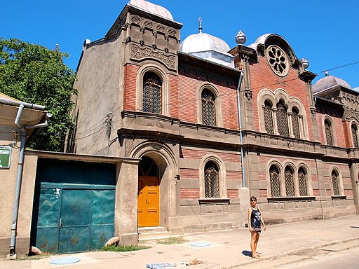
Synagogue
Sinagoga
Synagogue
Sinagoga

Harald Mandl, CC BY-SA 2.0, via Wikimedia Commons
Original function:
synagogue
Current function:
synagogue
Church:
Jewish
Settlement:
Address:
Strada Mihai Viteazu
Historical Hungarian county:
Krassó-Szörény
Country:
Romania
GPS coordinates:
45.2927452563, 21.8987617288
Google map:
Useful links
History
The Moorish-style synagogue was built in 1907 (other sources say 1914). The first record of the Jewish community (neolog) of Resica dates from 1870.
Check out other sights in Resicabánya as well!
Show on Google map
© OpenStreetMap contributors
{"item":"sight","set":{"sightId":1761,"townId":68,"active":1,"name_LO":"Sinagoga","address":"Strada Mihai Viteazu","mapdata":"1|922|242","gps_lat":"45.2927452563","gps_long":"21.8987617288","religion":6,"oldtype":"8","newtype":"8","homepage":"","openinghours":"","muemlekemlink":"","csemadoklink":"","picture":"\u003Ca title=\u0022Harald Mandl, CC BY-SA 2.0 <https:\/\/creativecommons.org\/licenses\/by-sa\/2.0>, via Wikimedia Commons\u0022 href=\u0022https:\/\/commons.wikimedia.org\/wiki\/File:Synagogue_resita.jpg\u0022\u003E\u003Cimg width=\u0022512\u0022 alt=\u0022Synagogue resita\u0022 src=\u0022https:\/\/upload.wikimedia.org\/wikipedia\/commons\/thumb\/a\/a2\/Synagogue_resita.jpg\/512px-Synagogue_resita.jpg\u0022\u003E\u003C\/a\u003E","picture_ref":"\u003Ca href=\u0022https:\/\/commons.wikimedia.org\/wiki\/File:Synagogue_resita.jpg\u0022\u003EHarald Mandl\u003C\/a\u003E, \u003Ca href=\u0022https:\/\/creativecommons.org\/licenses\/by-sa\/2.0\u0022\u003ECC BY-SA 2.0\u003C\/a\u003E, via Wikimedia Commons","name":"Synagogue","note":"","history":"The Moorish-style synagogue was built in 1907 (other sources say 1914). The first record of the Jewish community (neolog) of Resica dates from 1870.","town":{"townId":68,"name_HU":"Resicab\u00e1nya","name_LO":"Re\u0219i\u021ba","seolink":"resicabanya-resita","oldcounty":29,"country":4}},"language":"en","region":"romania","regionid":4,"offer":[],"gallery":false,"album":false}
