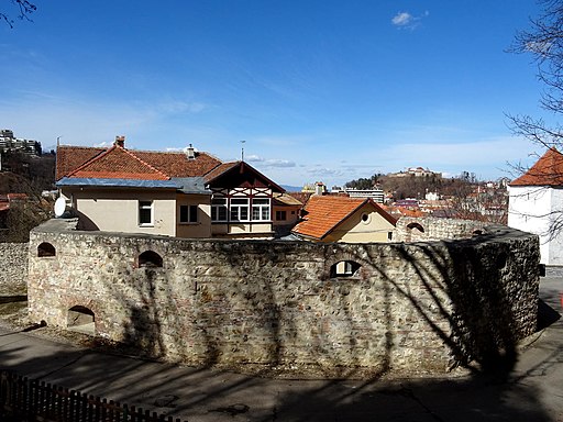
Ropemaker's Bastion, Seilerbastei
Bastionul Funarilor
Ropemaker's Bastion, Seilerbastei
Bastionul Funarilor
Original function:
town fortification
Current function:
town fortification
Address:
Aleea Tiberiu Brediceanu
Historical Hungarian county:
Brassó
GPS coordinates:
45.6395553075, 25.5926973846
History
According to some sources, it was mentioned as early as 1416. This is contradicted by the fact that the first documentary reference to a 'ropemakers' corner' (Saler Eck) dates back to 1562, and the first specific reference to a bastion (Söller Postay) dates back to 1613. It had to be rebuilt after fires in 1641 and 1689. It reinforced the southern defensive wall of the town. After its restoration, the bastion was used as a warehouse. In 1794, the ropemakers' guild built a guildhall inside the bastion. In 1894, it was sold to the manufacturer Karl Ganzert, who demolished the guildhall and built his high-rise apartment building, which still stands today. He dismantled most of the bastion, leaving only a low foundation which served as a fence, on which he opened a gate from the moat.
{"item":"sight","set":{"sightId":2020,"townId":77,"active":1,"name_LO":"Bastionul Funarilor","address":"Aleea Tiberiu Brediceanu","mapdata":"1|1532|2146","gps_lat":"45.6395553075","gps_long":"25.5926973846","religion":0,"oldtype":"24","newtype":"24","homepage":"","openinghours":"","muemlekemlink":"https:\/\/www.muemlekem.hu\/hatareset\/Varosi-eroditesrendszer-Brasso-1052","csemadoklink":"https:\/\/lexikon.adatbank.transindex.ro\/muemlek.php?id=272","picture":"\u003Ca title=\u0022Whitepixels, CC0, via Wikimedia Commons\u0022 href=\u0022https:\/\/commons.wikimedia.org\/wiki\/File:BVFunariBastion3.jpg\u0022\u003E\u003Cimg width=\u0022512\u0022 alt=\u0022BVFunariBastion3\u0022 src=\u0022https:\/\/upload.wikimedia.org\/wikipedia\/commons\/thumb\/6\/69\/BVFunariBastion3.jpg\/512px-BVFunariBastion3.jpg\u0022\u003E\u003C\/a\u003E","picture_ref":"\u003Ca href=\u0022https:\/\/commons.wikimedia.org\/wiki\/File:BVFunariBastion3.jpg\u0022\u003EWhitepixels\u003C\/a\u003E, CC0, via Wikimedia Commons","name":"Ropemaker's Bastion, Seilerbastei","note":"","history":"According to some sources, it was mentioned as early as 1416. This is contradicted by the fact that the first documentary reference to a 'ropemakers' corner' (Saler Eck) dates back to 1562, and the first specific reference to a bastion (S\u00f6ller Postay) dates back to 1613. It had to be rebuilt after fires in 1641 and 1689. It reinforced the southern defensive wall of the town. After its restoration, the bastion was used as a warehouse. In 1794, the ropemakers' guild built a guildhall inside the bastion. In 1894, it was sold to the manufacturer Karl Ganzert, who demolished the guildhall and built his high-rise apartment building, which still stands today. He dismantled most of the bastion, leaving only a low foundation which served as a fence, on which he opened a gate from the moat.\n&\nwikipedia: K\u00f6t\u00e9lver\u0151k b\u00e1sty\u00e1ja|https:\/\/hu.wikipedia.org\/wiki\/K%C3%B6t%C3%A9lver%C5%91k_b%C3%A1sty%C3%A1ja\nwelcometoromania.eu: Brass\u00f3, K\u00f6t\u00e9lver\u0151k b\u00e1sty\u00e1ja|https:\/\/www.welcometoromania.eu\/Brasov\/Brasov_Bastionul_funarilor_m.htm","town":{"townId":77,"name_HU":"Brass\u00f3","name_LO":"Bra\u0219ov","seolink":"brasso-brasov","oldcounty":40,"country":4}},"language":"en","region":"romania","regionid":4,"offer":[],"gallery":false,"album":false}

